Fort St. Philip
The barbed wire went up in 1964. Leander Perez, the segregationist political boss of Plaquemines Parish, needed somewhere to lock away civil rights demonstrators, and the abandoned fortification on the Mississippi's eastern bank suited his purposes perfectly. Fort St. Philip had been built to keep invaders out. Now it would keep Americans in. That grim irony is only one chapter in the fort's long, strange life -- a life that has seen Spanish colonial engineers, British naval bombardments, Union mortar boats, tanning vats, and a small spiritual community calling itself the Christos family, all passing through the same crumbling brick walls.
Spain's Sentinel on the River
The original fort on this site was Fort San Felipe, constructed during the 18th century when Spain controlled Louisiana. Positioned on the eastern bank of the Mississippi River, roughly sixty miles upriver from its mouth, the location was strategic genius: any ship bound for New Orleans had to pass within cannon range. The river here is narrow enough and bends just enough that a fort on this bank could rake approaching vessels with sustained fire. When the United States gained control of Louisiana, the strategic value of this bottleneck only grew. Fort St. Philip became the lower jaw of a defensive vice, with Fort Jackson directly across the river forming the upper. Together, the two forts guarded the only practical water route to the largest port on the Gulf Coast.
Ten Days of British Guns
During the War of 1812, while Andrew Jackson fought the famous land battle at New Orleans, Fort St. Philip faced its own test. On January 9, 1815, British naval forces opened a bombardment on the fort, attempting to force the river passage and approach New Orleans from downstream. The garrison held firm. For ten consecutive days, British shells rained down on the masonry walls, but the fort refused to break. The British finally withdrew, their fleet unable to pass. Jackson himself acknowledged the fort's contribution in a dispatch to the Secretary of War, writing that he was strengthened 'not only by the defeat of the British at New Orleans... but by the failure of his fleet to pass Fort St. Philip.' The bombardment demonstrated what the site's Spanish builders had understood decades earlier: whoever held this bend in the river controlled access to New Orleans.
Twelve Days That Fell a City
The current fort was constructed at the urging of Andrew Jackson, paired again with Fort Jackson across the river as twin guardians of the Mississippi. That defensive partnership faced its ultimate test in April 1862 during the Civil War. Union forces under Admiral David Farragut launched a sustained assault on both forts, bombarding Fort St. Philip for twelve grueling days. The engagement proved decisive -- not because the fort surrendered easily, but because Farragut eventually ran his fleet past the forts in the darkness, making the capture of New Orleans inevitable. The fall of New Orleans was a catastrophic blow to the Confederacy, sealing off the South's largest city and most vital port. Fort St. Philip, which had repelled the British half a century earlier, could not hold back the industrial might of the Union Navy.
A Fort's Unlikely Afterlives
After the Civil War, the fort was refortified during the Spanish-American War of 1898, adding new buildings including three two-story officers' quarters and an officers' club. But military relevance faded, and the fort cycled through increasingly unexpected incarnations. In the 1930s, it served as a tanning factory. During the civil rights era, Perez turned it into a threatened detention site for those who dared challenge segregation in his parish. Then, from 1978 through 1989, the old military compound became home to Vella-Ashby, an intentional, nonsectarian spiritual community. Up to 16 members of the Christos family lived in those repurposed officers' quarters, finding peaceful community in a place built for war. The fort was declared a National Historic Landmark in 1960, recognizing its layered significance to American history.
The River Takes It Back
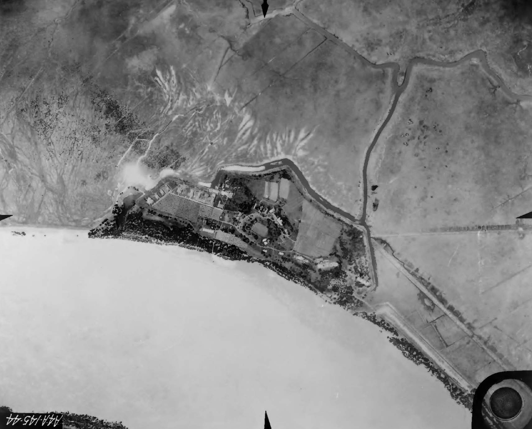
Today, Fort St. Philip is slowly surrendering to the Mississippi. Erosion of the small levee that once protected the site has left the ruins vulnerable to flooding during high water. The masonry walls that withstood British cannonballs and Union mortar shells are no match for the patient, relentless force of the river itself. From the air, the fort's star-shaped outline is still visible on the eastern bank, a geometric mark among the marshes and sediment of Plaquemines Parish. Fort Jackson, its partner across the water, is better preserved and open to visitors. Fort St. Philip, more remote and harder to reach, keeps its stories to itself -- a ruin that witnessed the defense of a nation, the oppression of its citizens, and the quiet hopes of a spiritual commune, all within the same eroding walls.
From the Air
Located at 29.364N, 89.464W on the eastern bank of the Mississippi River in Plaquemines Parish, Louisiana. Best viewed at 1,500-2,500 feet AGL. The star-shaped fort outline is visible among the marshland, directly across from Fort Jackson on the western bank. The two forts mark a distinctive narrowing of the river. Nearest airports: Belle Chasse Naval Air Station (KNBG) approximately 30nm upriver, South Lafourche Airport (KGAO) approximately 35nm west. The Mississippi River Delta stretches southeast from here toward the Gulf. Expect low-lying terrain with extensive wetlands; river fog common in morning hours.