Fort Stevens
Seventeen shells arced out of the darkness on the night of June 21, 1942. The Japanese submarine I-25 had surfaced off the Oregon coast and opened fire on Fort Stevens with its deck gun, making this the first attack on a mainland U.S. military installation during World War II. The commanding officer ordered his men not to return fire -- he did not want muzzle flashes revealing the battery positions. When dawn came and the damage was assessed, the tally was almost comically anticlimactic: one destroyed baseball backstop. The fort itself was untouched. But the story of Fort Stevens stretches far beyond that single bizarre night. For eighty-four years, from the Civil War through the atomic age, this earthwork-turned-fortress guarded one of the most strategically vital waterways on the Pacific coast.
The Fort at Point Adams
Fort Stevens began in 1863 as a crude earthwork battery on the south shore of the Columbia River's mouth, built during the Civil War to defend against a British attack that, in truth, seemed unlikely but not impossible. The Pig War of 1859 had brought Britain and the United States to the brink of conflict over the San Juan Islands, and tensions in the Pacific Northwest ran higher than most Americans today realize. Originally called the Fort at Point Adams, it was renamed in 1865 for Isaac I. Stevens, the former territorial governor of Washington who had been killed at the Battle of Chantilly in 1862. Fort Stevens anchored a three-fort harbor defense system at the Columbia's mouth, joined by Fort Canby and Fort Columbia on the Washington shore. Together they formed a triangle of firepower meant to ensure that no hostile fleet could push upriver.
Secrets on the Roof
Between the world wars, Fort Stevens took on a quieter but more sensitive mission. In 1932, the Navy co-located a secret radio intercept station at the fort, designated Station S, staffed by specially trained radiomen from the so-called On-the-Roof-Gang -- codebreakers who had learned their craft in a classroom atop the Navy Department building in Washington, D.C. Their job was to listen to Japanese naval coded messages, work that would prove prescient within a decade. By 1939, the Navy relocated Station S to Fort Ward on Bainbridge Island, where intercept conditions were better, but the fort's brief chapter in signals intelligence hints at a military landscape far more complex than its earthwork batteries suggest.
The Night the Submarine Came
The I-25's shelling on June 21-22, 1942, lasted only minutes. The submarine's 14-centimeter deck gun was a modest weapon, and the crew fired blindly toward shore in the dark. Seventeen rounds hit sand, brush, and the unfortunate baseball field. No one was injured. The decision not to return fire was tactical -- the fort's gun positions were camouflaged, and revealing them to protect a baseball diamond made no sense. But the psychological impact rippled far beyond Clatsop County. West Coast residents, already anxious after Pearl Harbor and the internment of Japanese Americans, now had proof that enemy vessels were operating just offshore. The I-25 would return to Oregon waters later that year, launching an incendiary bombing mission from its floatplane over the forests near Brookings -- the only aerial bombing of the contiguous United States during the war.
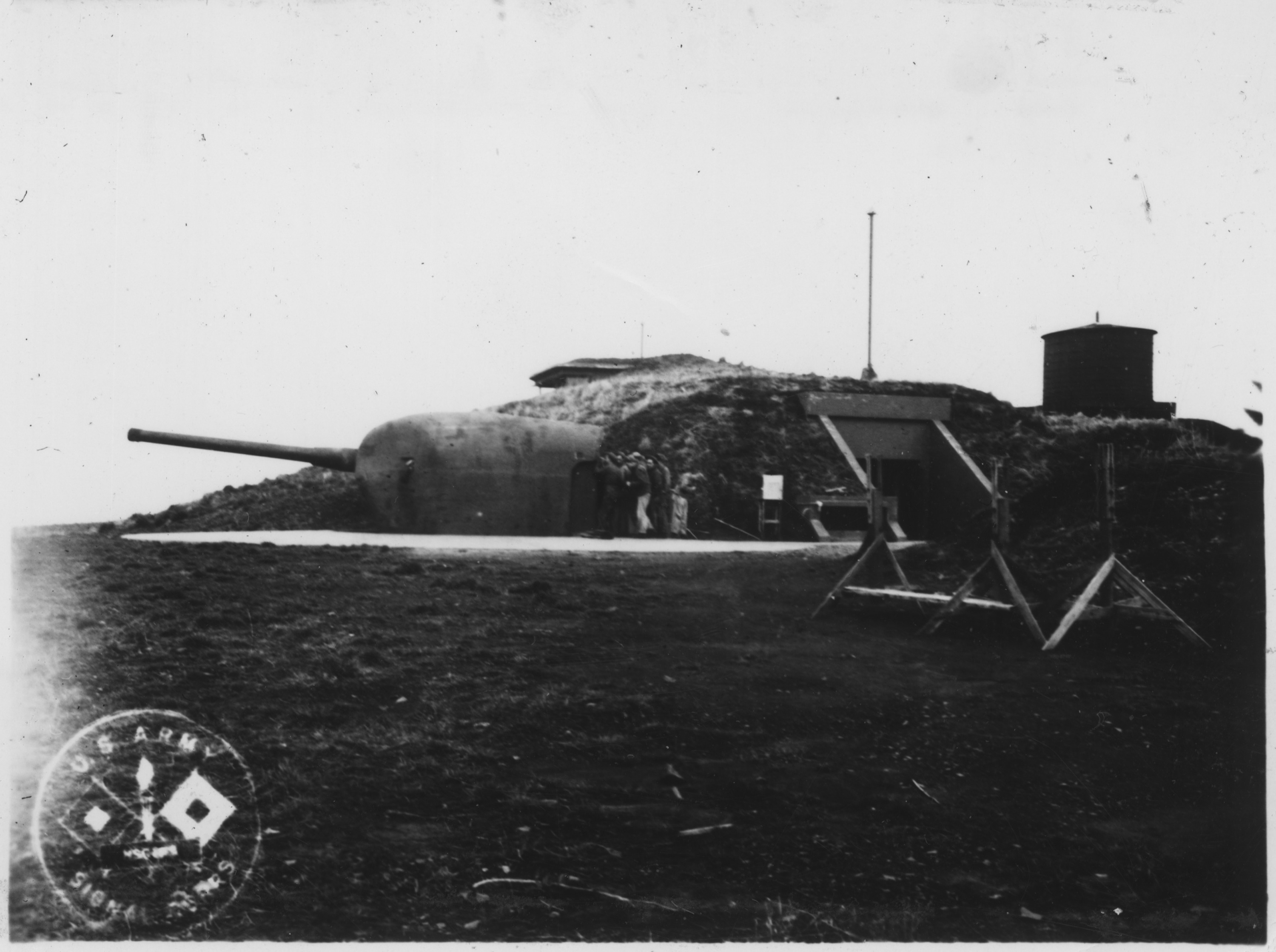
Bones of a Ship, Bones of a Fort
Fort Stevens was decommissioned in 1947. Its guns were removed, its buildings auctioned off, and its grounds transferred to the Army Corps of Engineers before finally reaching the Oregon Parks and Recreation Department in 1975. Today the 3,700-acre state park draws nearly 1.2 million visitors a year, making it one of the busiest parks in Oregon's system. Underground tours wind through the old military batteries, and Battery Russell still stands open to the wind, its concrete walls thick with moss. But the park's most photographed landmark predates even World War I. In 1906, the four-masted sailing ship Peter Iredale ran aground on Clatsop Spit, and her rusting iron skeleton remains embedded in the sand within the park's boundaries -- a monument to the Columbia River Bar's fearsome reputation as the Graveyard of the Pacific.
Where Wars Met the Water
From the air, the mouth of the Columbia is an enormous, shifting canvas of sandbars, breaking surf, and tidal current. Fort Stevens sits on the Oregon side of this chaos, a low headland that looks deceptively calm from altitude. The concrete outlines of old batteries are still visible through the tree canopy, and the Peter Iredale's ribs catch the light on the beach at low tide. It is a place where multiple centuries of American anxiety -- about the British, about the Japanese, about the sea itself -- left their marks in earthwork and concrete and rusting iron. The fort never fired a shot in anger. The one time an enemy attacked, the response was deliberate silence. That restraint may be the most memorable thing about it.
From the Air
Fort Stevens sits at 46.20°N, 123.96°W on the south shore of the Columbia River mouth, approximately 10 miles west of Astoria. Best viewed from 2,000-3,000 feet AGL, where the state park's 3,700 acres, beach access, and battery ruins are visible. The wreck of the Peter Iredale is often visible on the beach at low tide. Nearby airports: Astoria Regional Airport (KAST) is 8 miles east. The Columbia River Bar, Clatsop Spit, and the Pacific shoreline provide strong visual references. Expect coastal fog and low ceilings, especially in fall and winter.