Fort Ville-Marie
The name means 'City of Mary,' and the fifty or so French settlers who arrived at the Island of Montreal in May 1642 genuinely believed they were founding one. Recruited in France by Jerome Le Royer de la Dauversiere on behalf of the Societe de Notre-Dame de Montreal, they had crossed the Atlantic not to trade furs or claim territory but to convert Indigenous peoples and build a model Catholic community in the wilderness. Their leader, Paul de Chomedey de Maisonneuve, brought them to a spot on the St. Lawrence River where Samuel de Champlain had built a temporary fur-trading post three decades earlier. Here they raised Fort Ville-Marie - a modest wooden stockade that would become the nucleus of one of North America's great cities. Within a year, the Iroquois were raiding. Within a decade, the settlement nearly collapsed. But the 'City of Mary' held, and Montreal grew from its ashes.
Before the French
The Island of Montreal was not empty before European arrival. Archaeological work has revealed over 1,000 years of human habitation. When Jacques Cartier made his second expedition to North America in 1535, he encountered the village of Hochelaga near modern-day Montreal, home to the St. Lawrence Iroquoians, a group of sedentary farmers who had inhabited the valley between roughly 1200 and 1600 CE. But when Samuel de Champlain arrived in 1608, the Iroquoians had vanished. No trace remained of the settlements Cartier had described just 75 years earlier. Scholars have proposed devastating wars with the Iroquois to the south, epidemics of European diseases, or westward migration toward the Great Lakes. Historian Harold Innis theorized that northern hunting peoples around Tadoussac, armed with European weapons acquired through fur trade, pushed the farming peoples southward. By the time Champlain explored the area, the Algonquins and Mohawks used the St. Lawrence Valley only as hunting grounds and a corridor for war parties. No one lived there permanently upriver from Tadoussac.
Champlain's Footprint
Samuel de Champlain recognized the site's potential before anyone built a permanent settlement. In 1611, he constructed a temporary fort where present-day Pointe-a-Calliere stands, part of his vision for a French colonial empire. He cleared a site he named Place Royale, dug two gardens, and planted seeds that grew vigorously, confirming the soil's fertility. He returned in 1613 to inspect the site again. Champlain's Place Royale became the strategic point that later attracted the Ville-Marie settlers. The confluence of the St. Lawrence and Ottawa Rivers made it a natural crossroads for trade and travel into the continental interior. It was this geography - not religious ambition alone - that would ensure Montreal's survival and growth long after the original Catholic mission faded from the settlement's primary purpose.
The First Family Arrives
In 1641, roughly fifty settlers - men and women together - set sail for New France. After a long ocean crossing and several stops, the group arrived in Quebec under Maisonneuve's leadership, numbering about 40 men. Three brought their wives: Jean Gorry with Isabeau Panie, Antoine Damien with Marie Joly, and Nicolas Gode with Francoise Gadois and their four children - Francois, age 21; Francoise, 15; Nicolas, 13; and Mathurine, just 5 years old. The Godes are often called the 'First Family of Montreal.' An unmarried woman named Catherine Lezeau was also among them. They spent the winter near Sillery on land belonging to Pierre de Puiseaux. In May 1642, defying the governor of Montmagny who tried to redirect them to the safer Island of Orleans, the group sailed upriver to Montreal. They arrived on May 17. Among them was Jeanne Mance, who would soon establish the Hotel-Dieu de Montreal, the settlement's hospital, initially housed within the fort's walls.
A Fort Under Siege
Fort Ville-Marie was built on the very spot where Champlain had once camped, a wooden stockade sheltering as many as 50 colonists. The French and the Dutch - operating out of Fort Orange and New Amsterdam to the south - were both competing for the fur trade, and the Iroquois had allied with the Dutch, who supplied them with arms. War with the Iroquois began in 1641, even before Ville-Marie was established. By 1643, the fort was already absorbing raids. The situation grew dire enough that Maisonneuve sailed back to France in 1649 to seek reinforcements. He returned in 1653 with 100 settler-soldiers and 15 King's Daughters, young women placed under the care of Marguerite Bourgeoys. Between 1642 and 1676, the site also served as the annual meeting point for fur-trading fairs, where Amerindians brought pelts to exchange for French goods. The settlement's dual identity - religious mission and commercial outpost - would define Montreal's character for generations.
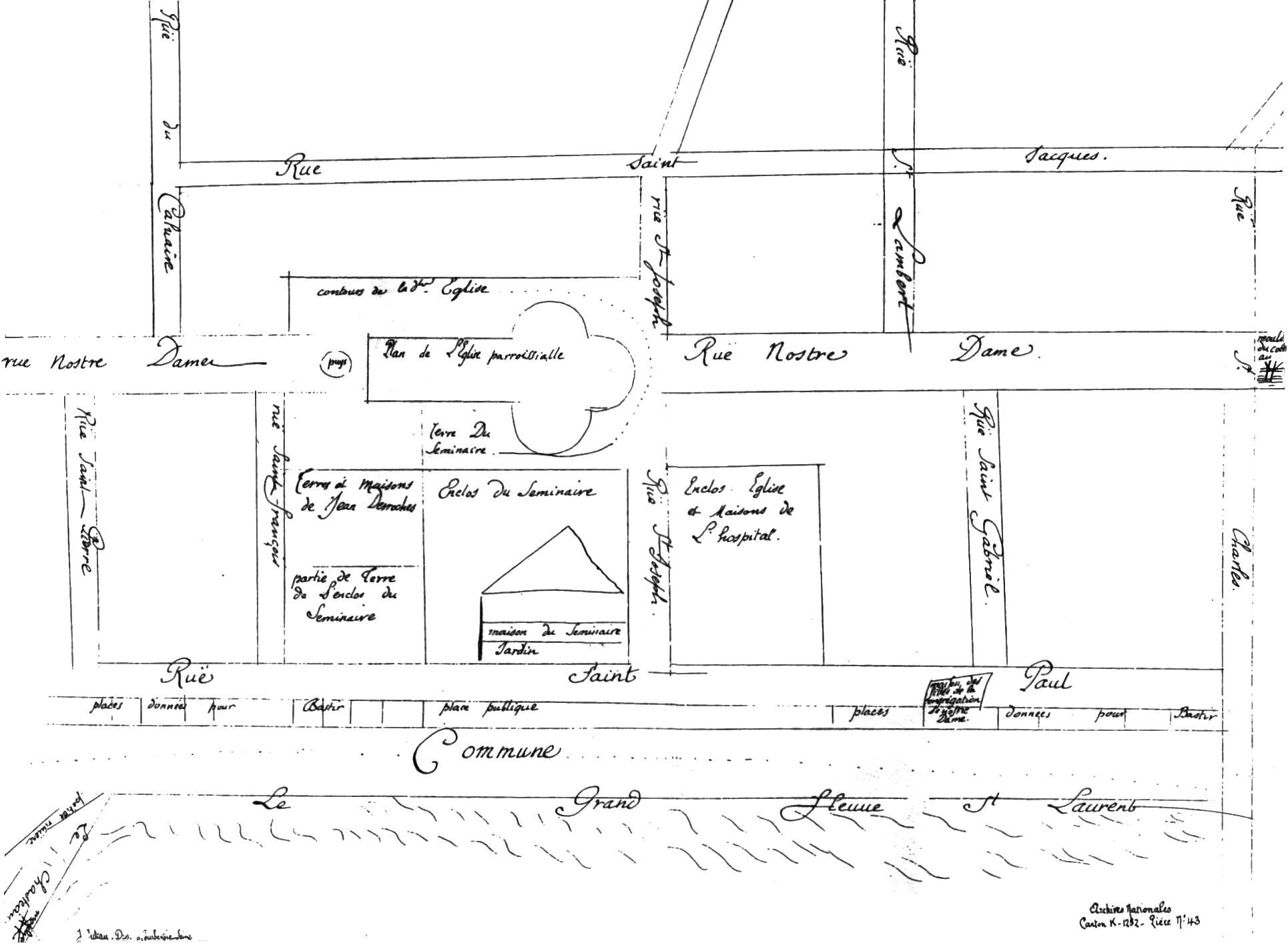
From Stockade to City
By 1685, Ville-Marie had grown to some 600 colonists living in modest wooden houses. The Sulpician fathers, who had become seigneurs of the Island, dominated the skyline with their parish church and seminary. Business centered on the marketplace near the mouth of a small river, where Montrealers and Amerindians met to trade. The original religious mission had not been abandoned, but the fur trade was now the settlement's economic engine. Fort Ville-Marie served as the hub for French expansion deep into North America until the Treaty of Paris in 1763 ended the French and Indian War and ceded New France to Britain. The fort itself was designated a National Historic Site of Canada in 1924. For centuries, its exact location was uncertain. Then in 2015, archaeologists uncovered one of the fort's corner posts - a physical remnant of the structure from which an entire metropolis grew. Today, the Pointe-a-Calliere Museum stands near the site, and visitors can walk the archaeological layers of Montreal's origins, descending through centuries of history to the very ground where fifty dreamers raised a wooden wall against the wilderness and called it a city.
From the Air
Located at 45.50°N, 73.55°W in Old Montreal, at the site of present-day Pointe-a-Calliere Museum near the Old Port. From altitude, look for the distinctive cobblestone streets of Old Montreal along the waterfront, with the Pointe-a-Calliere museum complex at the western end of the historic district where the small St. Pierre River once met the St. Lawrence. Notre-Dame Basilica and Place d'Armes are visible nearby. The Old Port's distinctive Bonsecours Market building and Clock Tower are landmarks along the waterfront. Nearest airport is Montreal-Pierre Elliott Trudeau International (CYUL), approximately 17 km west. Montreal/Saint-Hubert (CYHU) lies 13 km southeast. Best viewed at 2,000-4,000 ft AGL to appreciate Old Montreal's street grid and waterfront position at the confluence of the St. Lawrence and Ottawa Rivers.