Fortifications of Bangkok
Of the sixty-three gates that once ringed Bangkok's inner city, all bore enchantments against evil spirits -- except one. Pratu Phi, the Ghost Gate, carried no protective magic because its sole purpose was the transport of corpses out of the city. The dead, apparently, needed no warding. That detail captures something essential about Bangkok's vanished fortifications: they were shaped as much by spiritual logic as by military engineering, built to defend against threats both physical and supernatural across four centuries of war, revolution, and relentless urban expansion.
River Outpost, French Siege
Bangkok began as a military problem. Situated where the Chao Phraya River meets its old and new channels, the settlement guarded the water approach to the Ayutthaya kingdom's capital upstream. By the 15th century, city walls enclosed the west bank in a rectangular shape, with forts straddling the river channels. When the French-oriented King Narai commissioned Western-style bastion forts around 1685, he hired the French engineer de la Mare to oversee construction. Only the eastern fort was completed before the relationship between Siam and France collapsed spectacularly in the revolution of 1688. French troops garrisoned in the new fort found themselves besieged by Siamese forces for four months before being permitted to withdraw. The victorious Siamese then demolished the fort entirely -- European military architecture judged too dangerous to leave standing, even empty.
Fourteen Forts for a New Capital
When Rama I established Rattanakosin as his capital in 1782, he needed fortifications fast. He had new outer moats dug, creating the island that still bears the name Rattanakosin, and built fourteen forts in a clockwise ring around the perimeter. The construction materials came from everywhere: Taksin's dismantled city walls from Thonburi, the ruins of King Narai's French-designed fort, and salvaged stone from the destroyed Ayutthaya. Each fort received a name -- Phra Sumen at the north, Mahakan to the east, Chak Phet guarding the canal mouth to the south. The octagonal Phra Sumen Fort, 45 meters in diameter and 10.5 meters high with sema-shaped battlements, anchored the northern defenses where the moat met the river. Its roofed heptagonal tower collapsed sometime between the reigns of Rama V and Rama VII and was rebuilt in 1981 for the city's bicentennial.
Built for War, Spared by History
Rama I's ring of forts addressed a specific fear: Burmese invasion. The threat was real -- Burma and Siam had fought devastating wars for centuries, and Ayutthaya had fallen just fifteen years earlier. But the anticipated assault never materialized. The Anglo-Burmese Wars drew Britain into Burma's territory, and British colonization removed the Burmese military threat permanently. Bangkok's fortifications, built at enormous expense from the rubble of a destroyed civilization, never fired a shot in anger. Instead, progress did what the Burmese could not. In the second half of the 19th century, as Bangkok expanded beyond its moats and canals, the walls and forts were systematically dismantled to make room for roads, bridges, and a growing city that had outgrown its military skin.
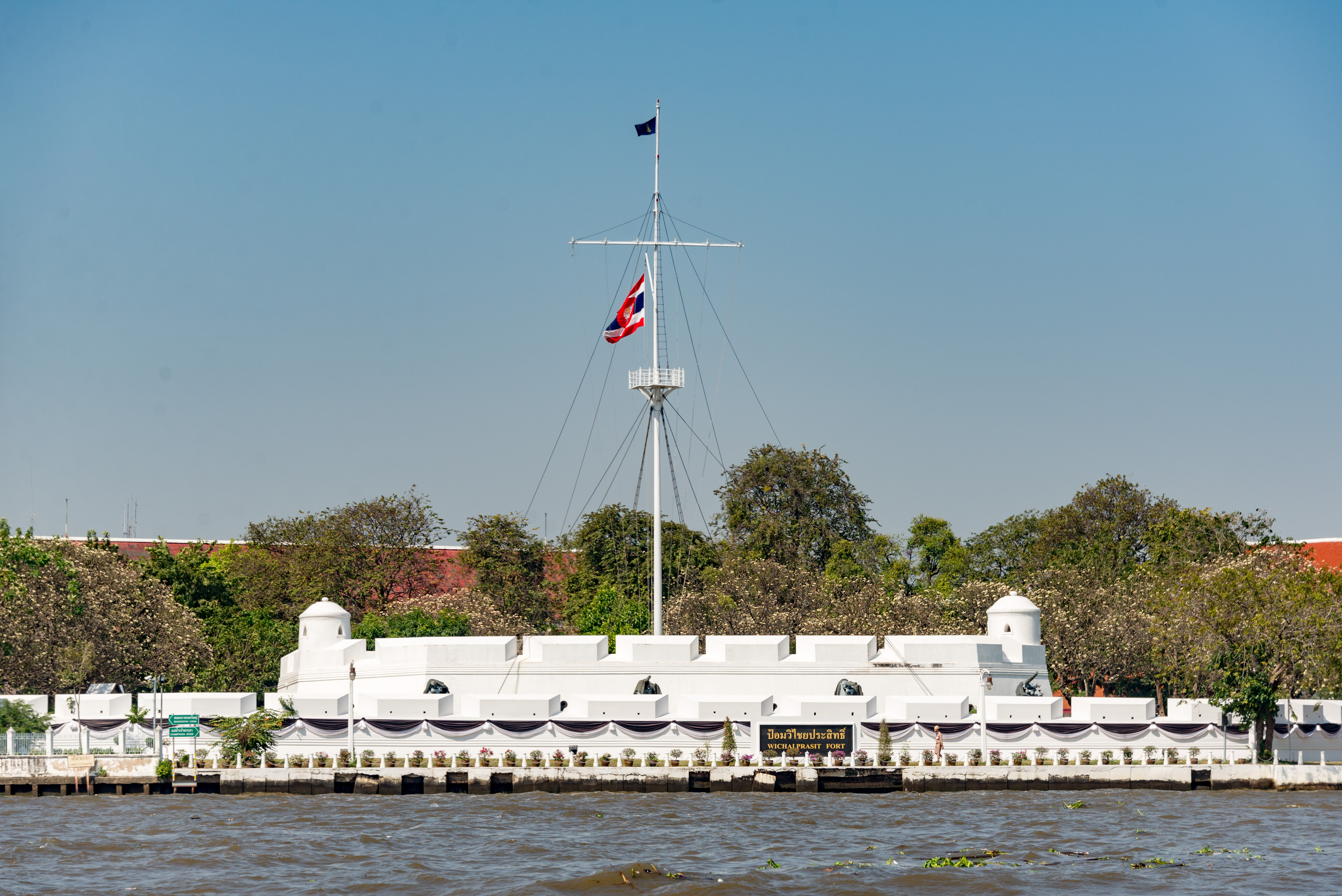
What the City Kept
Today, four forts survive. Wichaiprasit Fort, the oldest, remains in military hands under the Royal Thai Navy. Phra Sumen Fort stands in Santichaiprakan Park, opened in 2000, where joggers circle the battlements at dawn. Mahakan Fort, 38 meters in diameter and 19 meters tall, still connects to a 180-meter section of the original city wall near Phan Fa Lilat Bridge. The community of wooden houses that once clustered between the fort and the canal -- a living museum of vernacular architecture -- was evicted by the Bangkok Metropolitan Administration in 2018, the area converted to a public park. A 40-meter section of wall also survives in front of Wat Bowonniwet, complete with a tower gate whose collapsed 12-meter pointed roof was reconstructed in 1981 using photographs from King Rama V's era. These fragments, along with the canals that formed the original moats, are registered ancient monuments -- the last physical evidence of a city that once expected war at its gates.
From the Air
Located at 13.742N, 100.491E on Rattanakosin Island in central Bangkok. The remaining forts are small structures best identified at low altitude (1,500-2,500 feet). Phra Sumen Fort is visible at the northern tip of the island where the moat canal meets the Chao Phraya River, adjacent to the green space of Santichaiprakan Park. Mahakan Fort sits near Phan Fa Lilat Bridge on the eastern edge. The moat canals (Khlong Rop Krung) tracing the old fortification line remain visible as waterways through the urban fabric. Nearest airports: Don Mueang (VTBD) approximately 15 nm north; Suvarnabhumi (VTBS) approximately 18 nm east-southeast.