Fortifications of Kotor
The walls begin at the waterfront and simply refuse to stop climbing. From the Sea Gate, built in 1555 where the Adriatic laps against Kotor's medieval quarter, ramparts scale the flank of St. John Mountain in a series of improbable zigzags until they reach the castle of San Giovanni, 280 meters above the bay. The fortifications of Kotor run 4.5 kilometers in circumference, range from 2 to 16 meters thick, and rise up to 20 meters high. They incorporate the military engineering of every power that held this corner of the Adriatic -- Illyrians, Byzantines, Venetians, Austrians, and briefly the French and British -- layered so densely that separating one era's stonework from another requires an archaeologist's eye. In 1979, UNESCO inscribed the walls and the old town they protect as the Natural and Culturo-Historical Region of Kotor, Montenegro's sole cultural World Heritage Site.
Empires Written in Stone
The hilltop above Kotor was fortified in Illyrian times, before written records reached this part of the Adriatic. In the 6th century, the Byzantine emperor Justinian I rebuilt the fortress, establishing the defensive logic that every subsequent ruler would follow: control the mountain, control the bay. When Venice took possession in 1420, absorbing the independent Republic of Cattaro into its Albanian provinces, the fortifications received the structure that survives today -- massive bastions, gated entries, and the climbing ramparts that make Kotor's walls unlike any other medieval fortification in Europe. Two Ottoman sieges tested those walls, from 1538 to 1571 and again from 1657 to 1699, but both failed. The Venetians held.
Cannons Hauled Uphill
The fortifications changed hands with the treaties of European power politics. The Habsburgs took over in 1797 via the Treaty of Campo Formio. Napoleon's Kingdom of Italy claimed them in 1805 through the Treaty of Pressburg, though Russian troops under Admiral Dmitry Senyavin occupied the fortress until the Treaty of Tilsit removed them in 1807. By 1810, Kotor had been absorbed into the French Empire's Illyrian Provinces. It was during this period that British naval captain William Hoste, commanding HMS Bacchante with its 38 guns, devised what even contemporaries called an unmilitary approach: he hauled his ship's cannons to positions above the fort using block and tackle, then shelled the fortifications from the heights that were supposed to protect them. After the Congress of Vienna, Austria reclaimed the fortress and held it until the end of World War I, when the garrison departed for good.
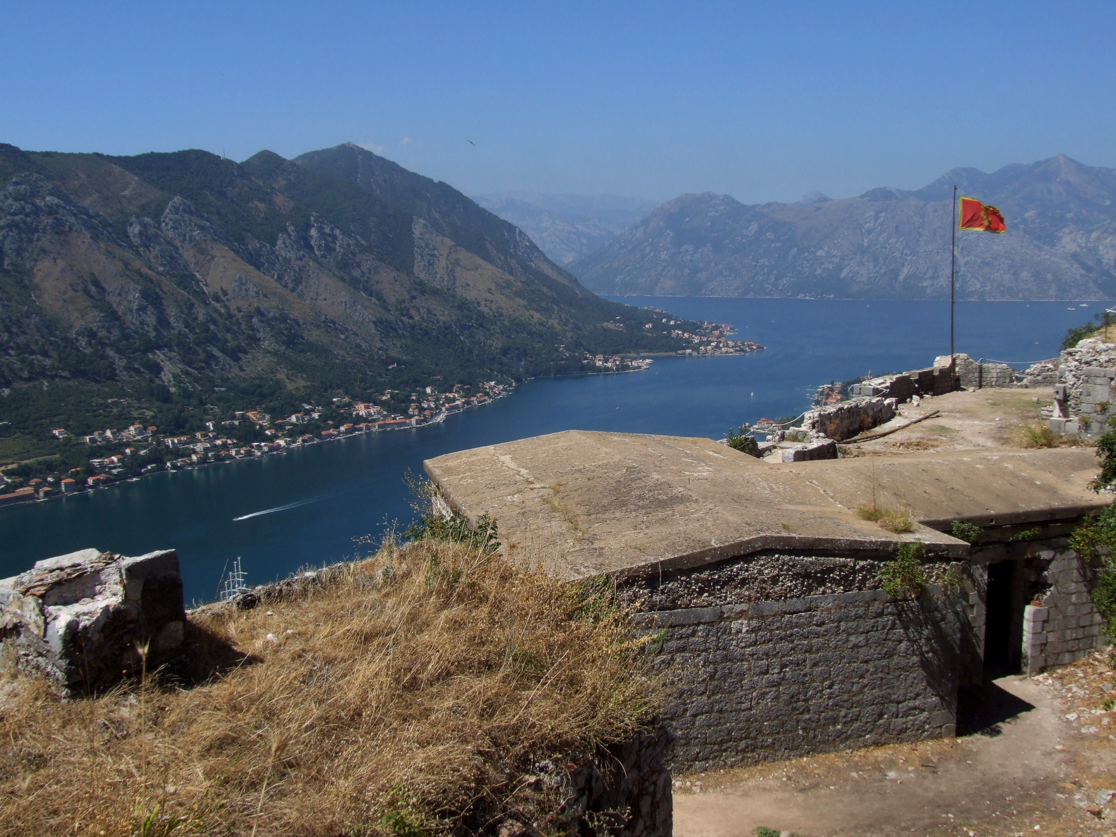
Three Gates, One Triangle
Kotor's medieval quarter occupies a triangular piece of land pinched between the bay to the southwest, the river Skurda to the north, and St. John Mountain to the east. Three gates pierce the walls: the Sea Gate on the waterfront, the River Gate to the north near the Bembo Bastion -- both dating from the 1540s and 1550s -- and the much-modified Gurdic Gate to the south, fortified by its own bastion since 1470. The Kampana tower and citadel, dating from the 13th and 14th centuries, guard the point where the river meets the bay. Between the bastions and the summit castle, a network of footpaths, stairs, and communication trenches threads through the ramparts, passing the Church of Our Lady of Remedy, built in 1518 on a terrace partway up the mountain. Today the Bembo Bastion has been repurposed as an open-air theater, hosting performances under walls that once deflected cannonballs.
Earthquake, Neglect, and Slow Revival
On April 15, 1979, a severe earthquake struck the Montenegrin coast, damaging much of Kotor's old town and its fortifications -- the third major quake after those of 1563 and 1667. UNESCO placed the site on both the World Heritage List and the List of World Heritage in Danger that same year. Rehabilitation efforts focused primarily on the old town, and the site was removed from the danger list in 2003. But the fortifications themselves -- abandoned since the Austrian departure in 1918, eroded by weather, cracked by seismic activity, and slowly consumed by vegetation -- remained in poor condition. The European Commission assessed the walls and proposed a comprehensive restoration of the hillside ramparts, towers, footpaths, and accessory buildings, recognizing the fortifications as both a cultural treasure and an economic resource for a town increasingly dependent on tourism. The work continues, stone by stone, on walls that have been someone's responsibility for two thousand years.
From the Air
Located at 42.4249N, 18.7710E at the innermost point of the Bay of Kotor, Montenegro. The fortifications are dramatically visible from the air -- a white-gray line of walls zigzagging up the dark green mountainside from the compact orange-roofed old town to the San Giovanni castle at 280 meters elevation. The bay narrows to its tightest point here, with Mount Lovcen (1,749 m) rising steeply behind. Tivat Airport (LYTV) is approximately 12 km to the west across the bay. Recommended viewing altitude 2,000-4,000 feet AGL to see the full climb of the ramparts. Cruise ships regularly anchor in the bay directly below the fortifications during summer.