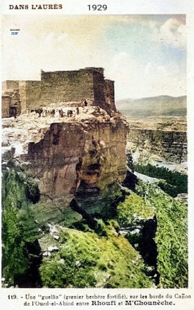
Fortified Granaries of Aures
Eight stories of dry stone rise from a rocky hilltop in the Aures Mountains, accessible only by a single narrow path. This is not a castle. It is a granary -- a taq'liath in the Shawiya language -- and the clan that built it, the Ait Daoud, still climb to its upper chambers each May to sacrifice animals and share a communion meal in honor of their ancestral saints. The fortified granaries of the Aures have served as grain stores, defensive strongholds, and spiritual centers for communities that predate the Romans, outlasted the Byzantines, and resisted both Arab and French conquest. They are among the most remarkable and least known structures in North Africa.
Eagle Nests
In 1878, French anthropologist Emile Masqueray traveled into the Aures and encountered structures he described as "eagle nests" -- multi-storied stone buildings perched on high ground, often with a single gateway and walls thick enough to withstand siege. These were not new discoveries. The 11th-century Andalusian historian Al-Bakri had noted that the Aures contained "a large number of fortresses surrounded by water streams," home to the Miknasa and Houara Berber tribes. Before Al-Bakri, the Roman historian Sallust described Jugurtha's treasure houses in language that could serve as a blueprint for the granaries: strongholds on rocky hills, narrow approaches, single points of entry. Historians have identified specific granaries -- at Ath Mansur and Jellal -- with these ancient Numidian fortifications, suggesting a building tradition that stretches back more than two millennia.
Architecture of Survival
The granaries are predominantly stone-built, their roofs reinforced by palm tree trunks, their shapes usually square. Some include small openings for ventilation and light, adorned with symbolic decorations reflecting the community's connection to agriculture and nature. But the real engineering genius lies in the water systems. High-elevation springs fed reservoirs that filled at night, with water channeled through networks of miniature canals to irrigate terraced gardens below. The agricultural cycle was vertically organized: crops grew on terraces carved into the hillside, while the harvest was stored above in chambers that could be sealed and defended. The development from simple cave dwellings to these multi-storied structures represents a continuum of architectural evolution driven by one unchanging reality -- open fields were vulnerable to raids by camel-mounted marauders from the plains.
Water as Weapon
The granaries were not merely places to store grain. They were fortresses, and their defenders understood hydraulic warfare. The Byzantine historian Procopius recorded how Iaudas, ruler of the Aures kingdom, used the region's water canals to divert streams and repel Roman invaders. Centuries later, in the 17th century, the same tactics appeared again in the same mountains: Auresian defenders flooded the fields surrounding their granaries to trap and destroy invading Arab Bedouins. The tactic worked because it exploited geography that outsiders never fully understood -- the intricate relationship between mountain springs, canal networks, and the terrain that channeled water downhill toward any force foolish enough to camp in the lowlands.
Berber Republics in Stone
Historian Jean Despois argued that the granaries embodied the Auresian political order: power held by family heads within clans, decisions made by elected representatives, no central authority. These "Berber republics" resisted both Arabization and colonial control, and the granaries symbolized their autonomy. Each community's granary was communal property -- a shared resource that bound families together through mutual obligation. The Auresians attributed their terracing techniques to the Romans, but the influence likely extended to earlier Numidian civilizations that refined existing North African agricultural methods. While French colonial rule diminished the use of granaries as dwellings, their cultural significance endures. In 2023, advocacy from local activists drew the attention of an Italian mission from the University of Padua, which toured the region to assess the structures -- a first step toward the international recognition that these extraordinary buildings deserve.
From the Air
Located at 35.09N, 6.03E in the Aures Mountains of northeastern Algeria. The granaries are scattered across hilltops in rugged mountain terrain. Nearest airport: DAUB (Mohamed Khider Airport, Biskra), approximately 50 km south. The Aures range is clearly visible from altitude, with the granaries' hilltop positions potentially identifiable at lower altitudes in clear conditions.