Fortress of Humaita
They called it the Gibraltar of South America, and for a landlocked country with no navy to speak of, that was the whole point. The Fortress of Humaita sat on a sharp horseshoe bend in the Paraguay River, a chokepoint so tight that any vessel wishing to enter the republic had to pass within 200 yards of its guns. For fourteen years, from its hasty construction in 1854 to its fall in 1868, Humaita was the lock on Paraguay's front door -- and for the three nations that tried to break it open, the key to the deadliest war in South American history.
A Fortress Built in Fifteen Days
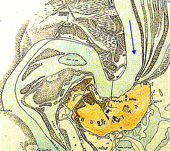
Paraguay's president Carlos Antonio Lopez started fortifying Humaita in a panic. In 1854, a Brazilian flotilla was steaming upriver to press territorial claims, and Lopez had nothing between those warships and his capital at Asuncion. He transferred 6,000 troops to the site and set them working day and night. In fifteen days they had batteries in place, including furnaces for heating cannonballs to red-hot temperatures -- projectiles that could set wooden warships ablaze. The Brazilians, seeing the fortifications, turned back. Over the following years, British engineers under contract to the Paraguayan government expanded the works. By 1859, the installation bristled with batteries: the Itapiru, the Pesada, the Coimbra, the Tacuari, the massive casemated Bateria Londres with walls 27 feet thick and 16 eight-inch guns, and finally the Bateria Cadenas, which guarded the chain boom stretched across the river to trap enemy ships under the guns.
The Bend That Swallowed Navies
Geography made Humaita formidable. The Vuelta de Humaita was a 1,500-meter horseshoe curve where the navigable channel narrowed to just 200 meters. The current ran at nearly three knots, strong enough to fight a steamship's rudder. Treacherous backwaters confused navigation in direct proportion to a vessel's length. Eight fixed batteries could concentrate converging fire on any ship rounding the bend. And beneath the brown surface drifted something worse than cannonballs: torpedoes. These improvised floating mines, packed with gunpowder and triggered by glass capsules of sulfuric acid, were released into the current almost every night. Most failed to detonate. But one sank the 1,000-ton Brazilian ironclad Rio de Janeiro, killing 155 men. After that, the Brazilian navy had patrol boats rowing in three shifts through the darkness, dragging grappling hooks through the water to snag the mines before they could reach the fleet.
The Quadrilateral
Humaita was not just a river battery. On the landward side, where the swamps did not provide natural protection, the Paraguayans constructed an elaborate system of earthworks stretching eight miles, known as the Quadrilateral. Lieutenant Colonel George Thompson, the British-born chief engineer of the Paraguayan army, personally surveyed every yard of it. The trenches were garrisoned by 18,000 men and mounted 120 cannon. Flood defenses at Paso Gomez could be opened by sluice gate to send a wall of water crashing into any attacking force. Telegraph lines connected every section of the Quadrilateral to Lopez's headquarters at Paso Pucu, where Guarani telegraphists -- who proved remarkably adept at Morse code -- relayed messages all day long. The allies, fighting in terrain they had never mapped, did not even realize the Quadrilateral existed until deep into the siege.
The Bluff Behind the Guns
For all its fearsome reputation, Humaita had weaknesses that its aura of invincibility concealed. Many of its guns were defective or obsolete. The en barbette emplacements left artillerymen dangerously exposed to enemy fire. When the British explorer Sir Richard Burton inspected the captured fortress in 1868, he thought its potency had been greatly exaggerated -- that it had been, in part, a magnificent bluff. The chain boom across the river, supposedly impassable, could not be drawn tight without floating supports; once Brazilian ironclads spent three months sinking those pontoons and canoes, the chains sank to the riverbed and offered no obstacle at all. Most critically, Humaita had been designed against wooden paddle-steamers. The ironclad revolution, demonstrated so dramatically at Hampton Roads in 1862, rendered the fortress obsolescent almost as soon as it was complete.
Pride Outlasting Stone
The Treaty of the Triple Alliance explicitly demanded the demolition of Humaita, and the victors razed it. But what they could not demolish was what it meant. The fortress had delayed armies vastly larger than Paraguay's own for more than two years. Its garrison endured starvation, cholera, and relentless bombardment rather than surrender. When it finally fell in July 1868, the defenders did not capitulate -- they escaped through the Chaco on a road they had hacked through 54 miles of wilderness. For Paraguayans today, Humaita remains a symbol of national resilience: a country that knew it was outmatched, that built its defenses anyway, and that held on far longer than anyone thought possible.
From the Air
Located at 27.07S, 57.75W on a pronounced horseshoe bend of the Paraguay River in Neembucu Department, southwestern Paraguay. The bend itself is clearly visible from altitude -- look for the tight U-shaped curve in the river. The terrain surrounding the fortress site is flat, marshy lowland typical of the Lower Paraguay floodplain. Nearest airport: Pilar Airport (SGPI) approximately 30 km southwest. The river channel is about 600 meters wide; the old fortress position is on the elevated left (east) bank, roughly 10 meters above the waterline. Best viewed at 3,000-6,000 ft AGL to appreciate the strategic geography of the bend.