Fossli Provincial Park
The name means "waterfall in the valley," and it was chosen by a Norwegian immigrant who saw something familiar in this corner of Vancouver Island. He had come from Eidfjord, a municipality in western Norway carved by glaciers and defined by cascading water, and when he settled on the shores of Sproat Lake near Port Alberni, he named his homestead after the place he had left behind. Fossli Provincial Park preserves that homestead's land, its waterfall, and a temperate rainforest that would not look out of place in a fjord country thousands of kilometres away.
A Gift of Land
Helen and Armour Ford donated the 52 hectares that became Fossli Provincial Park to the Province of British Columbia in 1974. The land sits on Stirling Arm of Sproat Lake, west of Port Alberni, accessible only by water or a private logging road -- a remoteness that has kept the park wild and lightly visited. A 30-minute hiking trail leads to the old homestead site, where the foundations and clearings hint at the life the Fords built beside the lake. The donation ensured that the forest, the waterfall, and the creek would remain undeveloped, a patch of old growth in a region where logging has reshaped vast stretches of the landscape.
A Rainforest in Miniature
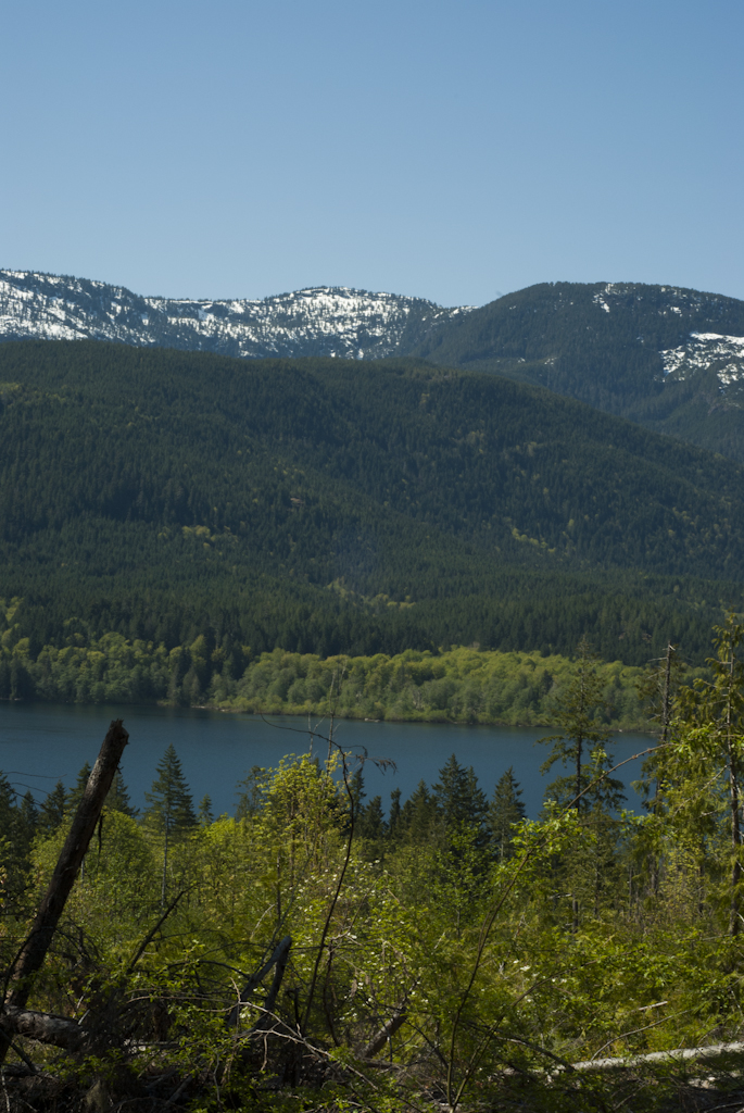
Fossli Provincial Park is small, but it contains a concentrated sample of Vancouver Island's coastal temperate rainforest. Giant bigleaf maples wear thick coats of moss, their branches drooping under the weight. Red alders rise from a floor of sword ferns, their pale bark wrapped in green. Salal bushes crowd the trailhead, their waxy leaves dripping in the frequent rain. Banana slugs -- the bright yellow, slow-moving icons of the Pacific Northwest forest floor -- are common along the trail, especially on wet days. The park has few services and draws few visitors, which is precisely its appeal: it offers an intimate encounter with old-growth forest without the crowds that gather at larger parks on the island.
Where the Salmon Return
Saint Andrew's Creek runs through the park and serves as a fall spawning ground for coho salmon. Every autumn, the fish fight their way upstream from Sproat Lake, navigating the shallow gravel beds where they were born to lay and fertilize their eggs before dying. The creek is small -- nothing like the major salmon rivers of the British Columbia coast -- but it is part of the vast network of tributaries and spawning channels that sustain the Pacific salmon runs. The presence of spawning coho in a park this small is a reminder of how thoroughly salmon penetrate the landscape of Vancouver Island, reaching into every creek, every side arm, every pocket of undisturbed habitat they can find.
Norway on the Pacific
The Norwegian immigrant who named this place recognized something specific: the combination of steep terrain, heavy rainfall, dense forest, and cascading water that defines both the fjords of western Norway and the inlets of Vancouver Island's west coast. Eidfjord, the municipality he left, sits at the inner end of Hardangerfjorden, one of Norway's longest and deepest fjords. Sproat Lake occupies a similar geography -- a long, narrow body of water carved by glacial action, flanked by mountains, fed by rain and snowmelt. The name Fossli was an act of memory, connecting two landscapes separated by an ocean but shaped by the same geological forces. The park preserves both the waterfall that inspired the name and the cultural connection that a single immigrant carried across the world.
From the Air
Fossli Provincial Park is located at approximately 49.250N, 124.950W on Stirling Arm of Sproat Lake, west of Port Alberni on Vancouver Island. The park is small (52 hectares) and heavily forested, making it difficult to identify from altitude. Use Sproat Lake as the primary landmark -- a long, narrow lake running east-west -- and look for Stirling Arm branching to the south. Port Alberni Airport (CBS8) is approximately 8 nm to the east. Best viewed at 1,500-2,000 feet AGL. The broader Alberni Valley and the chain of lakes (Sproat Lake, Great Central Lake) are prominent visual features for orientation.