The Frank Slide
At 4:10 AM on April 29, 1903, Turtle Mountain fell on the town of Frank, Alberta. In approximately 100 seconds, 110 million tonnes of limestone crashed 900 meters down the mountainside and swept across the valley, burying the eastern edge of town, the coal mine entrance, and part of the Canadian Pacific Railway under 30 meters of rock. At least 70 people died - the exact number is unknown because some miners and transients were never accounted for. The Frank Slide remains Canada's deadliest rockslide. Today, the debris field stretches across 3 square kilometers, the grey limestone rubble looking fresh despite over a century of weathering. The mountain still looms above, its scar visible for miles.
The Mountain
Turtle Mountain was unstable from the beginning. The limestone peak sits on softer shale, creating a geological imbalance. The mountain's east face was already fractured and leaning. The Canadian-American Coal and Coke Company began mining coal from the mountain's base in 1901, removing material that had been supporting the unstable mass. Indigenous peoples had long called the mountain 'the mountain that moves' and avoided camping near it. Engineers and geologists would later identify the conditions that made the slide inevitable: steep slopes, fractured rock, weak foundation, and mining undercutting the base. On the night of April 28, 1903, all these factors combined.
The Slide
The collapse lasted approximately 100 seconds. A massive wedge of limestone, roughly 2,100 feet high, 3,000 feet wide, and 500 feet thick, broke from Turtle Mountain and fell 900 meters into the valley. The rock mass reached speeds estimated at 112 km/h, generating air blasts that destroyed structures outside the debris field. The slide buried the eastern portion of Frank, including homes, the mine entrance, and 7,000 feet of railway. It crossed the valley and climbed 400 feet up the opposite slope. The noise was heard 200 kilometers away. In the town, survivors woke to find their neighbors gone, buried under rock that would prove impossible to excavate.
The Survivors
Amid the catastrophe, remarkable survival stories emerged. Seventeen miners were working underground when the slide buried the mine entrance. They dug through 10 meters of coal and rock over 13 hours to escape through a coal seam. An infant named Gladys Ennis was reportedly thrown from the debris still in her cradle, surviving uninjured - though historians debate this story. The Bansemer family was sleeping in a house at the edge of the slide; the baby was found unhurt amid the rubble. But most in the slide's path had no chance. Bodies were never recovered from the deep debris; the town eventually stopped trying.
The Aftermath
The town of Frank survived, relocating away from the mountain's base. The coal mine reopened briefly but closed within a decade. The Canadian government commissioned studies that identified the slide's causes and predicted the mountain remained unstable - it still is. Modern monitoring equipment tracks Turtle Mountain's movements, and evacuation plans exist for nearby communities. The debris field was never cleared; the rocks remain where they fell. The Frank Slide Interpretive Centre opened in 1985, telling the story of that 100-second catastrophe. The debris field itself is the primary exhibit - square kilometers of jumbled grey rock marking where a mountain fell and a town died.
Visiting the Frank Slide
The Frank Slide Interpretive Centre is located on Highway 3 in the Crowsnest Pass, Alberta, 2 kilometers east of the site of old Frank. The centre offers exhibits, films, and guided walks through the debris field. Admission is charged. The debris field is visible from Highway 3 and from the interpretive centre's viewpoint. Walking trails cross portions of the rubble. The scar on Turtle Mountain is still visible. Nearby Bellevue has a mine tour. The Crowsnest Pass has basic services; Lethbridge is 100 kilometers east. Calgary International Airport is 250 kilometers northeast. The debris field is impressive in winter snow but most accessible May through October. The mountain still moves - monitoring continues.
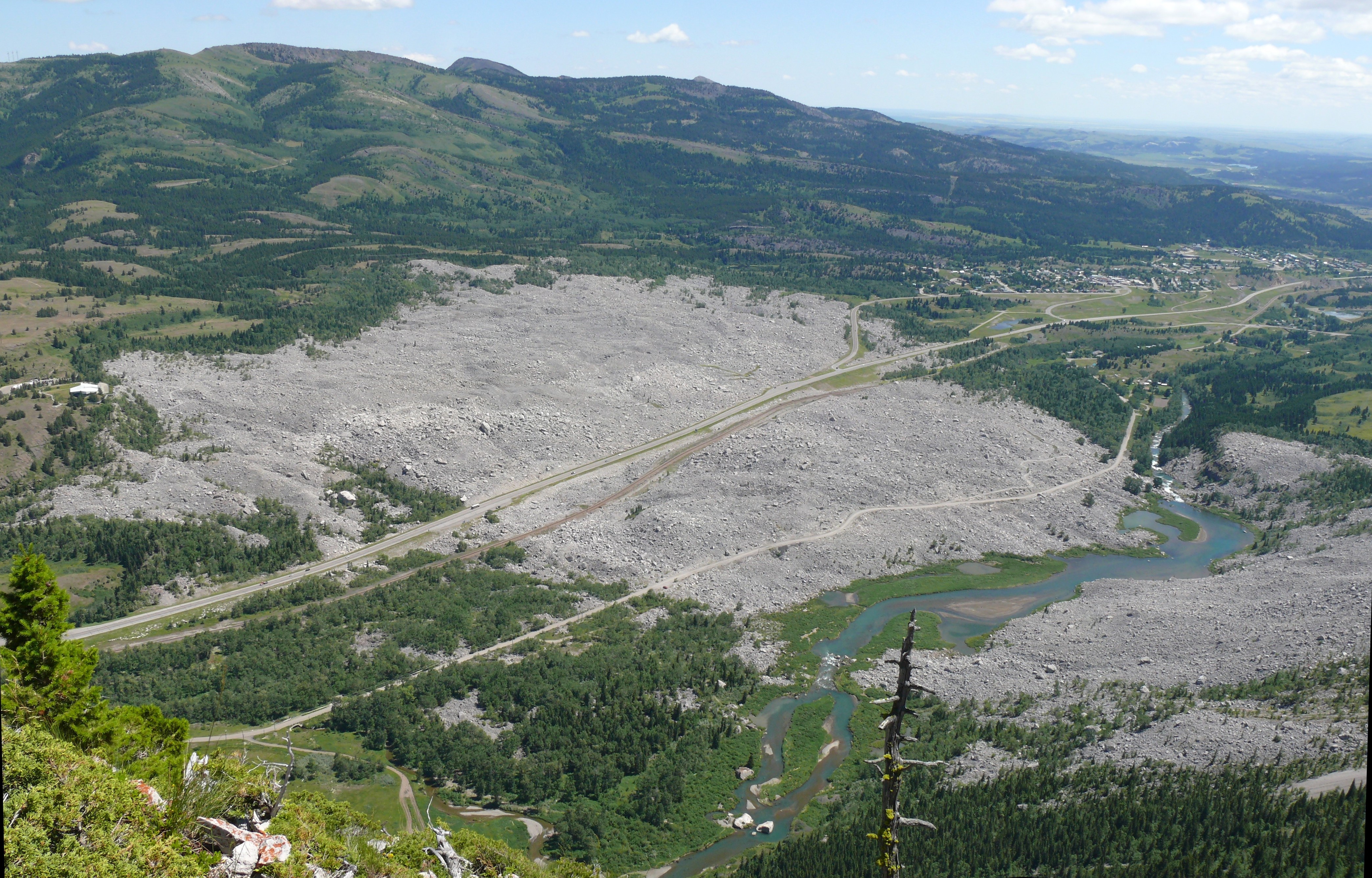
From the Air
Located at 49.59°N, 114.40°W in the Crowsnest Pass of the Canadian Rockies. From altitude, the Frank Slide is unmistakable - a massive grey debris field spreading across the valley floor, contrasting with the green forest on either side. The scar on Turtle Mountain's east face is clearly visible. Highway 3 threads through the debris. The town of Frank (rebuilt) is west of the slide. The Crowsnest River valley stretches east toward the prairies. The Rocky Mountains rise to the west. The debris field covers about 3 square kilometers - one of the most visible rockslide deposits in North America.