Franz Josef Glacier
In Maori tradition, a woman named Hine Hukatere loved climbing in the mountains. She persuaded her partner, Wawe, to climb with her, but he fell to his death from a peak. Hine Hukatere wept so copiously that her tears froze into a river of ice. The glacier's official Maori name - Ka Roimata o Hine Hukatere, the frozen tears of Hine Hukatere - carries that grief into the present tense. Its European name carries different freight: German geologist Julius von Haast named it in 1865 for Emperor Franz Joseph I of Austria, a man who never saw New Zealand and whose empire no longer exists. The glacier endures under both names, a 12-kilometer tongue of ice pushing down from the Southern Alps through temperate rainforest on the West Coast of the South Island, stubbornly persisting in a latitude where glaciers have no obvious right to survive.
Anatomy of Defiance
Franz Josef Glacier exists because of geometry. Its neve - the compacted snowfield at its head - sits over 2,500 meters above sea level, spanning 20 square kilometers and packing more than 300 meters of depth. All that accumulated snow funnels into a steep, narrow valley that drops to 300 meters elevation in just 11 kilometers. The gradient is so aggressive that the ice moves faster than almost any glacier on Earth, flowing through a valley that should, by rights, be filled with subtropical rainforest. And it is - on both sides. The glacier shares its valley with tree ferns and broadleaf forest, a juxtaposition so rare that it anchors the Te Wahipounamu World Heritage Site. Eighteen thousand years ago, at the peak of the last ice age, the glacier reached the present-day coastline. Today it terminates 19 kilometers inland, but Lake Wombat - a kettle lake 9,000 years old - and Peters Pool, formed just 210 years ago, mark the stages of its long retreat like cairns on a trail.
The Glacier That Grew
Between 1983 and 2008, while climate scientists documented glacier retreat worldwide, Franz Josef advanced. Not tentatively - it surged forward 1,420 meters, regaining nearly half the ice it had lost over the previous century. The advance baffled casual observers but not glaciologists, who attributed it to a series of cool years driven by increased southerly airflow in the Tasman Sea. Because the glacier is short and steep, it responds to snowfall changes faster than longer, flatter glaciers. More snow in the neve, more ice flowing downhill, more advance at the terminal face. The cycle played out visibly from St James Anglican Church in the valley below: built in 1931 with a panoramic altar window framing the glacier, the church lost its view by 1954 as the ice retreated. By 1997, the glacier had crept back into the frame. After 2008, however, the retreat resumed with startling speed - 1.5 kilometers lost between 2008 and 2017, erasing the gains and then some. The glacier is now 3 kilometers shorter than it was a century ago.
Reading the Rock Garden
Every surface the glacier abandons becomes an experiment in ecological succession, and the park preserves the results in chronological order. Walk the valley and you move through time: bare rock exposed a decade ago, scrubby pioneer plants on surfaces from 1951, established shrubland on ground the ice left in 1830, and mature podocarp forest on terrain exposed since the 1600s. Westland Tai Poutini National Park is one of the few places in New Zealand with a complete, unbroken ecological gradient from alpine peaks to the Tasman Sea, and the glacier's retreat has created a living laboratory documenting how forest reclaims stone. The process is slow by human standards but fast by geological ones - within a few centuries, bare moraine becomes dense forest indistinguishable from the ancient stands surrounding it.
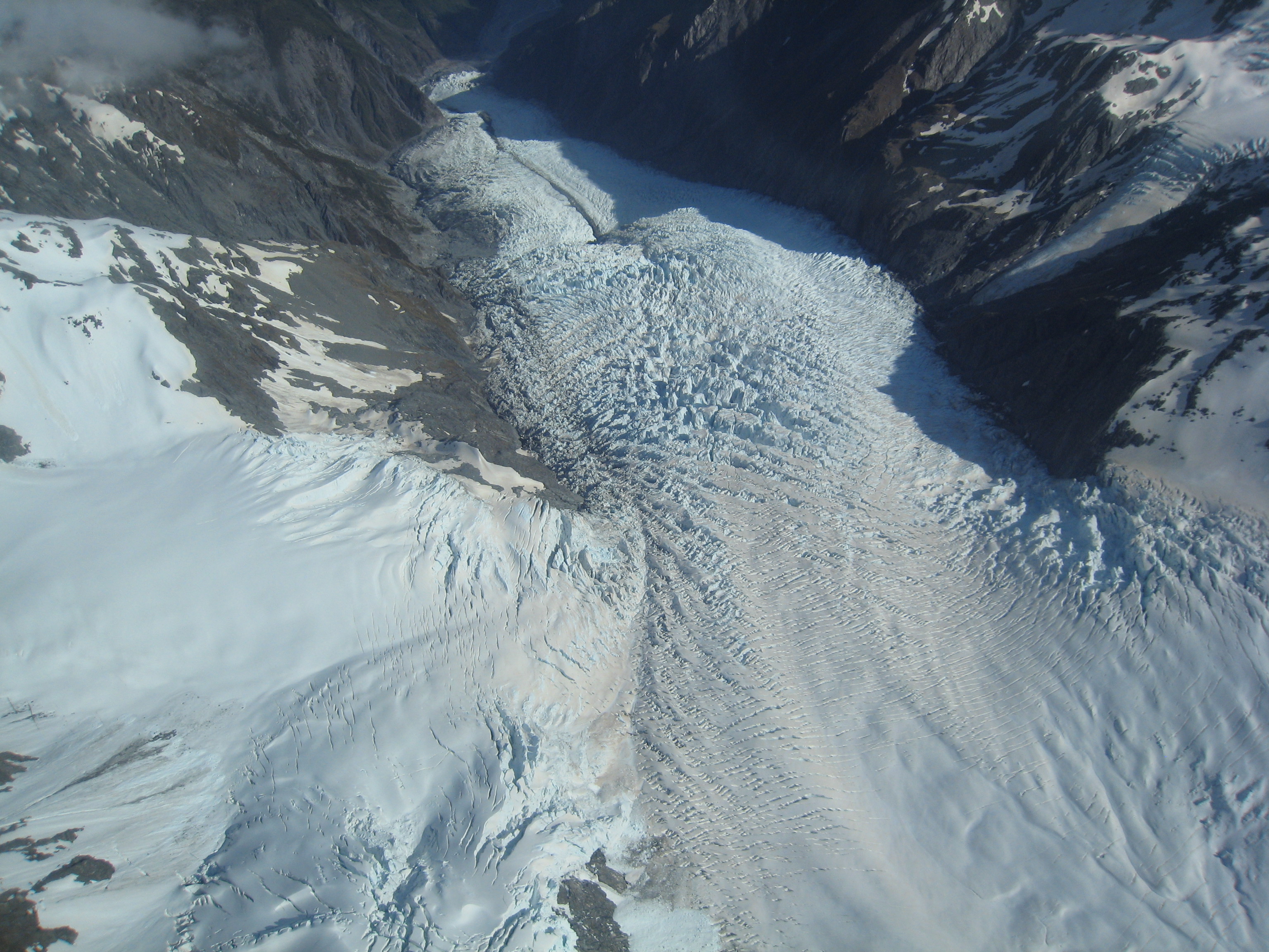
Approaching the Ice
Walking up to Franz Josef Glacier used to be straightforward. As recently as the mid-20th century, visitors could drive nearly to the terminal face. That changed in March 2012 when the terminal face collapsed, making approach on foot too dangerous. Today, signs warn against crossing safety barriers at the valley lookout, and reaching the ice itself requires a helicopter flight - the unstable lower glacier has made the old walking routes untenable. From the air, the scale becomes visceral: crevasses deep enough to swallow buildings, seracs the size of houses, and the eerie blue light that compressed ice produces. Tour helicopters typically land between the first and second icefalls for guided walks across the broken surface, where the landscape shifts almost daily as the glacier flows and fractures. The Alex Knob Track offers a terrestrial alternative - an 8-hour climb gaining 1,100 meters to a viewpoint 1,303 meters high, overlooking the entire glacier valley. Start early; clouds tend to swallow the view by afternoon. Below the glacier, the village of Franz Josef houses about 330 permanent residents but accommodates up to 2,000 visitors nightly during peak season.
From the Air
Located at 43.48°S, 170.20°E on the West Coast of New Zealand's South Island. The glacier flows west from the Southern Alps Main Divide, descending from over 2,500 m to approximately 300 m elevation. From the air, look for the distinctive white ice tongue cutting through dense green rainforest - the contrast is unmistakable on clear days. The village of Franz Josef sits 5 km from the glacier terminal, with a busy heliport serving scenic glacier flights. Hokitika Airport (NZHK) is roughly 130 km north along State Highway 6. Fox Glacier lies 20 km to the south. Weather is notoriously changeable: the West Coast receives extreme precipitation (up to 11 m/year in the mountains), and cloud can obscure the glacier and surrounding peaks rapidly, especially in afternoon. Morning flights offer the best visibility. Aoraki / Mount Cook (3,724 m) rises just east of the Main Divide, and its summit is often visible from the glacier neve.