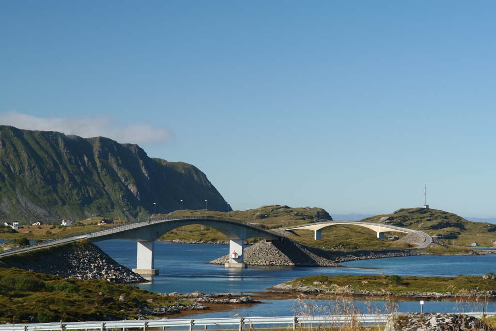
Fredvang Bridges
Before 1988, the fishing village of Fredvang was reachable only by boat. Perched on the island of Moskenesøya in the Lofoten archipelago, its inhabitants lived with the particular isolation that comes from being able to see the neighboring island of Flakstadøya but not drive to it. Then Norway built two bridges -- identical twins, each 240 meters long, leaping in matching cantilever arcs across the straits -- and Fredvang became connected to the road network that threads the entire Lofoten chain. What the engineers built for transportation, photographers and travelers have since claimed as one of the most dramatic drives in the Arctic.
Twin Spans
The Fredvang Bridges are a pair: the southern Kubholmleia Bridge and the northern Røssøystraumen Bridge. Each stretches 240 meters with a cantilevered center span of 115 meters, an engineering solution that allows the bridges to cross open water without support columns disturbing the seabed below. The cantilever design was a practical choice for the conditions -- deep water, strong currents, and the violent weather that characterizes this stretch of coast. Building conventional pier-supported bridges would have been far more expensive and disruptive in the marine environment. The result is a pair of elegant, arching structures that appear almost to float above the water, their clean lines a striking counterpoint to the jagged mountain terrain on either side. The only other bridge linking Moskenesøya to Flakstadøya is the Kåkern Bridge, making these crossings essential arteries for the communities they serve.
The Road Between Islands
Lofoten is an archipelago laced together by bridges, tunnels, and ferry routes. The Fredvang Bridges are part of this larger project of connection -- a Norwegian determination, pursued over decades, to link its remote island and fjord communities by road. Before the bridges, Fredvang's fishermen and families relied on the sea for every trip to a store, a school, or a hospital on the neighboring island. The 1988 opening transformed daily life in ways that are easy to understate. A bridge is infrastructure, but for a fishing village above the Arctic Circle, it is also an argument that the community deserves to persist. The road the bridges carry now continues as part of the scenic routes through Lofoten, winding between peaks and fjords in a landscape that makes the driving itself a destination.
A Photographer's Crossing
The Fredvang Bridges have become one of Lofoten's most recognizable images. Seen from above or from the surrounding hillsides, the two parallel arcs of concrete and steel trace graceful curves across water that shifts between deep blue and green depending on the light. Behind them, Lofoten's signature peaks rise in sharp silhouette. The bridges photograph beautifully in every season: dusted with snow against a winter aurora, gleaming in the midnight sun of June, or shrouded in the dramatic cloud banks that roll off the Norwegian Sea. For aerial observers, they are unmistakable -- two matching white lines drawn across dark water between mountainous islands. They are a reminder that in Lofoten, even the infrastructure participates in the scenery. What was built to solve a problem of isolation has become, almost accidentally, a landmark.
From the Air
Located at 68.08°N, 13.19°E, connecting Moskenesøya and Flakstadøya in the Lofoten archipelago. The two parallel bridge spans are clearly visible from the air as white arcs crossing the strait between the islands. Best viewed at 1,500-3,000 ft for bridge detail against the mountain backdrop. Nearest airport: Leknes Airport (ENLK), approximately 30 km northeast. Bodø Airport (ENBO) provides the main mainland connection. The bridges are part of the E10 scenic highway route through Lofoten. Surrounding peaks and fjords provide excellent visual landmarks for navigation.