Free Territory of Trieste
It had its own postage stamps. It participated in the Marshall Plan as a sovereign state. It even sent a cycling team to the 1950 Peace Race in Poland. But the Free Territory of Trieste, established on September 15, 1947, never managed to appoint a governor, never held national elections, and never really functioned as the independent country the United Nations had intended it to be. For seven years, this narrow crescent of Adriatic coastline between Italy and Yugoslavia existed in a diplomatic limbo that said more about the emerging Cold War than about the people who actually lived there.
The Fault Line
The territory that became the Free Territory of Trieste had been contested ground for centuries. Since 1382, Trieste belonged to the Habsburgs, while neighboring Istria was split between Habsburg and Venetian control. Italian speakers dominated the cities and the coast; Slovenes and Croats populated the countryside and the hills. After World War I dissolved Austria-Hungary, Italy annexed the entire region, creating the border district known as the Julian March. Under Mussolini's fascist regime in the 1920s and 1930s, the Slavic population endured forced Italianization, discriminatory policies, and outright violence -- including the burning of the Slovene National Hall in Trieste on July 13, 1920. Some Slovenes and Croats emigrated to Yugoslavia; others joined the TIGR resistance, which carried out over a hundred bombings and assassinations against Italian authorities.
Two Armies, One City
The end of World War II brought a new crisis rather than a resolution. When Nazi Germany's front collapsed in April 1945, Yugoslav Partisan forces under Tito raced to take Trieste, entering the city on May 1. New Zealand's 2nd Division arrived the following day, accepting the surrender of 2,000 German troops who had refused to capitulate to the Yugoslavs for fear of reprisals. For weeks, Yugoslav and Allied soldiers occupied the same streets in an uneasy standoff. British General William Morgan proposed splitting the region into military zones, and Tito agreed on May 23. The Morgan Line was drawn: Zone A, including Trieste and its port, went under British and American administration; Zone B, covering northwestern Istria, fell to Yugoslavia. The partition was signed at Duino on June 10, 1945.
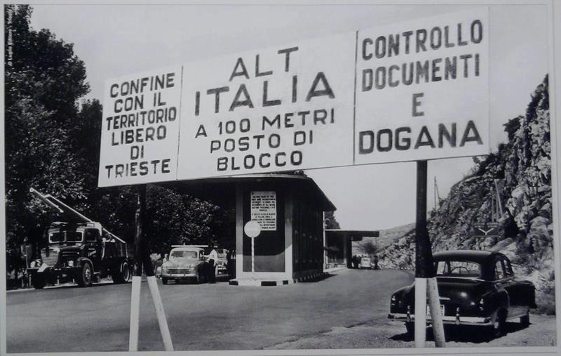
A Country Without a Captain
In January 1947, the UN Security Council passed Resolution 16 calling for a free state in the Trieste region, and the Treaty of Peace with Italy formalized it that September. Official languages were Italian and Slovene. The territory covered 738 square kilometers with roughly 330,000 inhabitants. But the mechanism required agreement among four powers -- the United States, United Kingdom, France, and the Soviet Union -- on a civilian governor. Between October 1947 and March 1948, Moscow rejected twelve consecutive nominees. With no governor, no national legislature, and no real sovereignty, the territory drifted. Zone A was administered by 5,000 American troops of the Trieste United States Troops (TRUST) and 5,000 British personnel of BETFOR. Zone B operated under Yugoslav military authority. Elections were held only twice, in 1949 and 1952, and only for municipal councils.
The Quiet Dissolution
The Tito-Stalin split of 1948 scrambled the geopolitics further. With Yugoslavia suddenly estranged from the Soviet bloc, the Western proposal to return the territory to Italy was shelved. The stalemate held until October 5, 1954, when the London Memorandum effectively dissolved the Free Territory: Zone A went to Italy, Zone B to Yugoslavia. Thousands of Italians from Zone B chose to leave, calling themselves esuli -- exiles. About 14,000 Italians stayed. The border dispute between Italy and Yugoslavia was not formally settled until the Treaty of Osimo in 1975, ratified in 1977. When Yugoslavia itself dissolved in the early 1990s, Zone B was divided between Slovenia and Croatia. The Free Territory of Trieste, conceived as a neutral buffer, had been absorbed by the very nations it was designed to keep apart.
Borders Visible from Above
From the air, the former Free Territory stretches along the Gulf of Trieste from Duino in the north to what is now Novigrad in Croatia to the south. The landscape shifts from the pale limestone of the Karst plateau to the green hills of Istria, with the Adriatic curving westward toward Venice. Trieste's port -- which held free-zone status dating to 1719 and confirmed by the 1947 treaty -- still operates under special international terms recognized by the European Union. The borders that the Morgan Line drew through this landscape in 1945 are now the frontiers of three nations, and the territory's brief, strange existence as an unborn country has left almost no visible trace on the ground.
From the Air
Located at 45.68N, 13.75E, the former Free Territory stretched along the Gulf of Trieste from Duino (45.77N) in the north to Novigrad (45.32N) in the south. The territory spanned 738 square kilometers between modern Italy, Slovenia, and Croatia. Recommended viewing altitude: 10,000-15,000 feet to see the full extent of the former territory along the Adriatic coast. Nearest airports: Trieste-Friuli Venezia Giulia Airport (LIPQ) in Zone A, and Portoroz Airport (LJPZ) in what was Zone B. The Karst plateau and Istrian hills provide clear geographic framing.