Fuji Five Lakes: The View on the Thousand-Yen Note
Reach into your pocket in Japan, pull out a thousand-yen note, and flip it over. The image of Mount Fuji reflected in still water comes from a photograph taken on May 2, 1935, by Okada Koyo at Lake Motosuko -- the deepest and westernmost of the Fuji Five Lakes. Okada climbed to the Nakanokura-touge mountain pass on the lake's northwestern shore, waited for the light, and captured a scene so perfectly composed that the Japanese government put it on their currency. Today, visitors still climb to the same spot and hold up the banknote to compare. The mountain has not moved. The lake has not changed. The Fuji Five Lakes region, known locally as Fujigoko, sits at roughly 1,000 meters above sea level on Mount Fuji's northern flank, and everything here -- the water, the land, the towns -- exists because the volcano shaped it.
Lava, Water, and the Making of Five Lakes
The five lakes did not exist before Mount Fuji made them. Ancient eruptions sent rivers of lava cascading down the mountain's northern slopes, damming rivers and pooling meltwater into basins that became lakes. Each one is distinct. Lake Yamanakako, the largest, sits at 980 meters above sea level -- making it the third-highest lake in Japan -- and lies closest to Fuji's summit, offering unobstructed views of the mountain's entire eastern face. Lake Kawaguchiko, the most accessible and developed, serves as the region's transportation hub. Lake Saiko, barely a kilometer from Kawaguchiko, remains almost undeveloped, a quiet refuge for fishing and camping. Lake Shojiko, the smallest, was once called the Switzerland of East Asia by visiting Englishmen struck by its mountain-framed beauty. And Lake Motosuko, at 121.6 meters deep, is the deepest of the five and the ninth-deepest lake in Japan.
Three Lakes, One Heartbeat
Something strange connects three of the five lakes. Saiko, Shojiko, and Motosuko share the same surface elevation -- 900 meters above sea level -- and they hold that level with uncanny consistency. The reason lies underground. Subterranean waterways, carved through the porous volcanic rock by centuries of seepage, link the three lakes in a hidden plumbing system. When one rises, the others follow. The connection is invisible from the surface, but it means these three bodies of water are, hydrologically speaking, one system wearing three faces. The volcanic geology that created the lakes also created the region's other famous features: the hot springs, or onsen, that draw visitors year-round, and the lava caves and forests that riddle the mountain's lower slopes, including the dense and somber Aokigahara Forest on Fuji's northwestern base.
A Thousand Meters of Living
The Fuji Five Lakes region supports a population of about 100,000 people living in the shadow of the most famous mountain on Earth. Fujiyoshida, the principal city with roughly 54,000 residents, is famous throughout Japan for its thick, hand-made udon noodles -- a hearty style born from the cool highland climate where wheat once thrived better than rice. The region's attractions range from contemplative to exhilarating: Fuji-Q Highland, an amusement park on the lakeshore, features some of the world's most extreme roller coasters, while the Village of Healing -- Iyashinosato -- is a meticulously reconstructed traditional Japanese village where visitors walk through thatched-roof houses and workshops. In 1927, the Tokyo Nichi Nichi Shimbun and the Osaka Mainichi Shimbun newspapers selected the Fuji Five Lakes as one of Japan's Twenty-Five Winning Sites, an honor that helped establish the region as a destination rather than merely a waypoint on the road to the summit.
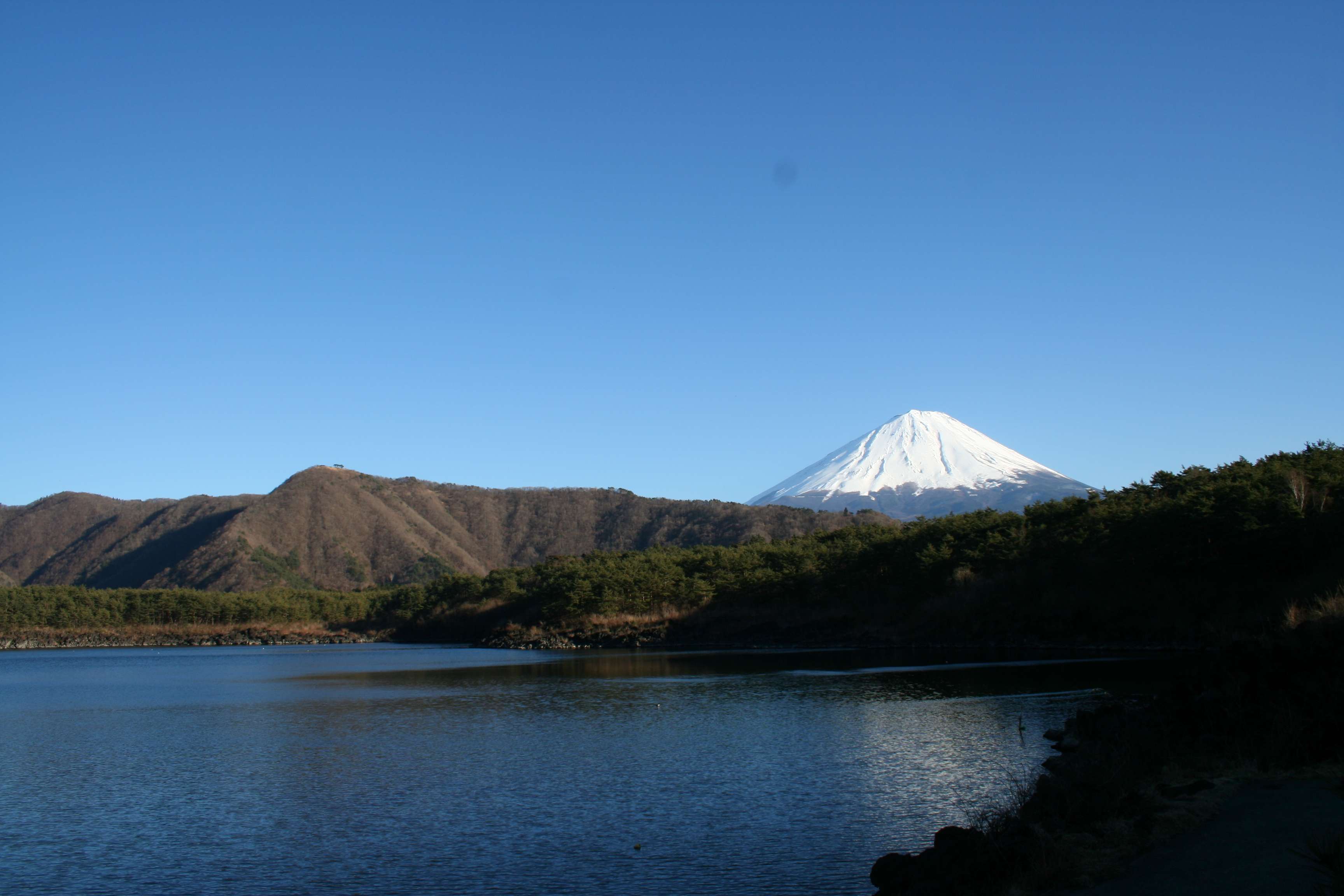
The Mountain in the Mirror
What draws people to the Fuji Five Lakes, more than the hot springs or the roller coasters or the noodles, is the view. Mount Fuji is visible from Tokyo on clear days, but from the Five Lakes, the mountain is not a distant silhouette -- it is the entire sky. Each lake offers a different perspective. Yamanakako gives the widest panorama, the full sweep of the cone from base to summit. Kawaguchiko frames Fuji behind cherry blossoms in spring and autumn maples in November. Motosuko provides the banknote view, the one Okada Koyo immortalized -- Fuji reflected perfectly in the deep, still water, unchanged since 1935. The region sits within Fuji-Hakone-Izu National Park, and from the air, the five lakes arc across the mountain's northern base like a necklace of blue stones set against volcanic black and forest green, each one catching the light of the mountain that made it.
From the Air
Located at approximately 35.416N, 138.871E at the northern base of Mount Fuji in Yamanashi Prefecture. The five lakes are clearly visible from altitude, arcing across Fuji's northern flank: Yamanakako (easternmost and largest), Kawaguchiko (most developed), Saiko, Shojiko (smallest), and Motosuko (westernmost and deepest). Best viewed at 5,000-10,000 feet AGL for the full panorama of the lakes against Mount Fuji. The region sits at approximately 3,000 feet MSL. Mount Fuji (12,388 feet) dominates the southern horizon. Nearest airport is Mount Fuji Shizuoka Airport (RJNS) approximately 45 nautical miles south-southwest.