Fukui Prefectural Varve Museum
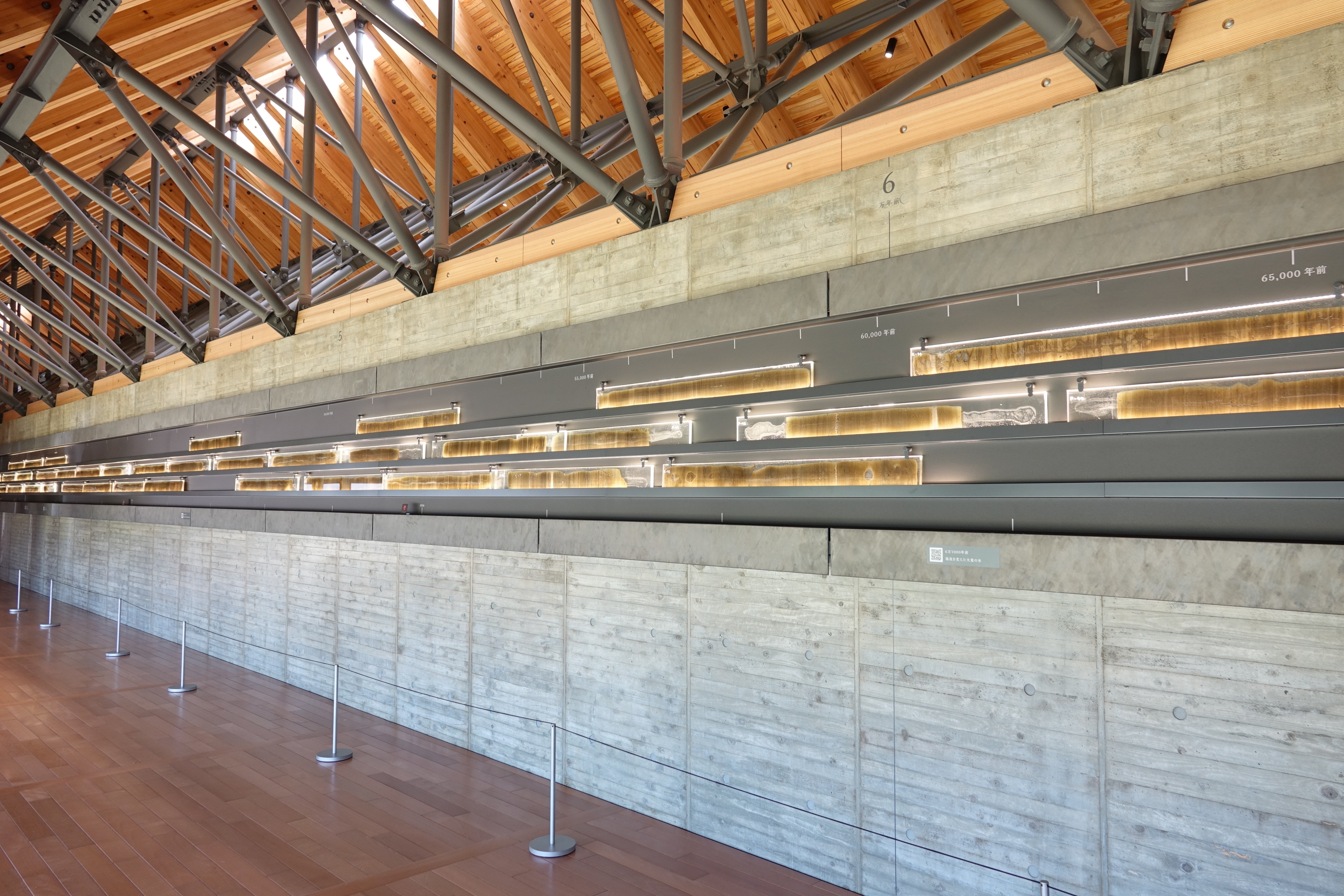
Every year for 160,000 years, a thin layer of sediment settled to the bottom of Lake Suigetsu. Spring brought light-colored diatom blooms. Autumn delivered darker mineral particles. Year after year, light-dark, light-dark, the layers accumulated like pages in a book that no one was writing and no one would read -- until scientists drilled down 70 meters into the lakebed and pulled up the most precise geological calendar ever discovered. The Fukui Prefectural Varve Museum exists to display that calendar: 45 meters of razor-thin sediment sliced open, embedded in epoxy, and stretched along the museum walls like a timeline you can walk beside.
The Miraculous Accident
Lake Suigetsu is the largest of the Five Lakes of Mikata in Fukui Prefecture -- a brackish body of water covering just over four square kilometers, with a maximum depth of 34 meters. On its own, the lake is unremarkable. What makes it extraordinary is a combination of geological accidents so unlikely that Japanese scientists call the result "Miraculous Sediments." No rivers flow directly into the lake, so nothing disturbs the precipitate on the bottom. The deep water is completely devoid of oxygen, meaning no organisms burrow through the sediment. And a geological fault running beneath the lake slowly lowers its bed over time, ensuring it never fills up with deposits. Each condition alone would be merely interesting. Together, they produced an unbroken record of annual sediment layers -- varves -- reaching back 160,000 years.
Drilling for Time
Scientists first investigated Lake Suigetsu's sediments in 1991. The breakthrough expedition came in 2006, when researchers faced a practical problem: a 70-meter core of soft sediment cannot be extracted as a single continuous column. So they drilled at four different spots, pulling up one-meter sections at a time, then painstakingly matched the varve patterns between cores to reconstruct the complete sequence. The result, designated SG06, was a 70-meter-long record with no gaps -- 160,000 years of continuous deposition. An international team from Japan, the United Kingdom, and Germany then measured the ratio of radiocarbon to stable carbon isotopes throughout the layers, producing calibration data spanning 11,200 to 52,800 years ago. The margin of error was roughly 170 years across 50,000 -- staggering precision for geological science.
The World's Clock
On July 13, 2014, at a conference held at UNESCO headquarters in Paris, the international scientific community made it official: the Lake Suigetsu varve data would serve as the world's de facto standard for radiocarbon dating calibration. Every archaeologist dating a campfire, every paleoclimatologist aging a fossil, every geologist trying to pin down when a volcano erupted now relies on the sediment record from this small lake in rural Fukui Prefecture. The data published in the journal Science provided the first complete terrestrial radiocarbon record for the period, replacing less reliable marine-based calibrations that had served as the global benchmark for decades.
Reading Earth's Diary
The museum sits within Jomon Roman Park in the town of Wakasa, near the shore of Lake Mikata at the mouth of the Hasu River. Its centerpiece is a 45-meter-long thin section of varve embedded in epoxy and displayed along the gallery walls. Walking beside it, visitors pass through millennia with each step -- volcanic ash layers from the eruption of Kikai Caldera punctuate the sequence like bookmarks. Other exhibits decode what the varves reveal about paleoclimate around the lake, display varve samples from other locations around the world, and explain the science of archeoclimatology. The museum shares its park with the Wakasa Mikata Jomon Museum, and a joint ticket covers both. Reaching it requires a 20-minute walk from Mikata Station on the JR Obama Line -- a small journey to see the instrument that set the world's geological clock.
From the Air
Located at 35.559N, 135.897E in the town of Wakasa, Fukui Prefecture, within Jomon Roman Park near the shore of Lake Mikata. The Five Lakes of Mikata are visible from altitude as a cluster of connected water bodies along the coast of Wakasa Bay. Lake Suigetsu, where the varve sediments were extracted, is the largest of the five. Nearest airport: Komatsu Air Base/Komatsu Airport (RJNK) approximately 80km to the northeast. The coastline of Wakasa Bay and the lake cluster provide clear visual landmarks for navigation. Expect maritime weather influence with sea fog possible in morning hours.