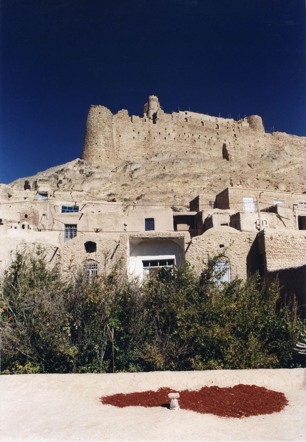
Furg Citadel
Nobody can agree on where the name comes from. The Dehkhoda Dictionary says "Fork" was an ancestral Iranian name. Other accounts claim it belonged to the daughter of an Indian king, or to the wife of the Sassanid ruler Bahram Gour. Still others trace it to a founder named Mozafar Keyghobad, whose village was first called Pourg, then Fork, then Forg, the syllables shifting across centuries like sand drifting across the Darmian Valley floor. What everyone does agree on is the citadel. Furg Citadel sits at 1,840 meters on the northern edge of the village, overlooking the valley that opens onto the Asadiyeh plain, and it has been the center of power, refuge, and argument in this corner of South Khorasan for nearly three hundred years.
Built in the Shadow of Nader Shah
Construction began around 1160 AH -- roughly 1747 CE -- during the reign of Nader Shah Afshar, the last great military conqueror of the Iranian plateau. The citadel was started by Mirza Bagha Khan and completed by his son, the Second Mirza Rafi Khan, whose name became synonymous with the fortress itself. But even the family chronicle, the Divan-e-Lame, hedges its account: "Was it really started by Mirza Bagha Khan, or is it one of the old buildings where everyone has had a hand in repair and completion?" The honest answer appears to be that nobody knows for certain. What is clear is that by the time European travelers began passing through Khorasan in the early 19th century, Furg Citadel was formidable enough to draw detailed descriptions from foreign military officers assessing the region's defenses.
A Fortress Engineered for Siege
Covering 9,200 square meters, the citadel was designed around three functional zones that followed the traditional Iranian model: the Kohandej, where the ruler lived; the Sharestan, where the villagers sheltered; and the Rabath, encompassing the surrounding farms and gardens. The first section held barns, living quarters for staff, cattle pens, guard towers, and water storage. The second rose as a tall central mass, housing armories and barracks, crowned by a brick tower decorated with cruciform and lozenge patterns. The third section, on the western end, comprised two floors overlooking the village roads, separated from the center by fortified walls and twin towers. Colonel MacGregor, visiting in 1875, noted that three water reservoirs inside could supply a large garrison for a year and a half -- a remarkable feat of engineering in a landscape where water is precious and siege was a genuine possibility.
The Tunnel and the Escape
Beneath the citadel runs a tunnel with approximately 100 usable stairs. Local tradition holds that it was used during a battle between Mirza Rafi Khan and the forces of Mir Alam Khan and his son Amir Asadollah Khan. The chronicle Einolvaghayeh records the moment with vivid specificity: Esmaeil Khan, Atakhan, and their families submitted and followed, while the Afghans with Mirza Rafi Khan and Haji Fathkhan Afghan "erected a burrow on one side of the citadel and escaped at night." Whether this tunnel was dug during the battle itself or merely exploited during it remains uncertain -- boring a passage through rock takes time that a siege rarely allows. The more likely explanation is that the tunnel predated the conflict, perhaps built during the citadel's original construction as a standard escape route, the kind of feature that separates a serious fortification from a decorative one.
European Eyes on Khorasan
The first known European description of Furg Citadel came from a Doctor Forbes in 1814, during a period when the Great Game was drawing British and Russian attention deep into Central Asian geography. Forbes noted the citadel's position atop a hill at 2,000 to 2,500 feet, vulnerable to fire from highlands to the north and west but otherwise commanding. Colonel MacGregor quoted Forbes in his itinerary "A Journey to the Province of Khorasan" and added his own observations about the water storage capacity. A traveler identified as Khanykf and another named Blue also left accounts. These European visitors were not tourists -- they were intelligence officers and diplomats mapping terrain for empires that saw Khorasan as a chessboard. Their descriptions survive as some of the most detailed records of the citadel's condition before the 20th century.
What Mud Brick Leaves Behind
Archaeological excavations in 2001 confirmed much of what the chronicles suggested: stables, food storage areas, burrows, and corridors linking the citadel's sections were identified beneath the weathered walls. The evidence pointed to the Afsharid era as the primary construction period, though the question of whether Furg might be an older Ismaili fortress remains open. Ismaili citadels were typically built in remote, hidden locations -- a description that fits Furg's position at the edge of a mountain valley. Today the citadel is registered on Iran's List of National Works, a designation it received on 18 March 2001. The mud-brick walls still stand against the Khorasan sky, their towers and embankments slowly yielding to the same dry wind that once carried the name of this place from Pourg to Fork to Forg to Furg, each generation reshaping the word as it reshapes the walls.
From the Air
Furg Citadel is located at 32.845N, 59.948E in South Khorasan province, eastern Iran, at an altitude of 1,840 meters. From the air, look for a hilltop fortification on the northern edge of a small village at the entrance to the Darmian Valley. The citadel is approximately 12 miles from Birjand, which has the nearest major airport -- Birjand Airport (OIMB). The terrain is mountainous and semi-arid; the Asadiyeh plain stretches to the east. Visibility is generally good but dust conditions can occur.