Gamboa, Panama
The road to Gamboa ends at the jungle. A single lane crosses a narrow bridge, and then there is a town that time has been slowly reclaiming since the Americans left. Houses stand empty along streets named for canal engineers. The swimming pool is quiet. The commissary has been boarded up for decades. But at dawn, Pipeline Road fills with birders carrying spotting scopes and life lists, because Gamboa sits at the intersection of the Panama Canal and one of the most biodiverse tracts of rainforest in Central America.
Built on Drowned Towns
Present-day Gamboa was constructed in 1911 on a sharp bend of the Chagres River, near the point where it feeds Gatun Lake. The town rose near the site of the old village of Santa Cruz, three miles downstream from Las Cruces -- the colonial-era river port where travelers and cargo once disembarked from barges to take the overland mule trail to the Pacific. Its first residents were not Americans but roughly 700 "silver roll" workers -- Afro-Antillean laborers and other non-U.S., non-white canal employees -- displaced from the former towns of Tabernilla and Gorgona, which were flooded as Gatun Lake rose. By 1914, when canal construction wound down, Gamboa's population had shrunk to 173 people living in a police station, two repurposed houses hauled in from abandoned towns, and several old railroad boxcars.
The Dredge Workers' Town
Gamboa's real life began in 1936, when the Panama Canal Company relocated its Dredging Division from the town of Paraiso. Within a year, the population leapt from 251 to 1,419, and by 1942 it peaked at 3,853. The new residents built their own civic center with their own hands and funds -- the men hammering, sawing, and pouring concrete while the women brought picnic lunches and tended barbecues. They opened the Gamboa Golf and Country Club on January 1, 1939, on the ridge overlooking the Chagres, complete with a nine-hole golf course. The town eventually had five churches, a commissary, a post office, a school, a fire station, and a movie theater. It also had a segregated section called Santa Cruz, where non-white, non-U.S. families lived separately. In October 1954, fifty families were moved to Santa Cruz from La Boca when that town was depopulated and converted into a whites-only housing area.
Slow Unraveling
Because Gamboa sat at the end of a single road, far from other Canal Zone towns, it was considered the least desirable posting. Housing was assigned by seniority, so newcomers to the Zone often landed here first, waiting for transfers to better-connected communities. After the 1977 Panama Canal Treaties began transferring operations to Panama, services disappeared one by one. The commissary and movie theater were boarded up through the 1980s. The Panama Railroad, which had once connected Gamboa to the broader canal infrastructure, ceased operations in the late 1980s, cutting the town further adrift. The elementary school, built in 1937 with three paired-grade classrooms, saw enrollment drop from 115 in 1979 to 53 by 1988. That June, with only 40 students projected, the school closed. After the U.S. military operation Just Cause in December 1989, the building briefly served as a headquarters for Military Police.
Where the Pavement Ends and the Canopy Begins
Today Gamboa is inhabited but hollowed out -- a shadow of its peak years, with many houses standing empty and public buildings underutilized. It remains the headquarters of the Panama Canal Authority's Dredging Division, and its docks serve as the embarkation point for ferries to Barro Colorado Island, where the Smithsonian Tropical Research Institute operates one of the world's most important tropical field stations. But the town's real draw is what surrounds it. Caymans, crocodiles, and iguanas share the riverbanks. Several hundred bird species inhabit the adjacent rainforest, making Pipeline Road -- a trail following an old petroleum pipeline -- one of the premier birding sites in all of Central America. The Audubon Society of Panama holds annual bird counts here, drawing amateur birdwatchers and professional ornithologists alike. The Gamboa Rainforest Resort, a five-star hotel, has brought tourists to the otherwise sleepy settlement with an aerial tram through the jungle canopy.
Ghosts and Green Canopy
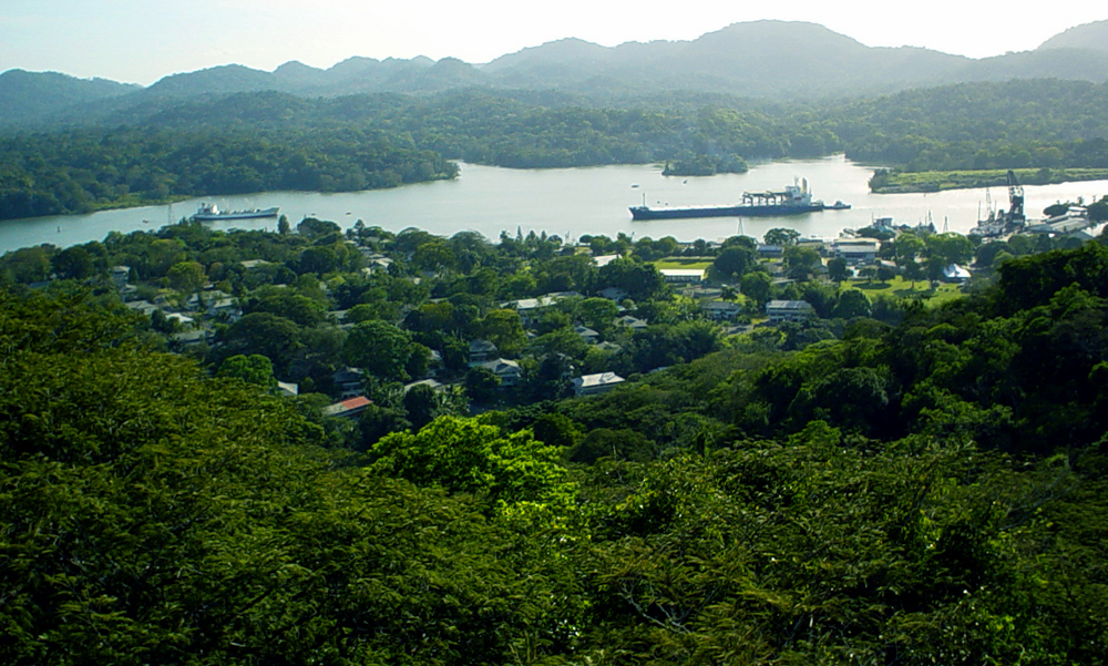
The old Spanish colonial Las Cruces Trail -- the path that once carried precious metals between the Atlantic and Pacific -- passes near Gamboa, though parts of it now lie underwater beneath Gatun Lake. It is a fitting detail for a place where layers of history keep disappearing beneath rising waters and encroaching forest. The golf course became a Boy Scout camp and then went quiet. The school became a police station and then went quiet too. Gamboa's name comes from a tree of the quince family, and trees are slowly winning the contest with concrete here. From the air, the town is a small clearing where the Chagres bends sharply, a grid of rooftops pressed against the green wall of the rainforest, with the canal's shipping channel visible just beyond.
From the Air
Gamboa is located at 9.117N, 79.70W, on a sharp bend of the Chagres River where it feeds Gatun Lake. From the air, the town appears as a small developed clearing surrounded by dense rainforest, with the canal's shipping channel visible nearby. The single-lane bridge into town is a recognizable landmark. Nearby airports include Marcos A. Gelabert International (MPMG) approximately 20 km south and Tocumen International (MPTO) about 50 km southeast. Best viewed at 2,000-4,000 feet to see the town's relationship to the river, lake, and canal.