Geirangerfjord
Seven waterfalls pour simultaneously down one wall of the fjord, side by side like strings on a harp. Across the water, a single waterfall answers them -- the Suitor, according to local legend, forever trying to woo the sisters opposite. This is Geirangerfjord, a 15-kilometer slash through the mountains of western Norway's Sunnmore region, where cliff walls rise so steeply from the water that Magdalene Thoresen -- Henrik Ibsen's mother-in-law -- wrote that the heights "rise in sheer and rugged strata almost straight out of the water." UNESCO inscribed it as a World Heritage Site in 2005, jointly with Naeroyfjorden, under the title "West Norwegian Fjords." The designation was well earned. It was also, as it turns out, precarious.
Farms on the Precipice
What makes Geirangerfjord extraordinary is not just its depth and drama but the evidence of human stubbornness clinging to its walls. Along the fjord's near-vertical sides, a series of now-abandoned farms perch on ledges that seem impossibly narrow. Skagefla, Knivsfla, and Blomberg were once working homesteads, reached by paths that wound around cliff faces and crossed bridges bolted to the rock with iron rings. Thoresen marveled at them in the 19th century, noting that they "bear witness in a most striking way to the remarkable powers of invention which the challenges of nature have developed in man." The Storfjordens venner association has restored several of these farms. Skagefla can be reached on foot from the village of Geiranger; the others require a boat. Standing on one of these ledges, hundreds of meters above the fjord, the ambition and isolation of the people who farmed here becomes visceral.
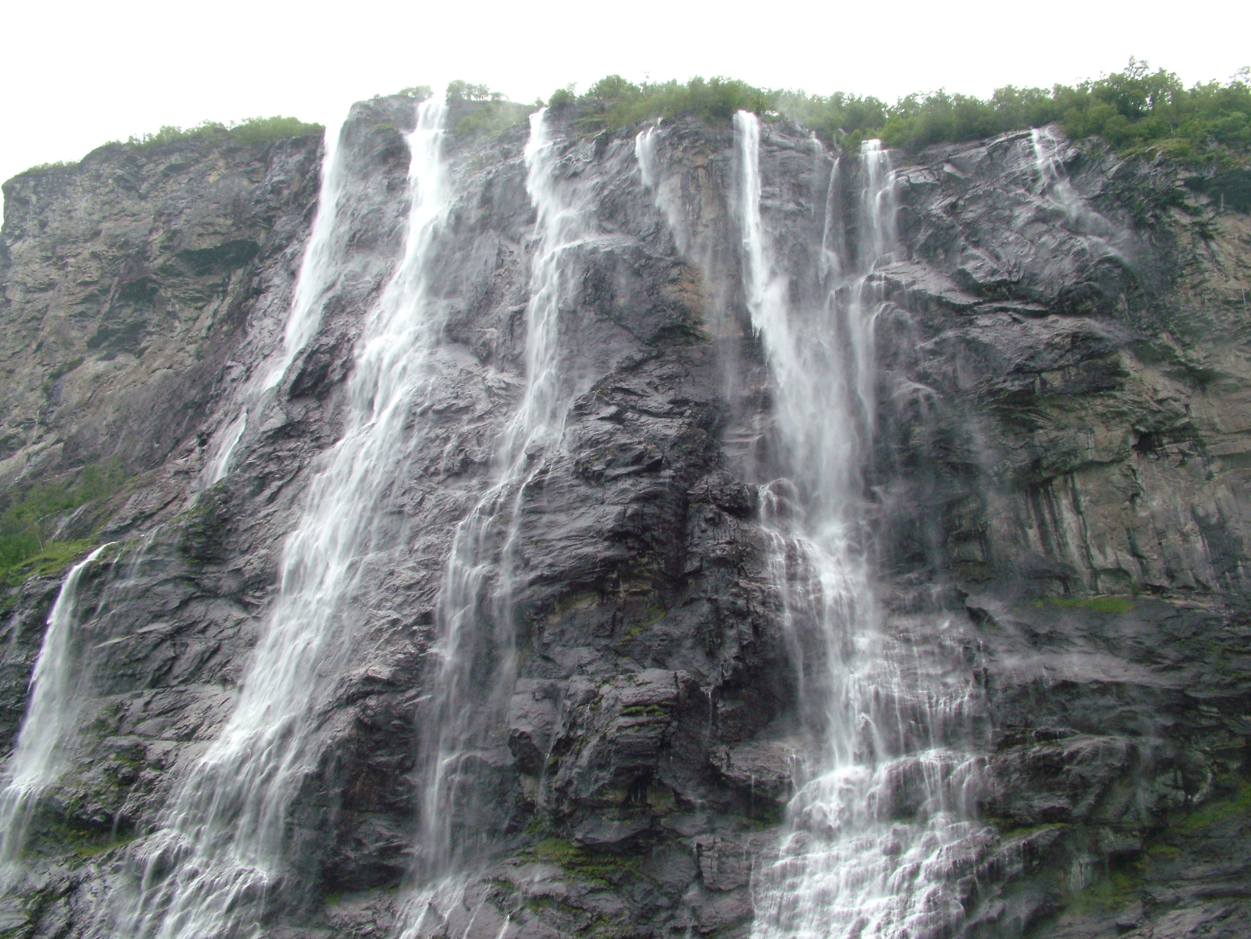
The Sisters, the Suitor, and the Veil
The waterfalls of Geirangerfjord have names that read like characters in a folk tale, because that is exactly what they are. The Seven Sisters Falls cascade down the north wall in seven distinct streams, each fed by snowmelt from the plateau above. Directly across the fjord, the Suitor falls in a single stream -- a rejected lover, the story goes, who took to drink after the sisters spurned him. The shape of the falls is said to resemble a bottle. Further along, the Bridal Veil earns its name on sunny days, when the thin sheet of water catches backlight and turns translucent against the dark rock, as delicate as fabric. The ferry between Geiranger and Hellesylt runs the full length of the fjord, passing directly beneath these falls. Passengers who stand on the open deck get misted by the spray.
The Mountain That Will Fall
Above the fjord's southern shore, the mountain called Akerneset is slowly tearing itself apart. A crack in the rock face has been widening for years, monitored around the clock by geologists. When -- not if -- a large section of Akerneset collapses into the fjord, it will generate a megatsunami. Models estimate the wave could reach 80 meters near the slide zone and would hit the villages of Geiranger and Hellesylt within roughly ten minutes. The 2015 Norwegian disaster film The Wave dramatized exactly this scenario, depicting the destruction of Geiranger by a rock-slide-triggered tsunami. The threat is not hypothetical; similar collapses have struck Norwegian fjords before, most devastatingly at Tafjord in 1934. Early warning systems are in place, and evacuation plans have been drilled, but the mountain's timeline remains its own.
From Frozen to Zero Emissions
Geirangerfjord's dramatic walls served as the visual template for the kingdom of Arendelle in Disney's Frozen, a connection that has drawn a new generation of visitors to a place already among Norway's most popular tourist destinations. The car ferry between Geiranger and Hellesylt doubles as a sightseeing cruise, and during peak summer months the fjord fills with vessels of every size. That traffic has consequences. The Norwegian government has mandated that all ships entering the fjord must be zero-emission by 2026, a regulation designed to protect both the air quality and the UNESCO status that the fjord's fame depends on. Disputed plans to build power lines across the fjord have also threatened its World Heritage listing, forcing a tension between preservation and infrastructure that Norway has not yet fully resolved.
Where the Water Ends
At the head of the fjord, where the Geirangelva river empties into still green water, the village of Geiranger occupies a small delta. It is a hamlet that punches far above its weight -- a handful of hotels, a fjord center, and a dock that receives some of the largest cruise ships in the world. Above the village, the road climbs to Dalsnibba viewpoint at 1,500 meters, and from there the fjord shrinks to a dark ribbon far below, the waterfalls reduced to white threads against grey rock. The scale inverts: what felt immense from water level becomes a crease in the landscape, a reminder that even Norway's most celebrated fjord is only a small incision in a much larger mountain world.
From the Air
Geirangerfjord is located at 62.09N, 7.08E in the Sunnmore region of western Norway. The fjord extends 15 km inland as a branch of Sunnylvsfjorden. From the air, the narrow fjord with its vertical walls, waterfalls, and abandoned cliff farms is unmistakable. The Seven Sisters Falls are on the north wall; the Suitor faces them from the south. The village of Geiranger sits at the fjord's head, Hellesylt at the mouth. Nearest airports: Alesund Airport, Vigra (ENAL) ~85 km west, and Molde Airport, Aro (ENML) ~100 km north. The Dalsnibba viewpoint (1,500m) is visible above Geiranger. Altitude recommendation: 3,000-5,000 ft for the full fjord panorama, or 1,500 ft for waterfall detail. The Akerneset crack on the south wall is monitored but not visible from altitude.