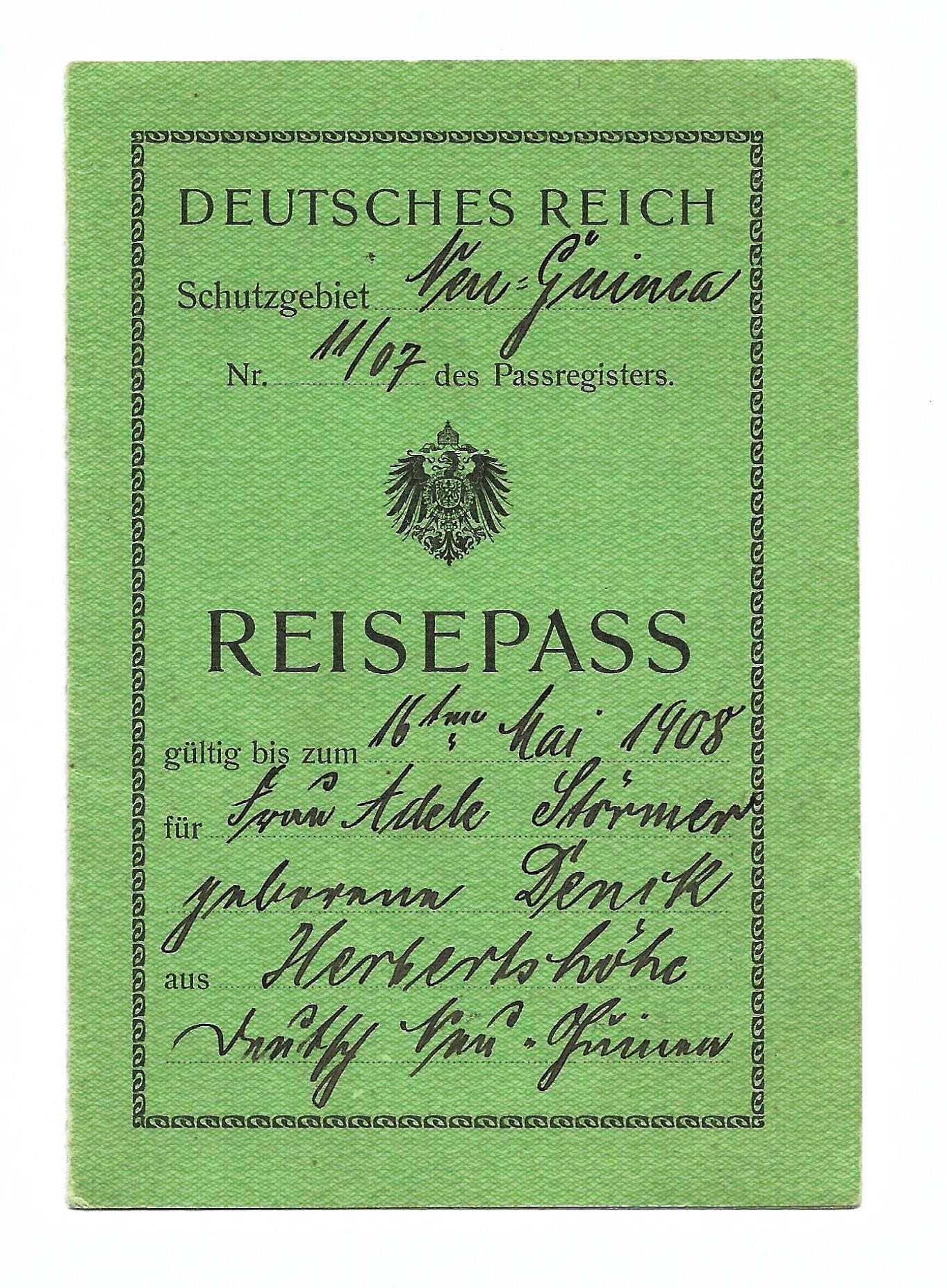
German New Guinea
Otto von Bismarck did not want colonies. The Iron Chancellor had spent years brushing off the colonial enthusiasts who came to his office with maps and pitches about Germany's rightful place under distant suns, and in 1888 he interrupted one such presentation by a man named Eugen Wolf with a famously curt dismissal. Yet it was Bismarck himself who, four years earlier, had signed the papers that made the northeastern quarter of New Guinea a German protectorate. He had not been converted. He had simply decided that if Germans were going to trade copra from Hamburg firms in the South Seas anyway, the imperial flag might as well follow the ledger. On 3 November 1884, that flag rose over Kaiser-Wilhelmsland, and a Pacific empire began that none of its architects particularly believed in.
A Reluctant Empire
The territory that became German New Guinea was not one place but a gathering of them, assembled piecemeal over twenty-two years. Kaiser-Wilhelmsland came first in 1884, the mainland chunk east of the Dutch line. In 1885, the Bismarck Archipelago and the North Solomon Islands were added, with New Britain renamed Neupommern and New Ireland rechristened Neumecklenburg, as though Pacific islands could be reshaped by the naming conventions of Prussian provinces. In 1899, Germany bought the Carolines, Palau, and the Marianas from a weakened Spain for 25 million pesetas, picking over the corpse of another dying empire. The Marshall Islands and Nauru, already under the German flag, were folded in by 1906. All told, the territory covered 249,500 square kilometers of ocean and archipelago, and every bit of it was administered from the harbor on New Britain that would eventually be called Rabaul.
The Business of Taking
The protectorate existed to extract. Plantations producing copra, the dried coconut flesh that Europe rendered into soap and margarine, were the engine of the colonial economy, and plantations demanded labor. When voluntary recruitment failed, the colonial government manufactured compulsion. From 1899 onward, it sent military expeditions to extend direct control over territory after territory, then imposed laws requiring four weeks of labor per person per year and a poll tax payable only in cash that the villagers had no way to earn except by working on German estates. The government tried, with limited success, to recruit workers from China, Japan, and Micronesia. A few hundred came. The local population was left to shoulder the rest. This was the blackbirding and indenture system the Pacific came to know - dressed up in bureaucratic language about tax obligations and labor quotas, but coercive at its core. In Pohnpei in 1910, the Sokehs people rose against the forced labor regime. Germany answered with four warships and 745 troops. By February 1911 the Sokehs leader had surrendered, and the rebellion's leaders were executed.
Missions and Maps
Alongside the traders and administrators came the missionaries. The Rhenish Mission, a Lutheran body under Friedrich Fabri, was assigned the task of converting Kaiser-Wilhelmsland, and its representatives met with fever, violence, and polite indifference from people who had their own cosmologies and no particular hunger for a German one. The Catholic missions sent from Germany fared somewhat better, partly because they were better resourced and partly because they leaned on continuity with local traditions rather than rupture. Meanwhile, inland, the colony remained largely unmapped. When war came in 1914, a young German officer named Hermann Detzner was in the highlands on a surveying expedition. Cut off from his compatriots, he and some twenty local policemen simply vanished into the interior and stayed there for the entire First World War. He emerged in 1919 with a book he titled Four Years Among Cannibals, full of exploratory claims that German missionaries promptly disputed. In 1932, Detzner quietly recanted most of them.
Six Dead at Bita Paka
The colony fell fast. On 11 September 1914, the Australian Naval and Military Expeditionary Force attacked a low-power wireless station at Bita Paka, near Rabaul, on what was then Neu Pommern. The Australians lost six dead and four wounded - the first Australian military casualties of the First World War. The defenders lost one German officer and thirty local policemen killed. Ten days later, on 21 September, the German forces surrendered the colony. The numbers tell a story the triumphal narratives do not. Those thirty dead policemen were Tolai and other Melanesian men, conscripted or recruited into German service, who died defending an empire that had coerced their labor and taxed their villages. The first blood spilled in Germany's Pacific empire was their blood, and when the flag came down, the Treaty of Versailles made no mention of what they had lost.
After the Flag Came Down
Versailles stripped Germany of every colony in 1919, and what had been one territory became several mandates. The League of Nations handed Kaiser-Wilhelmsland and the Bismarck Archipelago to Australia, which administered them as the Territory of New Guinea until the post-war merger that eventually became Papua New Guinea in 1975. The islands north of the equator went to Japan as the South Seas Mandate, and after 1945 passed to American administration as the Trust Territory of the Pacific Islands. Out of that trusteeship came the Federated States of Micronesia, Palau, the Marshall Islands, and the Commonwealth of the Northern Mariana Islands. The only German legacy you can still read on the map is in the archives and the Unserdeutsch language, a German-based creole that was spoken by the children of the Catholic mission at Rabaul and is now down to a handful of elderly speakers. Thirty years of empire, and what remained were scars on land and language that outlasted the empire itself.
From the Air
The former capital at Rabaul sits at 4.20 degrees south, 152.17 degrees east, on Simpson Harbour on New Britain's Gazelle Peninsula. The caldera is unmistakable from altitude - a nearly enclosed bay ringed by volcanic cones, with Tavurvur's dark cinder slope on the eastern rim. The territory's reach extended north across the equator to the Carolines and Marianas, with Palau at roughly 7 degrees north, 134 degrees east. Nearest airport is Tokua (ICAO: AYTK, code RAB), about 50 km southeast of the original town. Weather runs tropical and humid year-round with reliable trade winds; ash plumes from Tavurvur can close the airport on short notice.