Geronimo Surrender Site
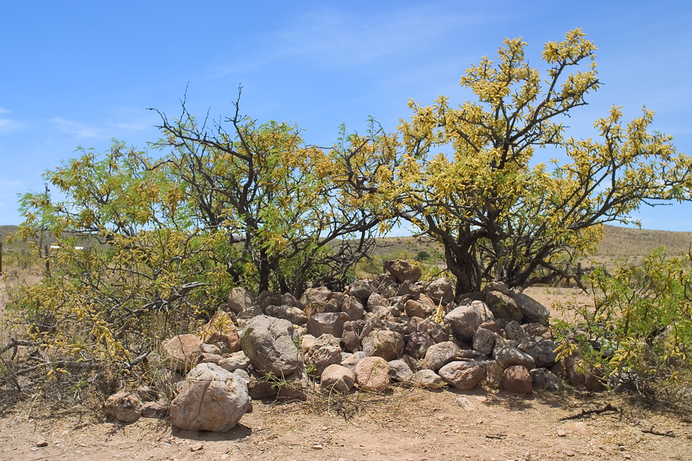
Inside the cairn of stones sits a bottle. Lieutenant Henry Lawton placed it there on September 4, 1886, containing the names of every officer who witnessed what happened on this remote Arizona bluff. The cairn itself, once ten feet across and six feet high, has been picked apart over the years by treasure hunters and curiosity seekers. But the bottle may still be there, a time capsule from the moment when Geronimo finally laid down his weapons and the Apache Wars came to an end.
The Long Pursuit
Geronimo had escaped before. In 1877, he surrendered at San Carlos Reservation, only to flee into Mexico's Sierra Madre when conditions became intolerable. In 1881, after the Cibecue Creek Massacre sparked fears of reprisal, he broke out again. General George Crook tracked him down in 1884 and brought him back. By May 1885, Geronimo was gone once more, leading 140 men, women, and children into the Mexican mountains. For over a year, a small band of roughly 35 Chiricahua Apaches evaded capture while five thousand U.S. soldiers and three thousand Mexican troops scoured two nations trying to find them.
The Man Who Would Only Surrender to Miles
When Lieutenant Charles Gatewood finally caught up with Geronimo on August 24, 1886, he delivered devastating news: all the Chiricahua were being removed from Arizona, relocated to reservations in Florida. The families Geronimo had been fighting to protect were already gone. Deflated, the legendary warrior agreed to surrender, but only to General Nelson A. Miles himself. The U.S. soldiers began escorting the Apache north, arriving at Skeleton Canyon on August 28. Miles arrived six days later. On September 3 and 4, the two men met on a small bluff overlooking the canyon, with sweeping views of the San Bernardino and San Simon Valleys stretching to the east and west.
The View That Sealed the Peace
For years, the National Forest Service believed the surrender took place on the canyon floor, based on oral testimony. But the physical evidence points to this windswept bluff. Geronimo favored high ground with broad sightlines for negotiations, places where ambush was impossible and escape routes visible. The canyon floor could never have accommodated the crowd of officers, soldiers, and Apache witnesses who gathered for the signing. The cairn of stones, placed by Lawton immediately after the agreement, marks the spot. Apache Wars scholars Jay Van Orden, Bill Hoy, and Larry Ludwig all agree: the surrender happened here, on this bluff, with all of southeastern Arizona spread out below.
The End of Forty Years
The treaty signed at this site is considered the most significant agreement between the U.S. Government and Native Americans in Arizona history. It ended four decades of conflict that began in 1846 when American forces first entered Apache territory. Geronimo spent the rest of his life as a prisoner of war, first in Florida, then Alabama, and finally Fort Sill, Oklahoma, where he died in 1909. He never returned to Arizona. But the stones remain, weathered and scattered, on the bluff where a warrior who had outwitted two armies finally accepted that his people's world had changed forever.
From the Air
Located at 31.60N, 109.07W in Skeleton Canyon, southeastern Arizona. The site sits on a small bluff in the Peloncillo Mountains, visible from the air as open terrain above the canyon. Nearby airports include Douglas Municipal (KDUG, 35nm southwest) and Lordsburg Municipal (KLSB, 50nm northeast). Best viewed at 3,000-5,000 AGL. The San Bernardino Valley stretches east, the San Simon Valley west. Terrain rises to 6,000+ feet in surrounding mountains; maintain situational awareness.