Gigantes Islands
The name promises something colossal, and the Gigantes Islands deliver -- just not in the way a Spanish cartographer might have intended. Islas de Gigantes, the Giants' Islands, is a chain of roughly ten islands rising from the Visayan Sea about 18 kilometers off the coast of Panay. No giants live here. What does live here are 14,332 people, by the 2020 census, spread across Gigantes Norte and Gigantes Sur and the scatter of smaller islets between them. They share these islands with 73 caves, a saltwater lagoon enclosed by sheer cliffs, a Spanish-era lighthouse, and a local belief in engkantos -- spirits that inhabit the landscape. The giants, it turns out, are metaphorical.
Two Islands, One Channel
Gigantes Norte and Gigantes Sur are separated by a narrow channel barely half a mile wide. Norte peaks at 213 meters; Sur edges higher at 232 meters. Around them orbit a constellation of smaller islets -- Bulubadiang, Gigantillo, and Gigantuna off the southeastern flank of Norte, and Antonia (also called Cabugao Gamay), Bantigui, Cabugao Daku, Tanguingui, and Turnina trailing south of Sur. Balbagon Island lies 6 kilometers to the west. The geography is limestone and coral, pocked with caves and shaped by water into the kind of formations that invite legends. Locals attribute the islands' peculiarities to engkantos, spiritual beings from Philippine folklore who are said to inhabit places of unusual natural beauty.
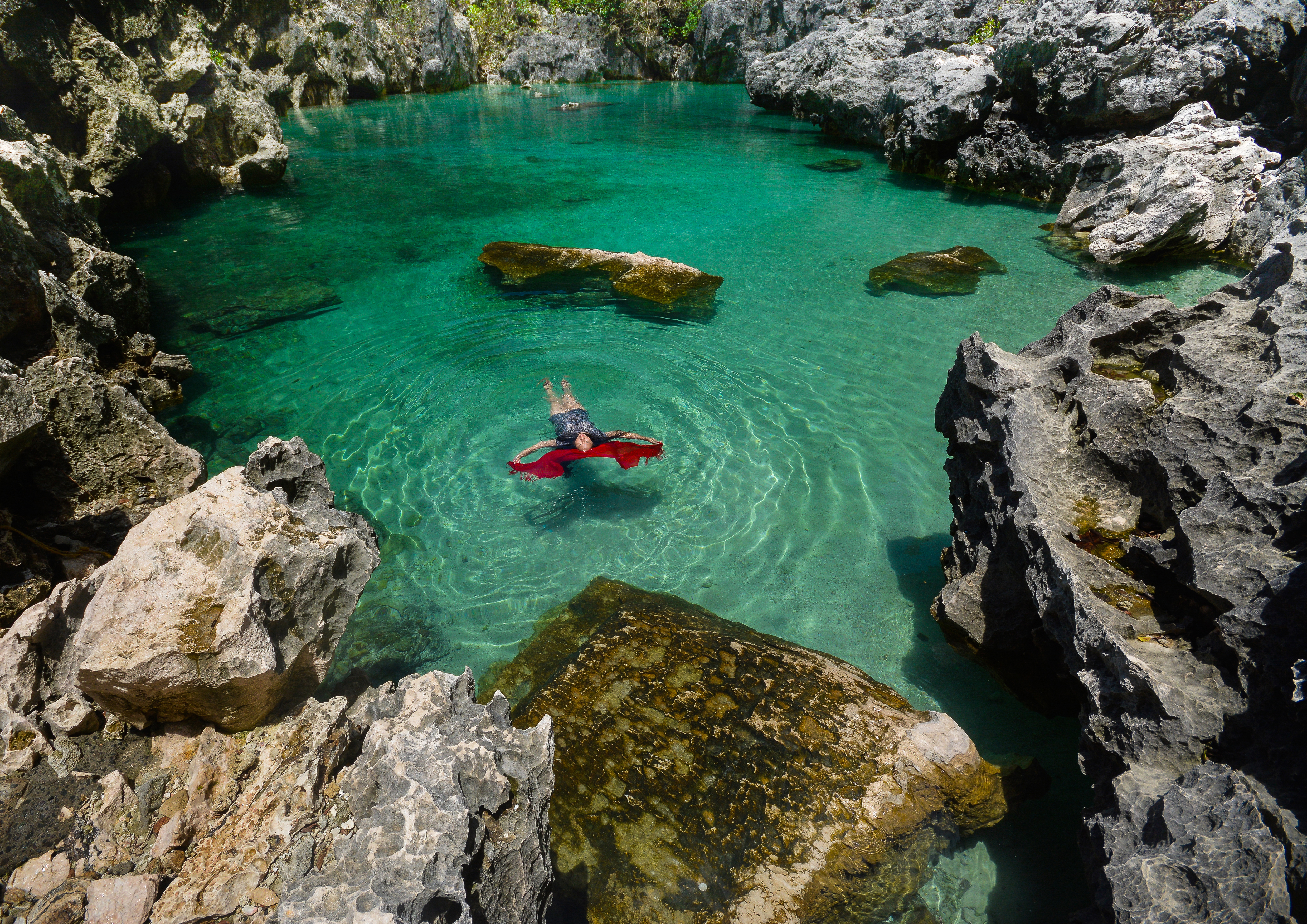
The Lagoon They Call a Tank
Tangke -- the word means "tank" in the local language -- is a saltwater lagoon on Gigantes Sur, completely enclosed by towering limestone cliffs. To reach it, visitors scale the rock walls or swim through a narrow gap at the base. The water inside is clear and still, a pocket of sea trapped by geology. Local legend holds that every June 24, the feast of Saint John the Baptist, the waters of Tangke rise miraculously. Whether the tides or the saint deserve credit, the lagoon remains one of the most striking natural features in the Visayas -- a hidden pool that feels designed to be discovered.
Lighthouses Old and New
A lighthouse was established on Gigantes Norte in 1895 as part of Spain's ambitious program to illuminate the Philippine coastline. The original station featured a white 38-foot tower with a keeper's house, its focal point 77 feet above sea level, flashing once every ten seconds. The brick keeper's house is all that remains of the Spanish structure -- its masonry walls painted white, its corrugated iron roof finished in red. In 2008, Typhoon Frank destroyed the tower, and Japan donated a replacement: a modern, solar-powered, iron lighthouse that now does the work the Spanish beacon once did. The old keeper's quarters stand beside it in partial ruin, arched openings facing the sea, a monument to the era when lighthouse keeping required someone to live at the edge of the world.
After Yolanda
On November 8, 2013, Typhoon Haiyan -- called Yolanda in the Philippines -- tore across the Gigantes group along with the rest of Panay. Unofficial reports estimated that more than 90 percent of the houses on the islands were destroyed. The typhoon ripped the roof from Lantangan Elementary School on Gigantes Sur, a school whose student population of 1,144 exceeded that of mainland schools in the municipality. As of June 2014, the school's roof still had not been repaired. Relief came from a patchwork of organizations: the Bureau of Fisheries and Aquatic Resources, the Department of Social Welfare and Development, Save the Children, the ABS-CBN Foundation, and Loma Linda University Health among them. Save the Children donated more than a thousand bags of school supplies to island students. The community rebuilt, as island communities do -- not because recovery was easy, but because the alternative was leaving, and these islands, for all their vulnerability, are home.
Scallops and Sand Bars
The Gigantes group has become an emerging destination in Western Visayas, known for its white-sand beaches, the Bantigue Sand Bar, and the dramatic Cabugao Gamay Island. Antonia Beach on the southeastern tip of Gigantes Sur gained a reputation for selling scallops at one peso apiece -- a price that turned a simple beach stop into a local legend of its own. Boats from Bancal Port in Carles make the hour-long crossing daily, while ferries from Estancia offer a longer but equally scenic route. The journey itself is part of the experience: an hour or more of open water, watching Panay shrink behind you before the limestone silhouettes of the Gigantes group resolve on the horizon.
From the Air
Located at 11.60°N, 123.34°E in the Visayan Sea, approximately 18 km north of Panay Island. The twin islands of Gigantes Norte (213 m) and Gigantes Sur (232 m) are separated by a narrow channel and surrounded by smaller islets. The lighthouse on Gigantes Norte is a visual reference point. Nearest significant airport is Iloilo International Airport (RPVI), approximately 100 km to the south. Best viewed at 3,000-5,000 ft to appreciate the island chain layout and the surrounding islets.