Gitgit: Where the Clove Road Ends in Mist
The path to Gitgit runs through clove trees. Their scent hits you before the sound of water does - warm, sharp, faintly medicinal - drifting through a canopy that also shelters coffee bushes, cacao plants, and the tall nutmeg trees that made these Indonesian islands objects of European obsession for centuries. Then the trail drops, the canopy opens, and the waterfall appears: a single column of white water falling roughly 35 meters into a pool of deep green, surrounded by ferns and moss-covered boulders. Gitgit has been a tourist attraction since 1939, when the Dutch colonial government first opened the trail to visitors. Nearly nine decades later, the falls remain northern Bali's most famous natural spectacle - not because they are the most powerful or the most remote, but because the walk to reach them is itself a journey through the island's layered landscape of agriculture, forest, and sacred water.
The Spice Trail Down
Getting to Gitgit Waterfall requires a fifteen-minute trek from the parking area along a path that functions as an informal botanical tour of Bali's highland agriculture. The trail winds through clove plantations where the trees grow tall and slender, their aromatic buds harvested by hand when they flush pink before flowering. Interspersed among the cloves are coffee plants - mostly robusta, the hardy variety that thrives at these mid-range elevations around 300 meters above sea level. Cacao trees crowd the understory, and vanilla vines climb whatever they can reach. This is not wilderness. It is a working landscape cultivated over centuries, and the waterfall at its terminus has always been part of the territory's appeal rather than separate from it. The Sukasada District, where Gitgit Village sits, lies about 10 kilometers south of Singaraja, the old colonial capital of Bali, along a road that climbs steadily into the central mountains.
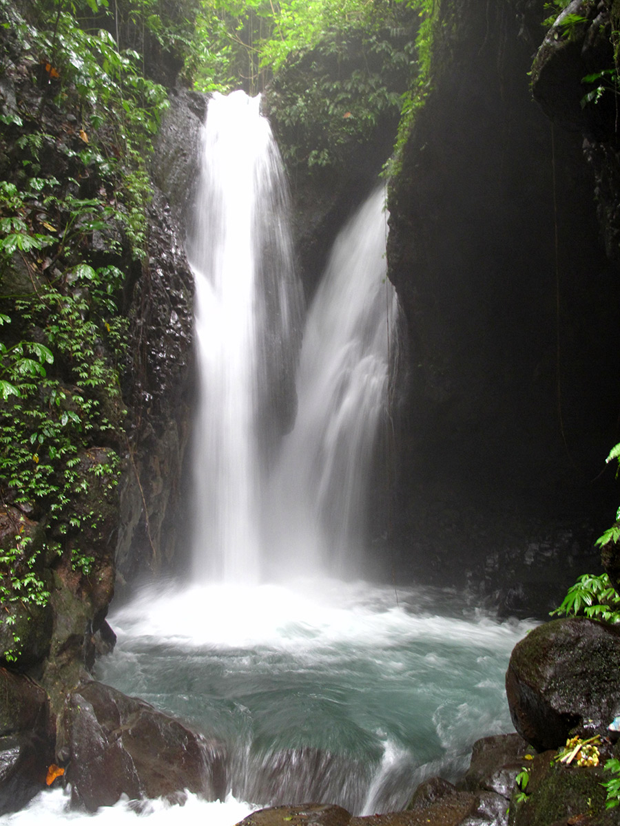
Three Cascades, One River
Gitgit is not a single waterfall but a series of cascades along the same river system in the Tukad Buleleng basin. The main fall - the one most visitors photograph - drops approximately 35 meters in a single unbroken column, making it among the tallest on the island. But continue upstream and you reach the Twin Falls, a pair of parallel cascades where the river splits around a rock outcrop before reuniting below. Further still, a third cascade called Colek Pamor offers a more secluded experience, its pool deeper and its setting wilder. The water is cold by Balinese standards, fed by springs high in the central mountains where Bali's volcanic peaks trap moisture from the Indian Ocean. Natural swimming pools form at the base of each cascade, their edges smoothed by centuries of erosion. The river that feeds Gitgit was historically important for irrigation as well - the Dutch colonial administration developed a dam system here, diverting water to rice terraces on the coastal plain below.
A Colonial Tourist Attraction
Gitgit's history as a managed attraction predates Indonesian independence. In 1939, a Dutch official named Hooykaas, who chaired the Liefrinck-Van der Tuuk Institute at Gedong Kirtya in Singaraja, arranged for the waterfall to be opened to public visitors. Gedong Kirtya was - and remains - a library of lontar palm-leaf manuscripts, one of the most important repositories of Balinese and Old Javanese texts in existence. That the same scholarly institution that preserved ancient literature also promoted waterfall tourism tells you something about the Dutch approach to Bali: the island was simultaneously a subject of serious academic study and an exotic destination marketed to European travelers. Singaraja, just 10 kilometers to the north, served as the colonial capital of Bali and the Lesser Sunda Islands, its harbor the main point of entry to the island before Ngurah Rai airport opened in the south. Gitgit was one of the first natural attractions that colonial visitors encountered after disembarking.
Northern Bali's Other Face
Most tourists experience Bali from the south - the beaches of Kuta, the rice terraces of Ubud, the temple at Tanah Lot. Northern Bali is a different island. The climate is drier, the coastline steeper, the tourism infrastructure thinner. Singaraja, once the island's most important city, now feels like a provincial town overshadowed by the resort developments of the south coast. The road from Denpasar to Gitgit crosses the central mountain range, climbing past Lake Bratan and the cliffside temple of Ulun Danu before descending through the plantation belt where Gitgit sits. At 83 kilometers from Ngurah Rai International Airport, the waterfall is close enough for a day trip but far enough to filter out the casual beach crowd. The visitors who make the drive tend to find an atmosphere markedly different from southern Bali's resort bustle - quieter, greener, cooler in temperature and temperament. Munduk, a hillside village 26 kilometers to the west, has become a destination in its own right for travelers seeking Bali's highland character without the crowds.
From the Air
Located at 8.19S, 115.13E in northern Bali's central highlands at approximately 300 meters elevation. The waterfall is nestled in a river gorge within the Tukad Buleleng basin, not directly visible from high altitude but the surrounding lush green canopy and river system are identifiable. Singaraja, the largest city on Bali's north coast, lies 10km to the north. The nearest major airport is Ngurah Rai International (WADD/DPS) approximately 83km to the south. From the air, approach over Bali's central volcanic spine - Mount Agung (3,142m) to the east, Mount Batur (1,717m) and Lake Batur nearby, and Mount Batukaru (2,276m) to the west. The green plantation belt along the northern slopes is visible as a band of darker vegetation between the volcanic peaks and the drier coastal plain. Northern Bali receives less rainfall than the south; visibility is generally excellent in the dry season (April-October). The Bali Sea stretches north toward Java.