Glacier National Park: Racing to See the Ice Before It Melts
When Glacier National Park was established in 1910, it contained approximately 150 glaciers. Today, 26 remain, and they're shrinking. Grinnell Glacier, once a dramatic ice mass visible from Going-to-the-Sun Road, has lost over 75% of its area since the 1850s. Climate models suggest the park could be glacier-free by 2030 or 2050, depending on emissions. The irony is bitter: the ice that gives the park its name is melting because of the carbon emissions of the visitors who come to see it. Yet the landscape remains spectacular - the carved valleys, the alpine lakes, the mountain goats on impossible ledges. The glaciers shaped this place. Their absence will change what it means.
The Glaciers
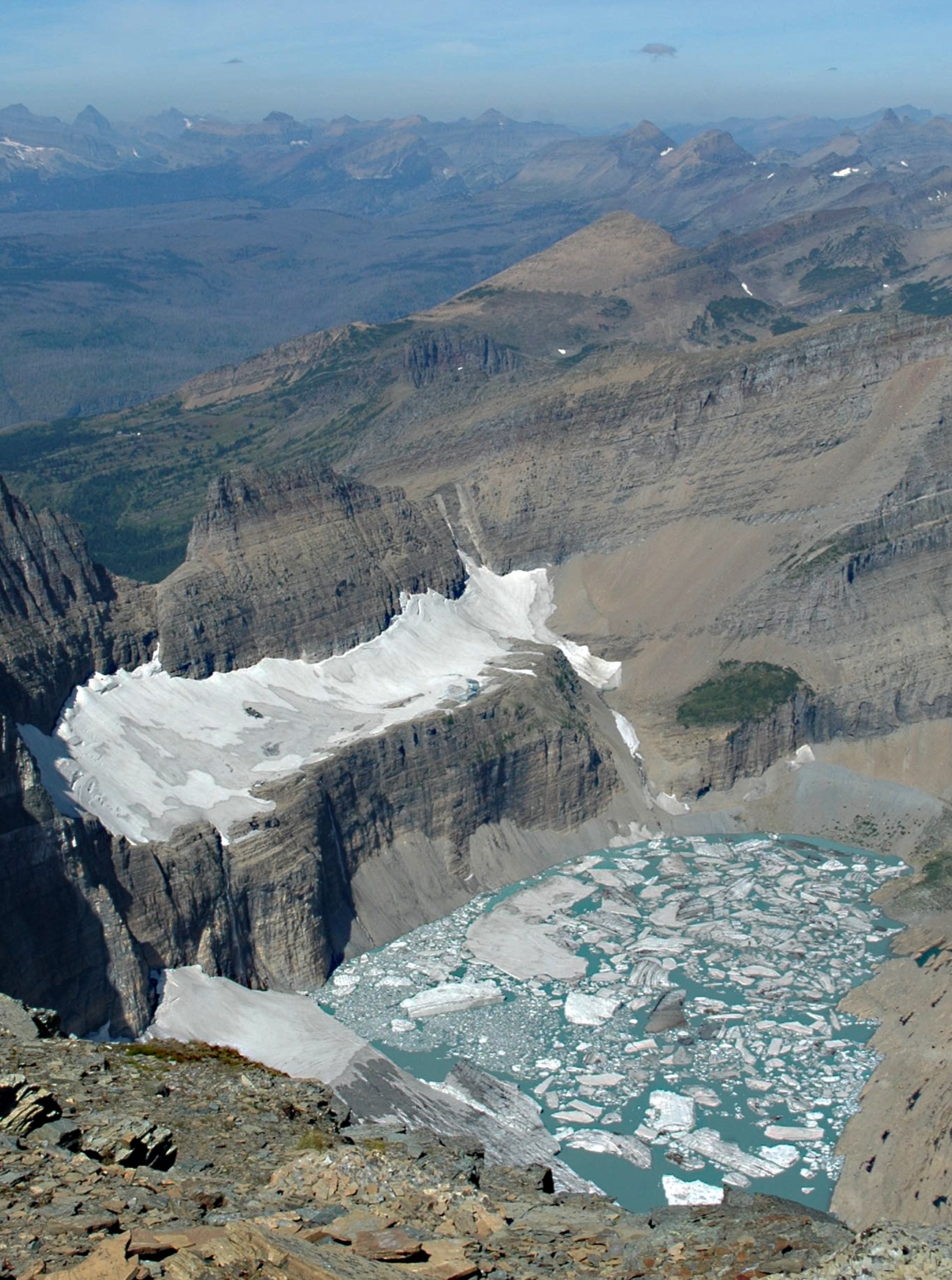
The park's glaciers are relics of the Little Ice Age, which ended around 1850. Since then, they've retreated continuously, with acceleration in recent decades. Grinnell Glacier, the most accessible and most studied, covered 710 acres in 1850; it now covers roughly 150 acres, split into multiple fragments. Jackson Glacier, visible from the road, has retreated dramatically. Sperry Glacier persists in the shadows. The USGS maintains monitoring stations tracking the loss; the data is unambiguous. The glaciers are dying. Some visitors come specifically to see them while they last, creating traffic jams on roads that weren't built for such crowds.
The Road
Going-to-the-Sun Road is an engineering marvel that crosses the park, climbing 3,000 feet to Logan Pass at the Continental Divide. Built between 1921 and 1932, the road traverses cliff faces, tunnels through rock, and provides access to alpine terrain that would otherwise require serious hiking. The narrow road cannot accommodate modern RVs and large vehicles; restrictions apply. Snow closes it from October through June most years. In summer, the road is crowded, the parking lots full, the experience shaped by the infrastructure built for 1930s traffic volumes. Yet the views remain: the Garden Wall, Heaven's Peak, the turquoise waters of Saint Mary Lake.
The Wildlife
Glacier hosts the most intact ecosystem in the lower 48 states. Grizzly bears roam the backcountry; black bears are common throughout. Mountain goats navigate the cliffs. Wolves returned in the 1980s and now maintain stable packs. Wolverines, lynx, and countless smaller species persist in habitats protected since 1910. The wildlife exists because the landscape does - the wildness of steep terrain that resisted development, now formally protected. Hikers carry bear spray and make noise on trails; the encounters remain real. The park offers the experience of genuinely wild land in a country where such land is increasingly rare.
The Hikers
Glacier contains over 700 miles of hiking trails ranging from gentle lakeside strolls to demanding alpine crossings. The Highline Trail traverses the Garden Wall with views that justify any crowd. The Grinnell Glacier Trail ends at the shrinking ice. The Ptarmigan Tunnel punches through a ridge at 7,000 feet. The backcountry is accessed by permit; reservations fill months ahead. The front-country trails are crowded in summer, especially those accessible from Going-to-the-Sun Road. The solution is simple: start early, hike longer trails, accept that everyone else had the same idea. The landscape rewards effort with solitude.
Visiting Glacier National Park
Glacier National Park is located in northwestern Montana, along the Canadian border. The west entrance at Apgar is the most accessible, near Kalispell. The east entrance at Saint Mary provides access to the other side of the park. Going-to-the-Sun Road connects both sides, typically open late June through October; vehicle reservations are required during peak season. Many Glacier, on the park's east side, offers excellent hiking access. Lodging within the park is limited and books far in advance; gateway towns offer more options. The hiking season is short - July through September for most alpine trails. The experience rewards planning: the park is crowded in summer, spectacular always, and changing in ways that make each visit potentially different from the next.
From the Air
Located at 48.76°N, 113.78°W in northwestern Montana, along the Canadian border. From altitude, Glacier National Park appears as a mass of peaks and valleys cut by glaciation - U-shaped valleys, cirque lakes, horn peaks, and arêtes visible in the geology. The remaining glaciers appear as white patches on north-facing slopes, smaller each year. Going-to-the-Sun Road is visible as a thread crossing the park, climbing to Logan Pass. Lake McDonald dominates the west side; Saint Mary Lake fills the east. The Canadian border crosses the peaks to the north, where Waterton Lakes National Park continues the protected area. What appears from altitude as dramatic mountain wilderness is a park racing against time - its namesake glaciers melting, its landscape the record of ice that's disappearing.