Glacier National Park
The mountains here are old beyond imagining. The layered rock beneath your feet was seafloor sediment 1.6 billion years ago, long before complex life existed on Earth. Glaciers carved these peaks into their present knife-edge form during the last ice age, scooping out U-shaped valleys and leaving behind hundreds of pristine lakes that mirror the sky. This is Glacier National Park, where the Rocky Mountains reach their most dramatic expression - a million acres of wilderness straddling the Continental Divide in northern Montana. The Blackfeet people have called this region home for centuries, and standing at Logan Pass with peaks stretching to every horizon, you understand why this landscape commands such reverence.
The Road Through the Sky
Going-to-the-Sun Road is engineering audacity carved into living rock. Completed in 1932 after eleven years of construction, this 50-mile route climbs from the cedar forests along Lake McDonald to the alpine tundra at Logan Pass, then descends the continental divide's east face to the prairies beyond. The road hugs cliffsides where workers once dangled from ropes to blast passages through sheer walls. At points, the pavement clings to a narrow shelf with nothing but air between you and the valley floor far below.
The views are relentless. Glacier-fed waterfalls cascade directly onto the road after snowmelt. Mountain goats pick their way along precipices that would make a climber hesitate. The Garden Wall, a knife-edge ridge of ancient argillite, glows red and green in the afternoon light. Vintage red buses called 'Jammers' - named for the gear-jamming required on the steep grades - have carried visitors along this route since the 1930s, their canvas tops rolled back to reveal the enormity of the sky.
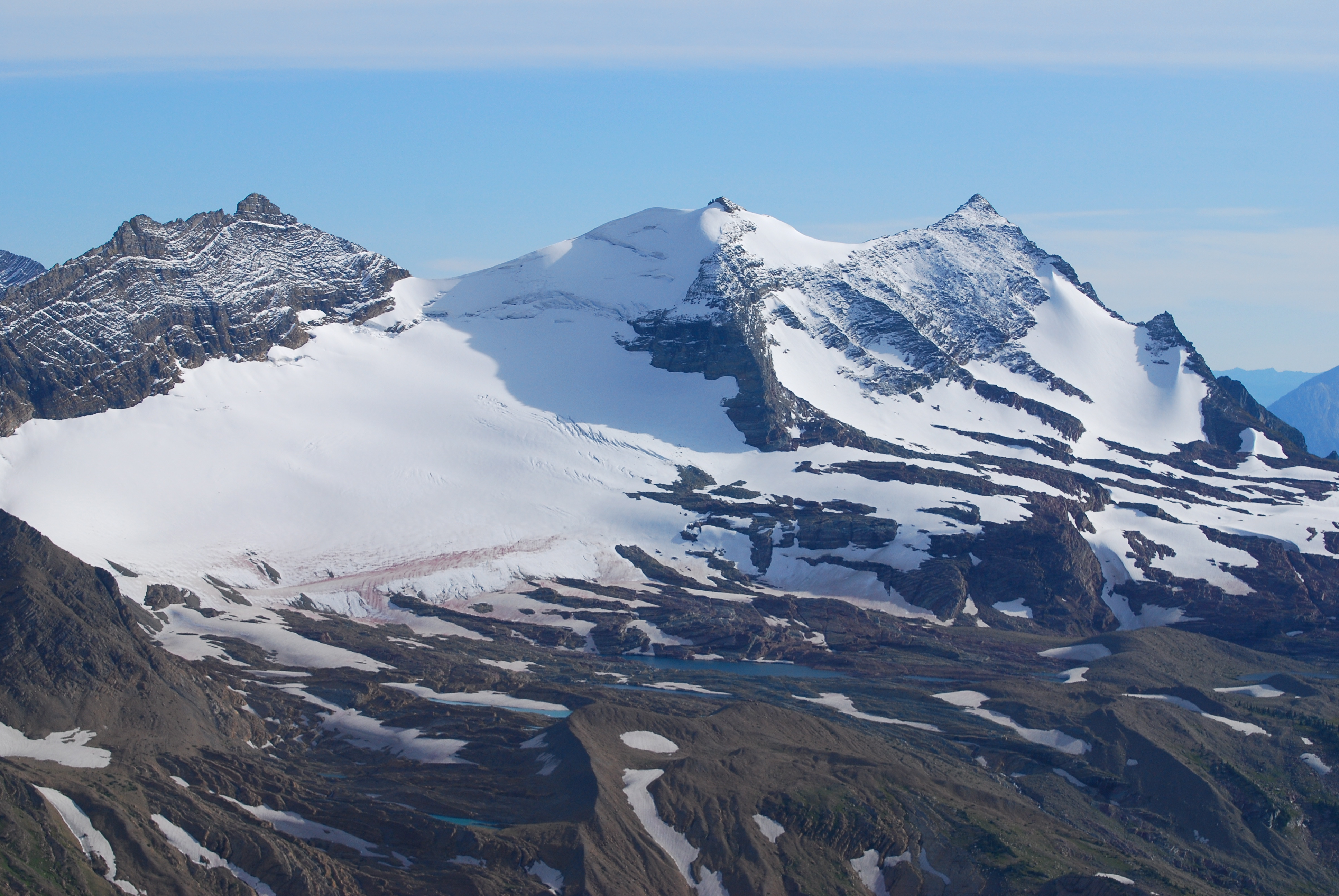
Ice on Borrowed Time
The glaciers that gave this park its name are retreating. Climate scientists have documented their shrinking over decades, a transformation visible within a single human lifetime. Research from the USGS Northern Rocky Mountain Science Center projects continued decline as temperatures rise.
But the ice endures for now. Grinnell Glacier still clings to the flanks of Mount Gould, its meltwater feeding an impossibly turquoise lake. Sperry Glacier hides in a remote cirque accessible only by a strenuous day hike or overnight stay at the historic stone chalet perched on the ridge above. These remnants of the last ice age are windows into deep time, their annual changes written in moraine and meltwater. The landscape they reveal is stark and beautiful - raw rock gardens where life is slowly returning after millennia beneath the ice.
Wild Kingdom
Glacier harbors ecosystems almost unchanged from what Lewis and Clark would have encountered. Grizzly bears fish the streams in late summer and forage for huckleberries on the slopes - this remains one of the largest grizzly habitats in the lower 48 states. The park also protects endangered species including the Canadian lynx and bull trout. Twenty-three species of fish inhabit park waters.
Mountain goats are the park's most visible residents, their white coats bright against dark rock as they navigate impossible terrain near Logan Pass. Bighorn sheep congregate at mineral licks. In the crystalline streams, native trout still spawn in waters their ancestors knew. Signs at every trailhead remind visitors they're entering grizzly country, and the knowledge adds an electric awareness to every footstep through the backcountry.
Peace Across Borders
In 1932, Glacier and Canada's Waterton Lakes National Park became the world's first International Peace Park - a gesture of friendship between nations that share this magnificent landscape. The parks were designated UNESCO Biosphere Reserves in 1976 and World Heritage Sites in 1995. The boundary between countries bisects the wilderness, but the mountains and wildlife recognize no borders.
The Peace Park designation was visionary for its time, recognizing that ecosystems don't end at surveyor's lines. Today, the parks cooperate on wildlife management, fire control, and scientific research. Chief Mountain, sacred to the Blackfeet people, rises near the boundary crossing, visible from both nations. The international border here feels less like a division than a seam - two pieces of the same spectacular whole.
Into the Backcountry
Beyond the highway corridor lies wilderness that few visitors ever see. Over 700 miles of trails penetrate valleys where the only sounds are wind and water. The Continental Divide Trail threads through the park's heart, one of the most challenging and beautiful sections of the 3,100-mile Mexico-to-Canada route. Backcountry campgrounds perch beside alpine lakes and beneath sheer headwalls.
The commitment required to reach these places is part of their magic. A dawn start from Many Glacier leads through flower-strewn meadows to Grinnell Glacier by afternoon. The Highline Trail traces the Garden Wall for nearly twelve miles of exposed grandeur. Granite Park Chalet offers rustic refuge for those willing to earn it. In these remote corners, the park reveals its truest character - not a scenic drive, but a wild sanctuary where humans are visitors and the mountains keep their own counsel.
From the Air
Located at 48.68N, 113.79W on Montana's northern border with Canada. The park is unmistakable from altitude - look for the distinctive knife-edge peaks of the Lewis and Livingston Ranges with numerous glacial cirques and tarns. Going-to-the-Sun Road is visible as a thin line carved into the mountainside near Logan Pass (6,646 ft). Lake McDonald on the west side and St. Mary Lake on the east are the largest bodies of water. The Continental Divide runs north-south through the park. Waterton Lakes National Park continues the landscape northward into Canada. Nearest airports: Glacier Park International (KGPI/FCA) in Kalispell, 25 miles southwest; Great Falls International (KGTF) 150 miles southeast. Summer weather typically clear with afternoon thunderstorms possible at higher elevations. Snow possible any month at alpine elevations.