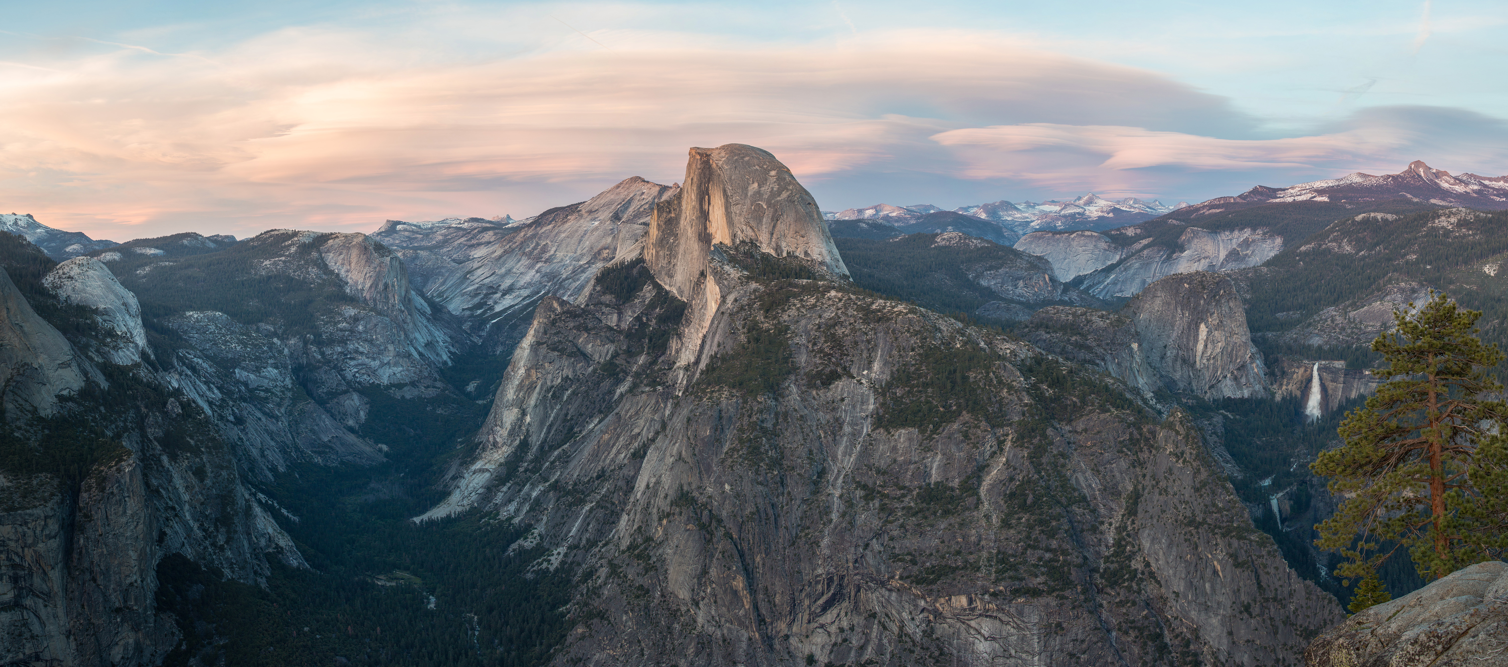
Glacier Point
Stand at the railing on Glacier Point and you are standing on evidence of a world that vanished ten thousand years ago. The boulders scattered across this promontory did not come from here. Geologists have traced them to their sources - Half Dome quartz monzonite from Little Yosemite Valley, rose-colored granite that could only have originated at Mount Clark, eight miles to the southeast. Glaciers carried these rocks here, grinding their way through the Sierra Nevada and depositing the debris on this ledge like calling cards left by a departing guest. The ice is long gone. What it left behind is one of the most commanding viewpoints in the American West: a bare granite shelf at 7,214 feet that looks out over Yosemite Falls, Half Dome, Vernal Fall, Nevada Fall, and Clouds Rest in a single panorama that compresses millions of years of geologic violence into something the human eye can hold.
Stones from Distant Mountains
The geology of Glacier Point tells a story of transportation on a continental scale. Three distinct types of glacially deposited rock litter the promontory and its slopes. The most abundant are rounded boulders and deeply weathered fragments of Half Dome quartz monzonite, the same light-colored granite that forms Half Dome and the heights surrounding Little Yosemite Valley. Rarer but more revealing are boulders of a coarse-grained, siliceous granite - light buff when freshly broken, vivid rose when weathered. Only one formation in the High Sierra matches this rock: Mount Clark, the sharp-profiled peak standing on the east side of the Illilouette Basin. For these boulders to reach Glacier Point, a glacier would have had to flow out of the Illilouette drainage and across the south wall of the valley. The extreme tip of the promontory is bare rock, scoured clean, but the slopes below and the wooded areas above are littered with glacial material - a landscape still wearing the fingerprints of ice.
Four Miles Straight Up
Before there was a road, there was only the trail. The Four Mile Trail, completed in 1872, was Yosemite's first formal route to Glacier Point - a steep, punishing path that climbed 3,200 vertical feet from the valley floor in switchbacks tight enough to make mules reconsider their careers. For a decade, this was the only way up. Then in 1882, the Yosemite Stage and Turnpike Company received permission to build a stage road, offering visitors a longer but less vertical route by horse-drawn carriage. By the early 1900s, the road had been improved for automobiles, and in 1917 the federal government took control of it - the same year the Glacier Point Hotel opened on the overlook. Each improvement in access brought more visitors, and each wave of visitors reinforced the idea that Glacier Point was not just a geologic feature but a destination, a place where the park condensed itself into a single view.
The Nightly Spectacle
Between 1872 and 1968, Glacier Point was the launching pad for the Yosemite Firefall. Staff at the Glacier Point Hotel would build a bonfire of Red Fir bark at the cliff's edge and, at nine o'clock each summer evening, rake the glowing embers over the precipice. The coals fell 3,000 feet, catching updrafts and spreading into a luminous curtain visible from Camp Curry on the valley floor. The tradition drew enormous crowds, but the National Park Service eventually concluded that it had no place in a wilderness preserve. The last Firefall fell on January 25, 1968. The hotel itself burned down the following year. Today, Glacier Point's most famous fire-related spectacle is entirely natural: in mid- to late February, the setting sun sometimes illuminates nearby Horsetail Fall on El Capitan's eastern face, turning the waterfall into what photographers call the "natural firefall" - a coincidence of water, light, and angle that lasts about ten minutes and cannot be scheduled.
The View in Winter
Summer crowds fill the parking lot and line the railings, but Glacier Point in winter belongs to a different category of visitor. Glacier Point Road closes when the snow arrives, usually by November, and does not reopen until June. The only way to reach the overlook during those months is by cross-country ski or snowshoe from the Badger Pass Ski Area - a journey that filters out everyone except those willing to work for the view. The reward is silence, and a panorama that gains an entirely different character under snow. Half Dome wears a white cap. The waterfalls thin to frozen ribbons or disappear entirely. The granite walls of the valley, dark against the snow, look less like scenery and more like the architecture of the planet itself. It is the same view available to summer tourists from behind a guardrail, but earning it on skis in February changes what you see. The valley feels less like a postcard and more like a place where geology is still happening, slowly, under all that ice.
From the Air
Located at 37.7308°N, 119.573°W on the south rim of Yosemite Valley at 7,214 feet elevation. The promontory extends as a prominent bare granite shelf from the south valley wall, easily identifiable from the air. Half Dome rises to the northeast, Yosemite Falls to the northwest. Glacier Point Road is visible as a winding route from the south. Nearest airports: Fresno Yosemite International (KFAT), approximately 65 miles south; Mariposa-Yosemite Airport (MPI), approximately 30 miles west. Best viewed at 3,000-5,000 ft AGL. The Four Mile Trail switchbacks are visible on the cliff face below.