Godin Tepe
Two ceramic jars, each 60 centimeters tall with a capacity of 30 liters, sat in a small room beside a necklace of 200 black and white beads. A small hole had been drilled 10 centimeters above the base of each jar. Chemical analysis revealed what the holes were for: these were vessels for making wine, dating to roughly 3100-2900 BCE. At Godin Tepe, in the Kangavar valley of western Iran, the residents were fermenting grapes and brewing beer five thousand years ago, and the archaeological record preserves not just their drinking habits but the entire arc of a civilization that lasted from 5200 BCE until an earthquake ended it.
The Crossroads of Trade
Godin Tepe rises 30 meters above the plain on the left bank of the Gamas Ab river, a 15-hectare mound in the Luristan region of Kermanshah Province. Its importance was geographic. The Kangavar valley sits along routes that connected Mesopotamia to the Iranian plateau, and Godin served as a trading outpost where goods moved between lowland and highland civilizations. By the Late Chalcolithic period, around 4200 BCE, substantial trading networks had formed here for metals and precious stones. Lapis lazuli, the deep blue stone found naturally only in Badakhshan in northeastern Afghanistan, began appearing at the site in significant quantities. Someone was moving luxury goods across thousands of kilometers, and Godin Tepe was a waystation on that route.
Seals, Tablets, and the Uruk Connection
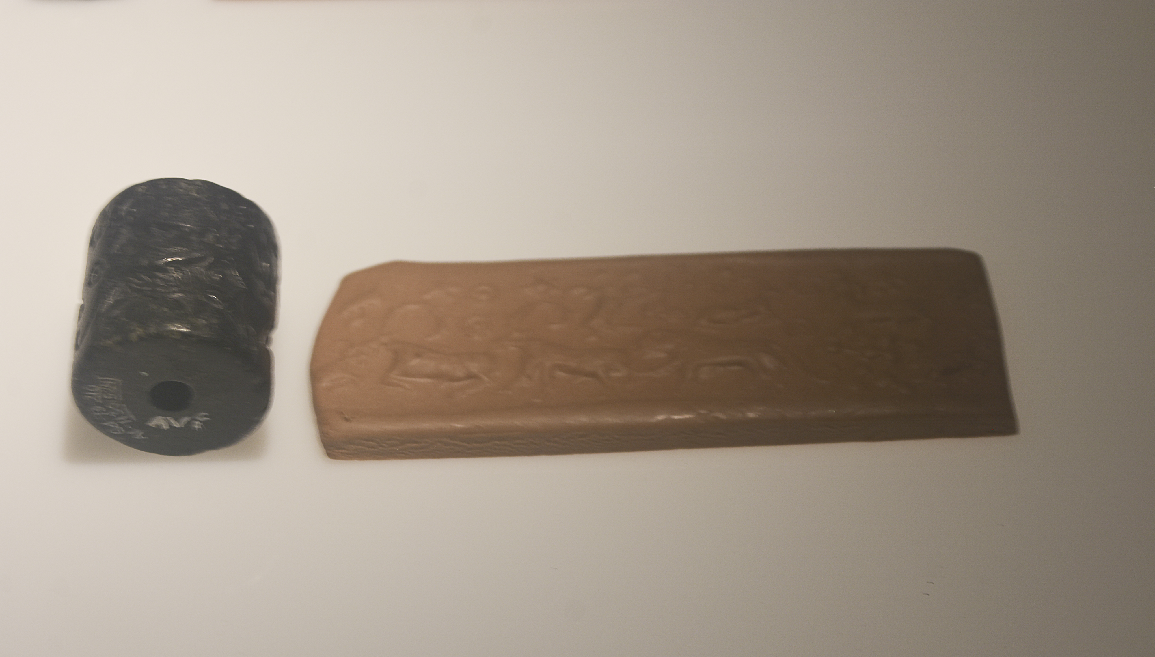
At Level VI, dated roughly 3500-3200 BCE, Godin Tepe reveals its deepest connections to Mesopotamian civilization. Thirty-eight clay tablets of the numerical or impressed type were found, 27 preserved intact. They contained accounts, the ancient equivalent of bookkeeping, identical in type to tablets found at Uruk-period sites across Iran, Syria, and Mesopotamia. Seven were sealed. Thirteen seal impressions and two cylinder seals appeared at the same level, likely produced locally based on the discovery of an uncarved cylinder blank. The pottery shows unmistakable Uruk influence, including the distinctive beveled rim bowls that served as standard-issue rations containers throughout the Uruk commercial sphere. Elamite merchants from Susa may have established trading posts here, turning this mountain site into a branch office of lowland commerce.
Peoples Come and Go
Around 3000 BCE, possibly after a gap in occupation, new people arrived. The pottery shifts abruptly to Transcaucasian styles associated with the Kura-Araxes culture, well known from sites near Lake Urmia to the north. Grey-black burnished surfaces, conical bowls with incised designs sometimes filled with whitish paste, jars with protruding rims: the material culture announces a population from the Caucasus region settling in a valley that had previously looked south toward Mesopotamia. By Level III, spanning roughly 2600 to 1400 BCE, connections swung back toward Susa and the Elamite confederacy. Then around 1400 BCE, an earthquake destroyed the settlement, and Godin Tepe fell silent for over six centuries.
The Iron Age Revival
When people returned around 750 BCE, they built on a different scale. A fortification wall 120 meters by 50 meters and three meters thick went up, complete with arrow slits. Inside, a columned hall measuring 24 by 28 meters was supported by 30 wooden columns arranged in five rows of six. The interior was plastered, with a raised area along the northwest wall. The excavators found no military trappings and interpreted the building as a palace or manor house for a local ruler. The wall gradually fell out of use, suggesting the security threat passed or the ruler's power waned. Much later, in the 15th century, an Islamic shrine appeared at Level I, the last chapter of human occupation on this ancient mound.
Unearthing Seven Millennia
T. Cuyler Young Jr. discovered Godin Tepe in 1961 during a regional survey sponsored by the University Museum of the University of Pennsylvania, and began excavation in 1965 under the auspices of the Royal Ontario Museum. Work continued through 1973 across the site's three zones: the Outer Town, the Upper Citadel, and the Citadel. The northern end of the mound has eroded to a cliff. Locals have removed earth for brick-making and agriculture, and an Islamic cemetery occupies the southeast side of the Outer Town. A modern road cuts through the southern portion. Despite these intrusions, the stratigraphy runs so deep that a related site six kilometers away, Seh Gabi, was excavated simply to access the earliest levels more easily. From its first inhabitants in 5200 BCE to its last in the 15th century, Godin Tepe compressed seven millennia of human endeavor into 30 vertical meters of earth.
From the Air
Godin Tepe is located at approximately 34.52N, 48.07E in the Kangavar valley of Kermanshah Province, western Iran. The site is a prominent mound rising 30 meters above the surrounding agricultural plain along the Gamas Ab river. Nearest airports include Kermanshah (OICC) and Hamadan (OIHH). The Zagros Mountains form the dominant landscape feature. Recommended viewing altitude: 5,000-8,000 feet AGL to see the mound in its valley context.