Golfo Dulce
The name translates as "Sweet Gulf" -- not "Gulf of Dulce," as mistranslations would have it -- and the sweetness is real. Tucked between the Osa Peninsula and mainland Costa Rica at the bottom of Puntarenas Province, Golfo Dulce is one of only four tropical fjords on Earth. Its warm, sheltered waters average nearly 85 degrees Fahrenheit year-round, creating a biological hothouse unlike almost anywhere else in the Pacific. In 2019, oceanographer Sylvia Earle's Mission Blue designated it a Hope Spot, one of the ocean areas deemed critical to planetary health. From the air, the gulf appears as a long, calm bite taken out of Costa Rica's rugged southwestern coastline, the green walls of rainforest plunging straight into turquoise water.
A Fjord in the Tropics
Most fjords belong to the cold latitudes -- Norway, Patagonia, Alaska. Golfo Dulce breaks the pattern. It is considered a tropical fjord because of its deep, enclosed basin and limited water exchange with the open Pacific, characteristics that typically result from glacial carving. Here, tectonic forces did the work instead. The gulf extends northward from the Pacific, then turns west toward the town of Rincon at its innermost point, creating a pocket of warm, nutrient-rich water separated from the open ocean by a shallow sill. That sill restricts circulation, trapping warmth and organic matter. Five to six meters of annual rainfall wash nutrients from the surrounding forests into the gulf, feeding a marine food web of extraordinary density. The seventeen protected reserves around its shores account for just three percent of Costa Rica's land area, yet harbor roughly half the country's known flora and fauna.
The Shark Nursery
Marine biologists Ilena Zanella and Andres Lopez spent years tracking scalloped hammerhead sharks with acoustic tags, documenting a migration pattern that stunned researchers. Adults feed and mate in the pelagic waters around Cocos Island, 550 kilometers offshore. But when females are ready to give birth, they travel to the shallow estuaries and mangroves of northern Golfo Dulce. The warm, nutrient-rich waters provide ideal nursery conditions for pups and juveniles. In May 2018, Costa Rica created a 4,000-hectare no-take zone in these wetlands -- the country's first shark sanctuary. The designation aims to prevent the capture of hammerheads in bottom long-line fishing, where they die as bycatch, their fins sliced off and their bodies discarded. Zanella received a Whitley Award in 2019 for her conservation work with this endangered species.
Where Two Migrations Collide
Humpback whales arrive in Golfo Dulce from two directions. Northern Hemisphere populations migrate south between December and March; Southern Hemisphere populations swim north between July and November. The overlap makes the gulf one of the longest whale-watching seasons anywhere -- roughly nine months of the year. Spotted dolphins, bottlenose dolphins, and orcas also frequent the warm waters. Below the surface, sea turtles -- Pacific green, olive ridley, hawksbill, and Pacific leatherback -- feed on jellyfish and marine plants. Whale sharks drift through. Yellow-bellied sea snakes and saltwater American crocodiles patrol the shallows. The marine census reads like an inventory of the entire eastern Pacific compressed into a single bay.
A Canopy of Wings and Howls
Step off a boat onto any shore of the gulf and the jungle begins immediately. All four of Costa Rica's monkey species live here: the Central American squirrel monkey, Geoffroy's spider monkey, the mantled howler, and the white-headed capuchin. Scarlet macaws flash through the canopy in pairs, their red-and-blue plumage startling against the green. Yellow-billed toucans perch on fruiting trees. On the forest floor, an endemic species tells the story of this place's isolation: the Golfo Dulce poison dart frog, found nowhere else on Earth, its tiny body a warning signal in the leaf litter. Two to three percent of the surrounding flora exists only here, evolved in the particular wet heat where mountains meet the sea.
The Shores and Their Struggles
Four communities ring the gulf, each with a different relationship to the water. Golfito, to the east, runs on palm oil plantations and has a small airport linking it to domestic flights. Zancudo, to the northwest, is one of Costa Rica's least inhabited stretches of coastline, drawing visitors with pristine beaches. The Osa Peninsula, to the west, contains the largest protected land area around the gulf and attracts eco-tourists alongside surfers who ride the famous left break at Matapalo. Pavones, to the south, claims the second-longest point break on Earth. But the gulf faces real threats. Garbage from Golfito and Pavones washes into rivers and out to sea, entangling marine life and leaching chemicals. Palm oil plantations outside protected zones have replaced native jungle, displacing wildlife. The tension between economic survival and ecological preservation plays out daily along these shores -- a contest whose outcome will determine whether the Sweet Gulf stays sweet.
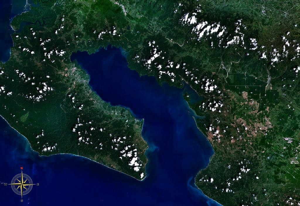
From the Air
Located at 8.58N, 83.27W on Costa Rica's southern Pacific coast. From altitude, Golfo Dulce is clearly visible as a large, enclosed body of water separating the Osa Peninsula from the mainland. The gulf stretches roughly 50 km long and 10-15 km wide, with dense rainforest lining both shores. Nearest airports: Golfito (MRGF) on the eastern shore and Palmar Sur (MRPM) to the north. The Osa Peninsula's jagged coastline and the wide mouth of the gulf opening to the Pacific are prominent landmarks. Best viewed at 5,000-10,000 ft for the full geographic context of the fjord-like enclosure.