Gonave Island
In July 1926, a US Marine sergeant named Faustin Wirkus knelt in a Vodou ceremony near the port town of Anse-a-Galets and was proclaimed King Faustin II of La Gonave. The island's queen, Ti Memenne, believed Wirkus was the reincarnation of Haiti's Emperor Faustin I -- they shared a first name, and the sergeant had shown her an uncommon kindness by securing her release from charges related to Vodou practice. For three years, until the Marine Corps reassigned him in 1929, Wirkus and Ti Memenne co-ruled an island that Haiti's central government had never quite managed to govern. It is that kind of place: 60 kilometers of sun-bleached limestone in the middle of the Gulf of Gonave, close enough to Port-au-Prince to see its lights but remote enough to have always lived by its own rules.
Refuge in the Gulf
Gonave Island has been a place people flee to, not from. During the Spanish colonial period, the Taino people -- driven from Hispaniola's mainland by early conflicts with the colonizers -- sought shelter on the island's barren hills. No major European settlement was ever built here; the limestone terrain and sparse rainfall made it unappealing to colonists interested in sugar or coffee. During the French colonial period, enslaved people who escaped from mainland plantations sometimes made their way across the water to hide on Gonave. The island offered little in the way of comfort -- the soil is poor, the rain unreliable -- but it offered something more valuable: distance from the people who claimed to own them. This pattern of refuge shaped the island's character. Gonave has been officially under Haitian control since Toussaint Louverture's Constitution of 1801, but its distance from the capital gave it a persistent independence that no constitution could fully override.
Queens, Kings, and the Marine Corps
Long before Wirkus arrived, Gonave governed itself through a matriarchal system of societies and queens -- a structure the Haitian government never formally recognized but never effectively displaced. Ti Memenne's authority was real on the island, even if Port-au-Prince did not acknowledge it. When the United States occupied Haiti beginning in 1915, Marines were stationed across the country, and Sergeant Wirkus was posted to Gonave. His willingness to engage with the local power structure rather than override it earned Ti Memenne's trust. The coronation ceremony on July 18, 1926, was conducted according to Vodou tradition, and for three years, the arrangement worked: a Marine sergeant and a Vodou queen sharing authority over an island that neither Washington nor Port-au-Prince fully controlled. When the Corps reassigned Wirkus in 1929, the unusual partnership ended. Ti Memenne died sometime afterward, and Haiti's central government assumed direct control, ending the island's informal monarchy.
Limestone, Drought, and Seventy Wells
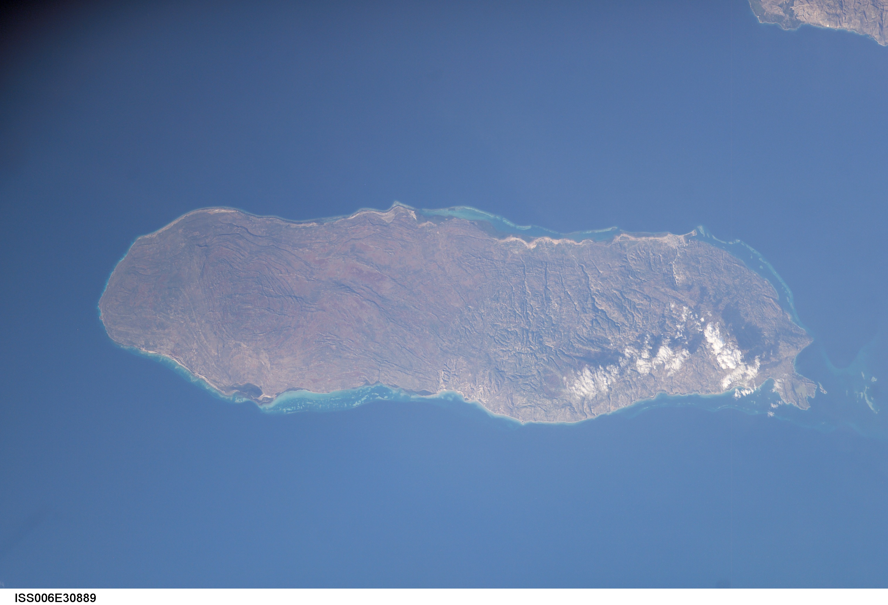
Gonave is 60 kilometers long and 15 kilometers wide, covering 743 square kilometers of mostly limestone terrain fringed by coral reefs. The highest point reaches 778 meters, but elevation brings little relief from the island's fundamental problem: water. Annual rainfall ranges from 800 millimeters in the lowlands to 1,600 millimeters at higher elevations, but the porous limestone does not hold it well. The barren, dry soil has long prevented significant agriculture and kept the population lower than geography alone would suggest. By 2015, approximately 87,000 people lived on the island, most of them in Anse-a-Galets. A severe drought in 2005 prompted the mayor to form the Water Platform, a coalition of aid organizations, churches, and civic groups dedicated to the singular problem of finding drinkable water. Groups like Haiti Outreach and Guts Church from Tulsa, Oklahoma, have financed and drilled wells across the island. By recent count, over 70 functioning water wells serve the population -- each one a small victory over the limestone.
Disasters Close and Far
Isolation has not spared Gonave from catastrophe. On September 8, 1997, the passenger ferry La Fierte Gonavienne -- The Pride of Gonave -- sank while crossing from the island to Montrouis on the Haitian mainland. The exact death toll was never established; estimates range from 250 to 290 passengers killed, with roughly 60 survivors. It remains the worst disaster in Haitian maritime history since the Neptune accident of 1993. When the 2010 earthquake struck Haiti on January 12, the island's docks were damaged, cutting off its primary supply route. Aid had to be airlifted to a 1,800-foot dirt strip. A coordinated relief effort raised $250,000, purchased 150 tons of rice and beans, medical supplies, building materials, and a backhoe, and shipped everything to Gonave by leased vessel. The shipment fed 50,000 people for a month. In the 1980s, British singer Cliff Richard wrote the song "La Gonave" to raise relief funds for the island -- a reminder that Gonave's struggles have drawn international attention for decades.
From the Air
Gonave Island sits at approximately 18.83N, 73.08W in the Gulf of Gonave, clearly visible as a large, distinct landmass between Haiti's northern and southern peninsulas. The island is roughly 60 km long and 15 km wide, running east-west. From cruising altitude, it is an unmistakable landmark: a barren, hilly mass surrounded by reef-fringed turquoise water. The dirt airstrip near Anse-a-Galets (approximately 1,800 feet) is visible on the eastern end. Nearest major airport is Toussaint Louverture International (MTPP/PAP) in Port-au-Prince, about 55 km to the southeast. St-Marc lies to the north across the Canal de Saint-Marc.