Goodwin Sands
When the tide draws back over the Goodwin Sands, ten miles of pale sandbank rise out of the English Channel six miles off Deal - long enough to drive a car on, briefly firm enough to play cricket on, and just slow enough at firming that the BBC's 2006 reconstruction crew had to be rescued by the Ramsgate lifeboat. The same sands have swallowed more than two thousand ships. Shakespeare put them in The Merchant of Venice as "a very dangerous flat and fatal, where the carcasses of many a tall ship lie buried." The Goodwins are the place where the English Channel keeps its secrets - and very occasionally hands one back.
Twenty-Five Metres of Sand on Chalk
Geologically, the Goodwins are a thin lid on a deep secret. Roughly twenty-five metres of fine sand sit on top of an Upper Chalk platform - the same chalk that breaks into the daylight as the White Cliffs of Dover a few miles to the south. The sand drowns and dries with the tide; most of the bank lies between half a metre above low water and three metres below it, with one channel cutting down to twenty. Currents reshape the shoals constantly. Charts go out of date. Buoys and lightvessels mark the edges - the East Goodwin and South Goodwin lights have been stationed there for centuries - because nothing stays still long enough to be charted any other way. The sand is also strangely preservative: in 2017, divers began excavating the Dutch East Indiaman Rooswijk, lost in 1740 with 237 people aboard, after the silt that had hidden her for almost three centuries began to shift away.
Earl Godwin's Drowned Estate
For centuries the name was explained by a story. In 1817 a survey by Trinity Board, drilling test holes for a possible lighthouse, found a layer of London clay beneath the sand. The geologist Charles Lyell - one of the founders of modern earth science - proposed that the Goodwins were the eroded remains of a clay island, like the Isle of Sheppey a little further up the Thames. A later writer named G. B. Gattie ran with the idea, weaving in old legends of a fertile low-lying island called Lomea that the Romans were said to have known as Infera Insula, the "Low Island." By Gattie's telling, Lomea had belonged in the early eleventh century to Godwin, Earl of Wessex - the most powerful nobleman of his age - and after his fall the land passed to St. Augustine's Abbey at Canterbury, whose abbot let the sea walls crumble. A great storm in 1099, recorded in the Anglo-Saxon Chronicle, supposedly drowned the island. Modern geology disagrees: the Strait of Dover opened in prehistory, and no Lomea is mentioned in the Domesday Book. But the name stuck, and so did the legend that somewhere under the wreckage of two thousand ships lies the lost estate of an English earl.
Two Thousand Ships
The reason the Goodwins are deadly is geography. They sit directly across the busiest shipping lane in the world, the Strait of Dover. The deep anchorage between the sands and the Kent coast - The Downs - is a refuge from foul weather, but the route in and out of it threads past the killing edge of the bank. The Great Storm of November 1703 alone wrecked at least thirteen men-of-war and forty merchantmen in The Downs, drowning 2,168 men - though the boatmen of Deal, rowing into the same gale, pulled 200 alive from the water. The 1740 wreck of the Rooswijk took nearly everyone aboard. In 1748 the Lady Lovibond is said to have gone down on the Goodwins; she has no contemporary record, only a legend that she reappears every fifty years as a ghost ship. In 1809 the Admiral Gardner went down carrying copper coins for Matthew Boulton's East India Company - thousands of which were salvaged off the seabed in 1985. In 1991 the Radio Caroline pirate radio vessel drifted onto the sands and effectively ended the era of British offshore radio. In 2013 a Dornier Do 17 bomber - shot down by RAF Defiants of 264 Squadron on 26 August 1940 and the sole surviving aircraft of its type in the world - was lifted whole from the seabed after seventy-three years.
Cricket on the Sands
The same surface that has drowned so many can, for an hour or two on the right summer day, hold a cricket match. In 1824 Captain K. Martin, Harbourmaster at Ramsgate, instituted the first known game on the Goodwins at low water. The annual fixture ran almost without break until 2003. The Royal Marines School of Music, while based at Deal, played its own summer match when the tide cooperated. In June 1994, Deal Striders ran a one-mile race on the sands in memory of the journalist Cliff Temple - around a hundred runners and spectators landed by cross-Channel hovercraft and raced a circuit in a punishing wind. London Marathon winner Mike Gratton came second to Matt de Freitas; Olympic steeplechaser Tom Buckner came third. In 2006 the BBC's Coast programme tried to film a re-enactment of the cricket match and underestimated the speed of the returning tide - the crew had to be rescued by the Ramsgate lifeboat. The Goodwins do not forgive timing errors.
What the Sands Remember
Plans to do something else with the Goodwins keep surfacing. In 1968 a port. In 1985 an airport on three reclaimed islands. In 2012 a £39 billion proposal for the United Kingdom's new hub airport, five offshore runways aligned to keep aircraft clear of the coast. In 2018 the Marine Management Organisation granted a licence to dredge three million tonnes of aggregate; conservationists fought back, the licence expired in 2022, no dredging happened. The sands keep their character partly because every attempt to tame them runs into the same difficulty: they will not stay where they are put. They drowned more than the Dutch East India Company, the Royal Navy, the East India Company, and the Luftwaffe over five hundred years. They have a place in Shakespeare, Melville, Kipling, Auden, Patrick O'Brian, and the James Bond novels. And on a clear day, when the bank surfaces and the lightvessels mark the deep water, ten miles of pale sand rise out of the Channel - a temporary island, very old in legend, hard and white and ringed by the masts of ships that never made it home.
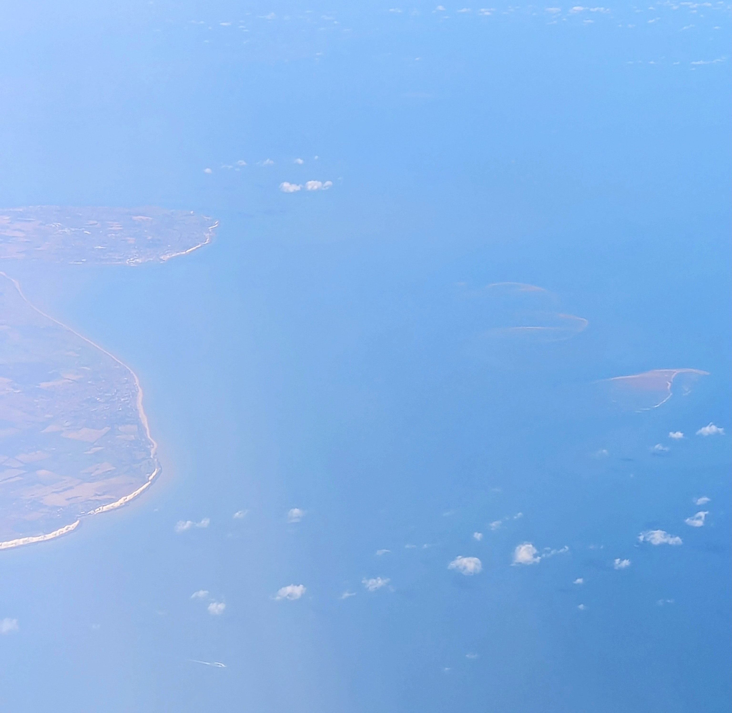
From the Air
Sandbank centered at approximately 51.27N, 1.51E, lying six miles off Deal and visible from cruising altitude as a long discoloration in the water at high tide or a pale crescent at low tide. Marked by East Goodwin and South Goodwin lightvessels. Heavy commercial traffic threads the adjacent Dover Strait shipping lanes. Nearest airports: Lydd (EGMD) to the southwest, Manston (EGMH, retired) just inland. Watch tidal timing - the sands surface for only a few hours around low water.