Goshikizuka Kofun: The Keyhole Tomb That Watched the Strait
From the top of the Goshikizuka Kofun, you can see Awaji Island across the Akashi Strait and the ships threading through the Seto Inland Sea. Whoever was buried here sixteen centuries ago chose this view deliberately. The tomb is shaped like a keyhole -- a circle joined to a rectangle -- and at 194 meters long, it is the largest burial mound in Hyogo Prefecture. It was built at the end of the 4th century or the beginning of the 5th, during the middle Kofun period, when powerful rulers across Japan constructed enormous earthen tombs to project authority over the living landscape. What makes Goshikizuka unique is not just its size but its restoration: this is the first kofun in Japan to be rebuilt to what archaeologists believe it originally looked like, its slopes covered in pale stones and lined with rows of clay cylinders, standing like silent sentinels above the water.
A Ruler Over Two Shores
The identity of the person buried in the Goshikizuka Kofun is unknown, but the tomb's location tells a story. Perched on the southern end of the Tarumi hills in western Kobe, it commands a direct view across the Akashi Strait to Awaji Island -- a strategic chokepoint controlling passage through the Seto Inland Sea. Archaeologists believe the tomb belonged to a ruler who controlled both shores of the strait. The construction's scale and method are comparable to the royal tombs of the Yamato court in Nara, and the mound's dimensions are nearly identical to the Sakiryoyama Kofun there. Yet the surrounding area shows no evidence of the economic base needed for such a massive project. This suggests the builder had strong ties to the Yamato Kingdom, perhaps serving as a regional lord who guarded the maritime corridor in exchange for central backing.
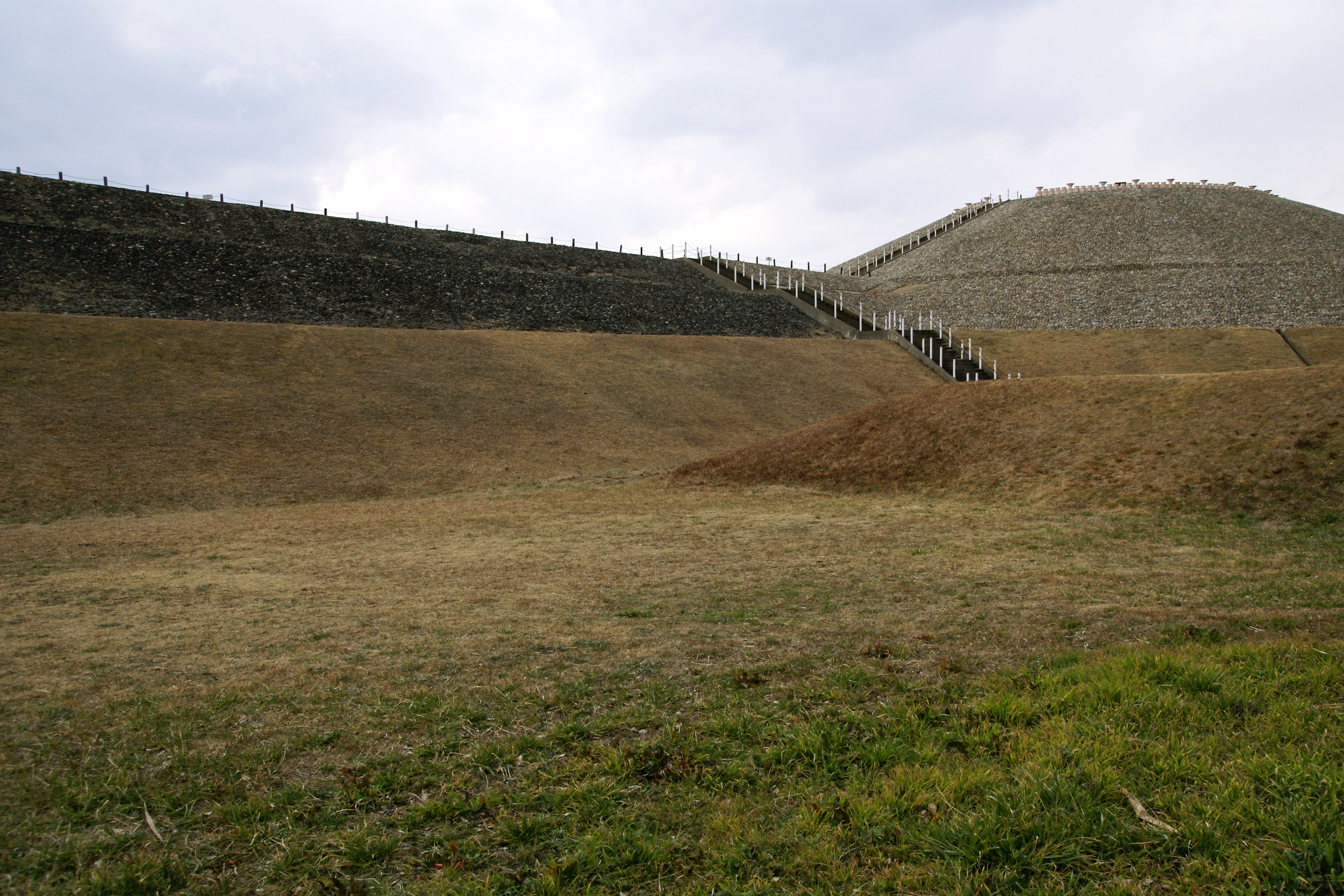
Two Million Stones from Across the Water
The Goshikizuka Kofun is built in three rising tiers, each slope armored with fukiishi -- riverbed stones carried to the site and laid across the earthen surface to prevent erosion and create a gleaming, imposing facade. The numbers are staggering: an estimated 2.23 million individual stones weighing approximately 2,784 tons. The upper and middle tier stones were transported from the northeastern coast of Awaji Island, ferried across the very strait the tomb overlooks. Crowning each tier are rows of cylindrical haniwa -- hollow clay figures that served as ritual boundary markers. Over 2,200 haniwa once lined the mound. The tomb is surrounded by double moats with shallow outer ditches, and three square island-shaped satellite mounds sit within the moat. The burial chamber itself has never been fully excavated, but fragments of crystalline schist originating in Tokushima Prefecture suggest a pit-type stone chamber inside.
Centuries of Protection, Then Loss
For centuries, the Goshikizuka Kofun survived because a pine forest grew over it, and local tradition -- dating at least to the early Edo period -- held that it was the tomb of Emperor Chuai, discouraging interference. The name 'Goshikizuka' itself is ancient and of uncertain origin. But World War II stripped the trees for timber, and the postwar years brought farming and urban development pressing against the mound. The tracks of the San'yo Main Line railway now pass directly in front of the tomb's rectangular end, and road construction destroyed portions of the surrounding moats. The neighboring Kotsubo Kofun, a large circular mound 70 meters in diameter and the second-largest enpun in the prefecture, fared somewhat better but also lost surrounding burial mounds to development. Together, the two tombs were designated a National Historic Site in 1921.
Rebuilt from the Earth Up
Excavation of the Goshikizuka Kofun began in 1965 and continued intermittently through 1993. What archaeologists found convinced them to attempt something unprecedented: a full-scale restoration to the tomb's original appearance. The reconstruction, completed in 1975, replaced the fukiishi on the slopes and reinstalled rows of replica haniwa along each tier. Walking the restored tomb today feels like stepping into the 5th century -- the pale stones glinting in the sun, the clay cylinders standing at attention, the green grass of the flat summit contrasting with the stone-covered slopes. In 2012, the excavated haniwa were collectively designated a National Important Cultural Property. The site is now an open archaeological park, reachable in ten minutes on foot from Kasumigaoka Station on the Sanyo Electric Railway. From the top, the view across the Akashi Strait to Awaji Island remains exactly what the tomb's builder intended visitors -- and rivals -- to see.
From the Air
Located at 34.63°N, 135.05°E on the Tarumi hills in western Kobe, overlooking the Akashi Strait. From altitude, the distinctive keyhole shape of the kofun is clearly visible -- a large circular mound joined to a rectangular front section, 194 meters in total length. The pale fukiishi stones covering the restored slopes create a lighter patch against the surrounding urban development. The Akashi-Kaikyo Bridge (the world's longest suspension bridge) spans the strait to the west and serves as a major visual landmark. The smaller circular Kotsubo Kofun sits adjacent. Nearest airport is Kobe Airport (RJBE) approximately 15 nautical miles east. Best viewed at 2,000-4,000 feet AGL approaching from the south over the Akashi Strait.