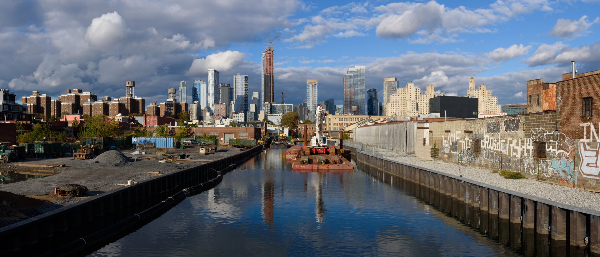
Gowanus Canal
In 2007, a young minke whale swam into the Gowanus Canal during a storm. Unable to navigate out of the narrow, fetid waterway, the whale died. Brooklynites nicknamed it "Sludgy." The name was apt. The Gowanus Canal is 1.8 miles of some of the most contaminated water in the United States -- a canal where fecal matter registers in parts per hundred rather than the usual parts per million, where the sediment layer of toxic sludge averages ten feet thick, and where the water's nickname since the early twentieth century has been "Lavender Lake" for its purplish hue. It is also, improbably, a canal undergoing a $506 million Superfund cleanup while luxury apartments and artisanal businesses crowd its banks. The Gowanus is Brooklyn in miniature: industrious, contaminated, gentrifying, and stubbornly alive.
Oysters and the Dutch
Before it was a canal, Gowanus Creek wound through tidal marshland where Dutch farmers settled and harvested large oysters, one of the area's first exports to Europe. The bay's six-foot tides pushed brackish water into the creek, creating ideal conditions for massive bivalves. Over generations, the largest oysters were harvested first, leaving the smaller ones to reproduce -- a case of negative artificial selection that gradually shrank the average size. In 1699, Nicholas Vechte built a stone farmhouse near the creek that would later become known as the Old Stone House. During the Battle of Long Island in 1776, American troops engaged the British near the house, buying time for Washington's retreat. The New York Legislature authorized widening the creek into a canal in 1774, and in 1849 a decree ordered it deepened into a 1.5-mile commercial waterway. Developer Edwin Litchfield undertook the straightening, and Army engineer Major David Bates Douglass designed the final canal, completed by 1869. The cheapest design was chosen. Proposals for lock systems that could have flushed the waterway daily were rejected as too expensive.
One Hundred Ships a Day
At its peak, as many as 100 ships a day moved cargo through the Gowanus Canal. Stone and coal yards, flour mills, cement works, tanneries, paint and ink factories, chemical plants, and manufactured gas facilities lined its banks. Every one of them dumped waste into the water. Chemical fertilizer manufacturing began along the canal shortly after the Civil War. By 1889, the pollution had become so severe that the New York Legislature appointed a commission to study the problem. The commission's recommendation was blunt: close the canal to commercial traffic and cover it over. They called it "a disgrace to Brooklyn." The first remediation attempt -- an 1890s sewer pipeline intended to carry waste out to the harbor -- proved inadequate. A larger tunnel completed by 1893, dubbed the "Big Sewer," was declared an "engineering blunder" by the Brooklyn Daily Eagle when it was discovered to be pushing sewage back into the canal rather than draining it out.
Lavender Lake
By 1910, the canal's water was described as almost solid waste. Bodies began turning up with unsettling regularity -- an unknown man in 1904, another in December of the same year, a missing man three weeks later. Urban legend holds that the Mafia used the canal as a dumping ground, and some cases are documented: a Brooklyn racketeer in the 1930s and a Grain Handlers Union president in the 1940s were both pulled from its waters. In a 1998 documentary called Lavender Lake, two police officers described fishermen hauling up a suitcase containing human body parts. After World War I, the canal handled six million tons of cargo annually, making it the nation's busiest commercial canal and arguably its most polluted. The flushing tunnel's intake fan broke in 1963. A year later, the Verrazzano-Narrows Bridge eliminated the need for industrial boats to use the canal at all, since trucks could now carry goods by road. H.P. Lovecraft, who lived nearby in the 1920s, described "the lapping oily waves at its grimy piers." The description still holds.
Superfund and Sludgy
Microbiologists testing the canal in 1974 found organisms that caused typhoid, cholera, dysentery, and tuberculosis. A 1981 study documented more than 13 million gallons of raw sewage entering the canal on an average day. In 2009, the environmental group Riverkeeper tested the water after heavy rain and found Enterococcus bacteria at 17,329 cells per 100 milliliters -- anything above 104 is considered unsafe. That same year, the EPA moved to designate the Gowanus Canal a Superfund site over the objections of the New York City government, which offered to conduct its own cleanup. On March 4, 2010, the canal was placed on the National Priorities List. The cleanup plan, approved in September 2013, calls for dredging approximately 588,000 cubic yards of contaminated sediment, capping the dredged areas, and controlling combined sewer overflows. The estimated cost is $506 million, to be paid by responsible parties including National Grid and the city. Pilot dredging uncovered a World War II crash boat, industrial wooden bobbins, and nineteenth-century wagon wheels buried in the toxic muck.
What Grows in Lavender Lake
Restoration of the flushing tunnel in 1999 brought the first signs of aquatic life in decades. Within months, observers spotted pink jellyfish, blue crabs, and fish. By 2009, white perch, herring, striped bass, and anchovies had returned, though they carry toxins and are unsafe to eat. Herons, egrets, and bats have established themselves along the banks. On Earth Day 2015, environmental activist Christopher Swain swam the length of the canal in protective gear to raise awareness. He described it as the dirtiest body of water he had ever swum through: "mud, poo, detergent, oil and gasoline." Some of his skin was exposed to the biological and industrial waste despite his precautions. Meanwhile, the neighborhoods along the canal -- Carroll Gardens, Park Slope, Red Hook -- have become among Brooklyn's most desirable. Artists moved into cheap industrial spaces in the 1980s, followed by developers and rezoning proposals. A community oyster garden now operates in the canal, and volunteer canoeists log thousands of trips on the water each year. The Gowanus is being cleaned, built upon, and cautiously inhabited. Sludgy did not survive it. Brooklyn intends to.
From the Air
Coordinates: 40.6740°N, 73.9870°W. The Gowanus Canal runs 1.8 miles through western Brooklyn, visible from altitude as a narrow, dark-colored waterway cutting through dense urban fabric between the neighborhoods of Carroll Gardens, Park Slope, and Red Hook. Seven bridges cross it. Nearest airports: KJFK (JFK International, 17 km SE), KLGA (LaGuardia, 16 km NE). Best viewed at 2,000-4,000 ft AGL approaching Brooklyn from the west over Upper New York Bay.