Graaff-Reinet
The bar counter at the Graaff-Reinet Club still has bullet holes from the Anglo-Boer War. Ask the right person, and they will show you each one, along with the historical weapons on the walls, the caricatures of former members, and the general atmosphere of a place that has been pouring drinks since before most South African towns existed. Graaff-Reinet was established in 1786, making it one of the oldest towns in South Africa and the oldest in the Eastern Cape. It carries 220 declared national monuments, more than any other town in the country. In a nation that builds forward at tremendous speed, this Karoo settlement holds on to its past with unusual tenacity.
A Governor's Name, a Frontier's Purpose
The Dutch East India Company founded Graaff-Reinet to impose order on a frontier that had grown wild. Dutch farmers had pushed deep into the Eastern Cape, well beyond the reach of colonial authority in Cape Town, and the Company needed an administrative presence. They named the new settlement after the Governor of the Cape, Cornelius Jacob van de Graaff, and his wife Cornelia, whose maiden name was Reinet. The hyphenated result is one of the most distinctive town names in South Africa. For a time, Graaff-Reinet was one of the largest centers in the Cape Colony, positioned on the direct route to the diamond and gold fields of the interior. Wagon traffic poured through on its way to fortunes real and imagined. When the railway arrived and bypassed the town, Graaff-Reinet settled into its current role: an important farming center for Merino sheep, Angora goats, and ostriches in the eastern Great Karoo.
The Valley That Silence Built
Fourteen kilometers outside town, the earth drops away into dolerite columns that stand like the ruins of a cathedral no one designed. The Valley of Desolation is not a valley in the conventional sense but a landscape of pillars, some reaching 120 meters high, carved by millennia of erosion from the softer rock that once surrounded them. The Karoo sun bakes the stone into shades of rust and amber, and the silence is so complete that you hear your own heartbeat. The valley sits within the Camdeboo National Park, which encompasses roughly 15,000 hectares of Karoo landscape. Mountain zebra, buffalo, and a wide variety of antelope move through the scrubland below the pillars. Birdwatchers come for the raptors that nest in the cliff faces. At sunset, the columns throw long shadows across the valley floor, and the sky turns through a sequence of colors that no photograph has ever fully captured.
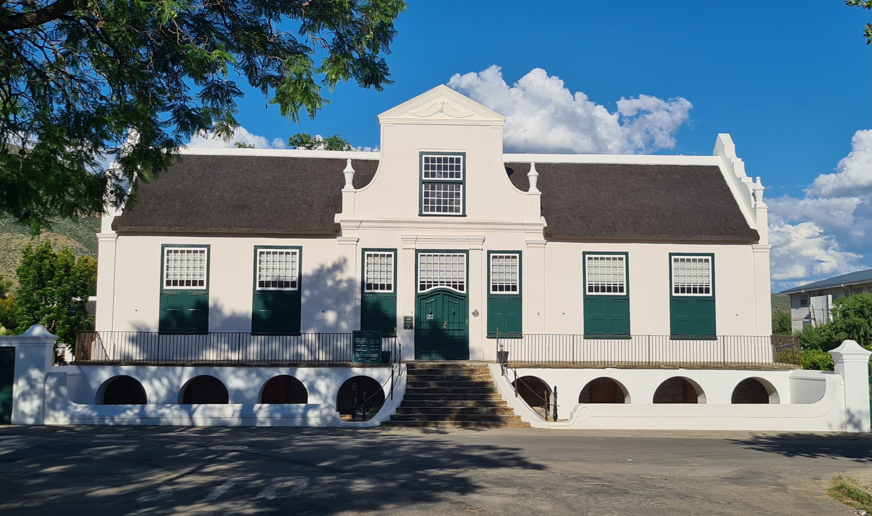
Monuments in Every Direction
Those 220 national monuments are not clustered in a museum district; they are the town itself. The Dutch Reformed Church dominates the center, its steeple visible from every approach road. Around it, Cape Dutch houses with their characteristic gables stand alongside Victorian and Karoo-style buildings in a jumble of architectural periods that somehow coheres. The Reinet House Museum, a Cape Dutch parsonage, is the most visited museum in the Eastern Cape. The Hester Rupert Art Museum holds contemporary South African art in a building with its own historical credentials. The Old Residency houses a firearm and war collection. Walk down Church Street and Caledon Street and the architecture tells the story of successive waves of settlers, administrators, and merchants who each left their mark in stone and plaster. McNaughton's Bookshop still carries Africana alongside tourist maps, the kind of shop that survives only in towns where the past is considered worth reading about.
Karoo Spirits
The Karoo's isolation has produced some unexpected things, including South Africa's only agave distillery. Somewhere in the district surrounding Graaff-Reinet, the agave plant that Mexicans turn into tequila grows in sufficient quantities to support a licensed distillery, the only one outside Mexico producing spirits from the plant. The local 'Withond,' or White Dog, is a variation of witblits, the South African moonshine that translates literally as 'white lightning.' This version is produced under special license on the premises of the Reinet House Museum, blurring the line between cultural preservation and a stiff drink. And then there is 'Karoo Cabernet,' which is not wine at all but brandy and Coke, the closest thing to red wine that some locals say they need. These are the products of a landscape too dry and too far from anywhere for pretension, a place where the nearest town of any size requires a long drive and the nearest meteorite crater requires only a short one.
From the Air
Coordinates: 32.25S, 24.54E. Graaff-Reinet sits in a distinctive horseshoe bend of the Sundays River in the eastern Great Karoo, visible from the air as a green oasis in semi-arid terrain. The Valley of Desolation's dolerite pillars are visible 14 km to the southwest within Camdeboo National Park. The Sneeuberg mountains rise to the north. The town is accessible via the N9 (north-south) and R63 (east-west). Nearest airports: Port Elizabeth (FAPE, 260 km south); Graaff-Reinet Airfield (FAGR) has a grass strip suitable for light aircraft. Terrain is semi-desert with clear visibility typical of the Karoo. Recommended viewing altitude: 3,000-5,000 ft AGL.