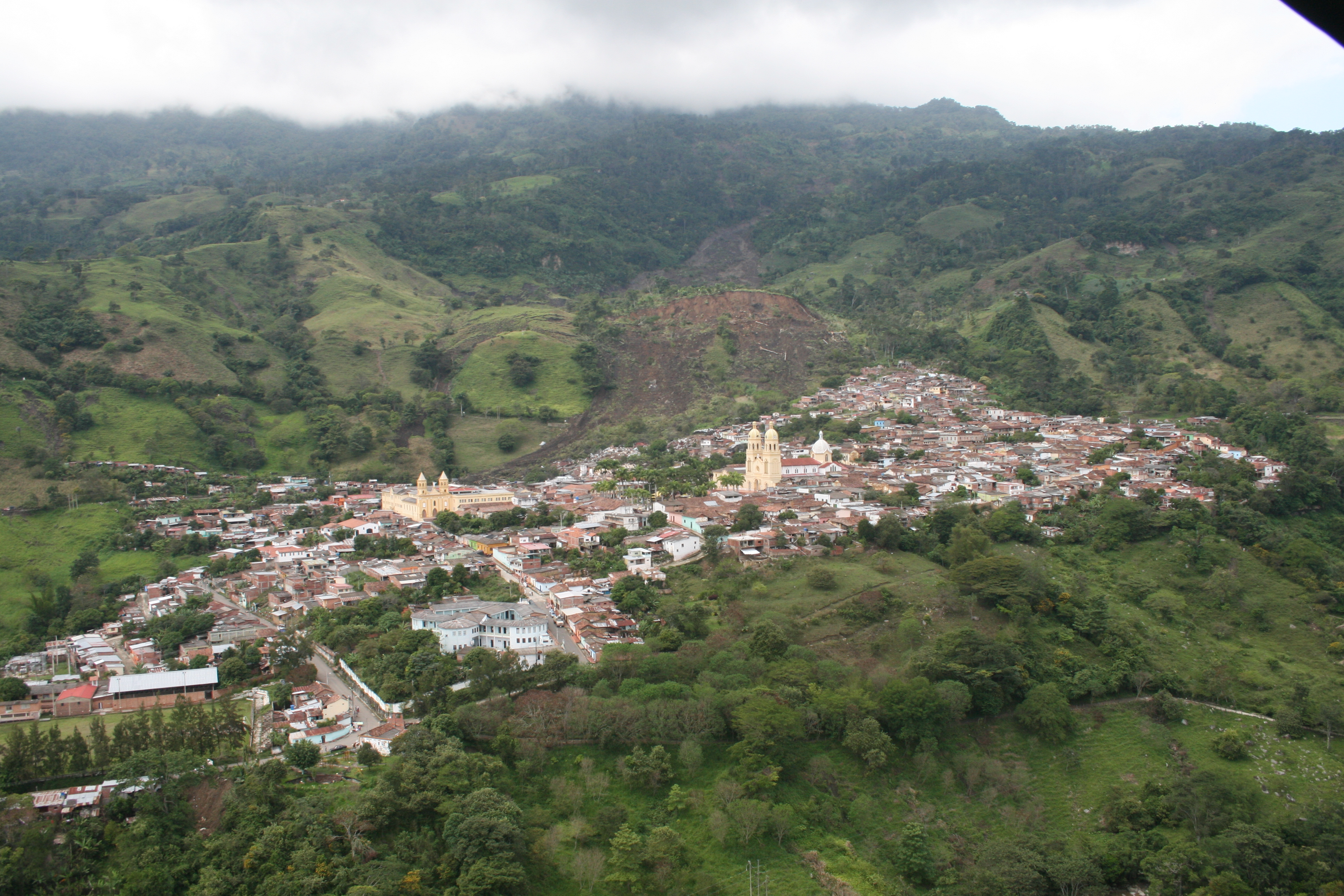
Gramalote
On December 16, 2010, the ground beneath Gramalote began to move. Not in a sudden, violent jolt, but in a slow, grinding rotation that gave the town's nearly 3,000 urban residents just enough time to flee before every building, every street, every corner of their lives crumbled into a hillside that had decided it was finished holding them up. The La Nina rains that year were relentless across Colombia, triggering floods and landslides nationwide. But what happened to Gramalote was singular: an entire municipality erased from the map, its population scattered overnight into temporary shelters across Norte de Santander.
A Town Founded Twice
Gramalote had always been stubborn about existing. Founded first in 1857, it was established again in 1883, relocated less than a kilometer south of the original site. Perched at 1,040 meters above sea level in the Colombian Andes, with an average temperature of 23 degrees Celsius, the town anchored a modest agricultural economy. Coffee accounted for over half of all income, followed by livestock at roughly a third. Panela, beans, bananas, and citrus filled out the rest. The state was the largest formal employer, with municipal government, schools, courts, and health services generating around 230 jobs. Before the disaster, 7,853 people called the municipality home.
The Earth Lets Go
The 2010 La Nina event dumped unprecedented rain across Colombia. In Gramalote, the saturated western hillside gave way in what geologists classified as a rotational landslide, a type of failure where a mass of earth pivots along a curved plane rather than simply sliding downhill. The destruction was total but mercifully slow. Over the course of hours, buildings buckled and streets split open, giving emergency responders time to evacuate the entire urban population. No one died in the collapse itself, a remarkable outcome given the scale. By the time the earth settled, Gramalote had joined a grim list: one of the eight largest displacement events caused by natural disasters worldwide between 2005 and 2015.
Years in Limbo
What followed the landslide was arguably harder than the disaster itself. The 3,400 urban residents dispersed to nearby municipalities, living in temporary housing while the Colombian government debated where and how to rebuild. The Ministry of Housing spent two full years selecting a site called Pomarroso before the decision was reversed. Residents pushed back, and after further technical and socio-political review, the government chose a different location: Miraflores, 3.5 kilometers northeast of the original town. In 2012, a new agency called Fondo Adaptacion was created specifically to manage reconstruction projects spawned by the La Nina catastrophe. The wait dragged on for years, testing the patience and cohesion of a community living in scattered exile.
New Gramalote Rises
On March 11, 2017, more than six years after the landslide, the first 54 families moved into the newly built town of Gramalote at Miraflores. Additional families followed throughout the year as houses, schools, and a hospital were completed, with 1,000 new homes expected by early 2018. The relocation became one of the most studied cases of post-disaster resettlement in the world, drawing researchers from universities and international organizations examining how communities rebuild identity and social fabric after total displacement. The original site, meanwhile, remains a ruin. The bones of Gramalote's churches, its plaza, the streets where the Brotherhood of the Nazarene once carried procession floats during Holy Week, all sit quietly disintegrating into the hillside that consumed them.
What Endures
The traditions that defined Gramalote survived the earth's betrayal. The Feast of Our Lady of Mongui, the town's patron saint, carries a history that stretches back to King Charles V of Spain, who commissioned paintings of the Virgin Mary to be sent to churches across the New World after his abdication in 1555. A copy of the Madonna del Rosario eventually reached Gramalote via Pamplona in 1861. The Christmas celebrations, from December 16 through Christmas Eve, still animate the community with float parades, lantern processions, and contests in the church atrium. Gramalote was destroyed, but the gramaloteros were not. They carried their festivals, their faith, and their coffee-growing expertise to a new piece of mountainside and started again.
From the Air
Coordinates: 7.92N, 72.79W, elevation approximately 1,040 meters (3,412 feet) in the Colombian Andes. The original destroyed town site and the new Gramalote at Miraflores (3.5 km northeast) are both visible from moderate altitudes. Nearest major airport is Camilo Daza International (SKCC/CUC) in Cucuta, approximately 60 km to the northeast. The terrain is mountainous with steep valleys typical of Norte de Santander. Best viewed in clear weather; cloud cover is frequent in this Andean region.