Grand Canyon: Two Billion Years in One Glance
Edward Abbey put it plainly: 'Those who love it call it the canyon. The canyon. As if there were no other topographic feature on the face of the Earth.' He was not exaggerating. The Grand Canyon is not the deepest canyon, not the widest, not the longest. Other canyons hold those records. But none of them silence visitors the way this one does. The Colorado River carved it over millions of years, cutting through rock layers that record two billion years of geologic history -- nearly half the age of the planet. The layers are stacked like pages in a book that nobody closed, preserved so perfectly by the dry desert air that geologists read them the way other people read newspapers. Theodore Roosevelt declared it a National Monument in 1908. It became a national park in 1919. Today it receives roughly 6.4 million visitors a year, and every single one of them walks to the rim and goes quiet.
Layers Like a Cake
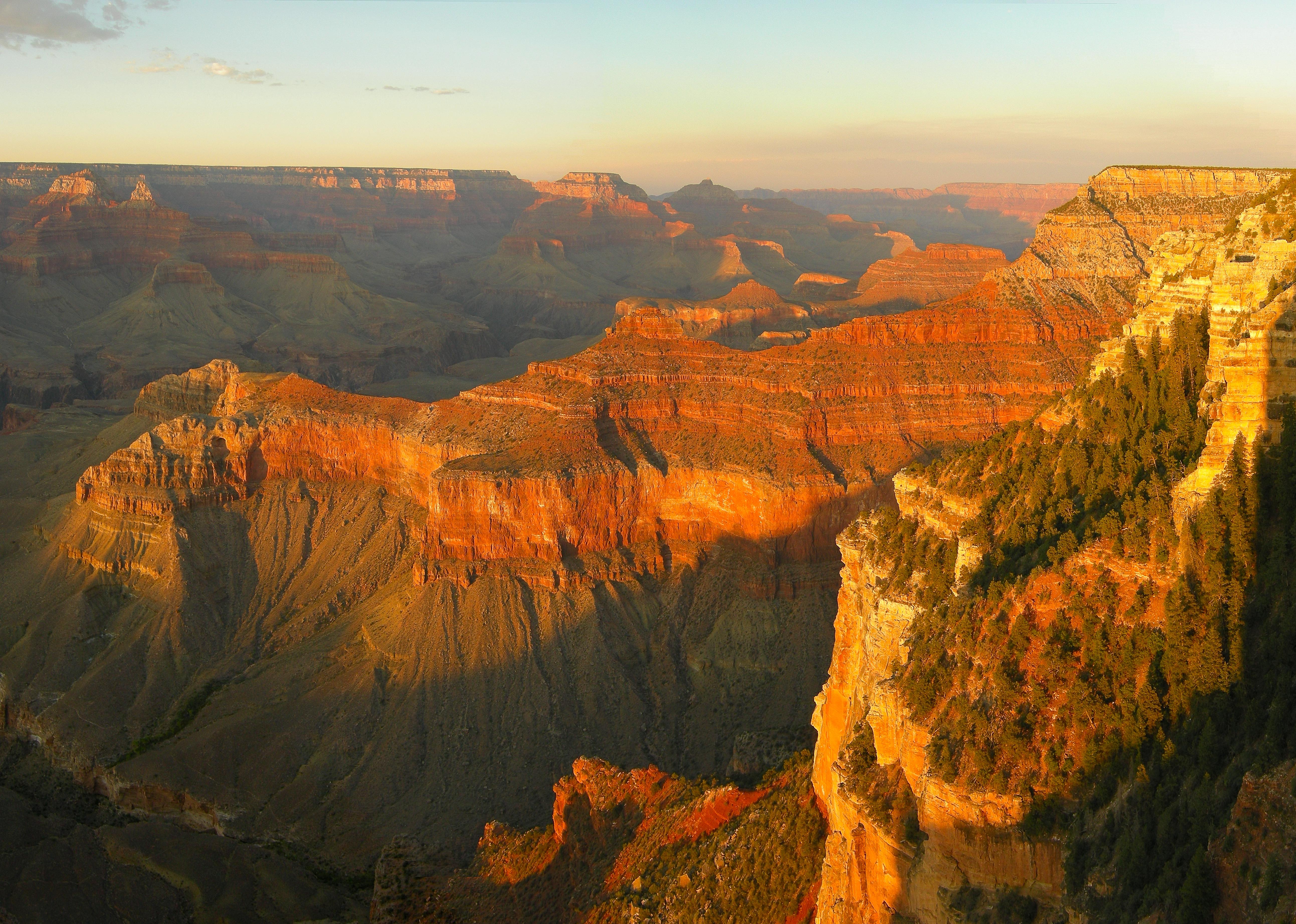
The Grand Canyon's geology reads from bottom to top like a compressed autobiography of Earth. The oldest exposed rock, the Vishnu Basement Rocks at the bottom of the inner gorge, formed nearly two billion years ago. Climbing upward through the canyon walls, each layer tells a different chapter: ancient seas, coastal dunes, swamps, deserts. The Coconino Sandstone records a vast Sahara-like desert 265 million years ago. The Kaibab Formation at the rim is limestone from a shallow sea 250 million years old. The layers are so distinct, so clean-edged, that the canyon functions as the most dramatic geology textbook on the planet. The desert climate keeps vegetation sparse, exposing the strata in bands of red, tan, gray, and white that shift color with the angle of the sun.
The River Below
The Colorado River still runs through the bottom, a mile below the rim. Whitewater rafting expeditions depart from Lees Ferry during summer months, with commercial trips lasting from 3 to 18 days. The river carved the canyon, but it also divides it. The North Rim sits roughly 1,000 feet higher than the South Rim, creating two fundamentally different ecosystems separated by a chasm. Driving from one rim to the other takes five hours and covers over 200 miles, even though they are only about 10 miles apart as the raven flies. Between them lies Phantom Ranch, accessible only by mule, on foot, or by raft -- the only lodging below the rim. Backcountry permits are required and fiercely competitive; space at the Bright Angel Campground fills on the first day reservations open.
A Canyon of Extremes
The Grand Canyon is a place of violent contrasts. It can be snowing on the rim while sunbathers warm themselves at the river a mile below. Summer temperatures on the North Rim run 20 to 30 degrees Fahrenheit cooler than at the river. July and August bring the Arizona monsoon -- thunderstorms that build fast, strike with lightning every few minutes, and trigger flash floods in side canyons with no warning. Hikers die here regularly, many of them young and fit, lured downward by the deceptive ease of descending. Unlike a mountain, where the hardest part comes first, the Grand Canyon saves its cruelty for the return trip. Each year over 250 people require rescue from the inner canyon due to exhaustion and dehydration. The park service posts warnings at every trailhead: do not attempt to hike to the river and back in a single day.
People of the Blue-Green Water
The canyon is not only a national park. Its southwestern reaches belong to the Havasupai Indian Reservation, where the name translates to 'People of the Blue-Green Water.' The Havasupai have lived in and around the canyon for at least 800 years. Their village of Supai, population around 200, is the most remote community in the contiguous United States -- reachable only by helicopter, horseback, or an eight-mile hike from Hualapai Hilltop. Below the village, Havasu Creek plunges over a series of spectacular turquoise waterfalls. The Hualapai Nation occupies the western end of the canyon and operates Grand Canyon West, including the glass-bottomed Skywalk that extends 70 feet over the canyon rim. These tribal lands remind visitors that the canyon held meaning and supported life long before it became a park.
From the Air
Airplane and helicopter tours depart from Tusayan at the Grand Canyon Airport and from Las Vegas. Scenic flights are no longer permitted below the rim within the national park, a restriction that preserves the silence of the canyon's interior. But from above, the scale becomes comprehensible in a way that rim viewpoints cannot achieve. The side canyons branch like a river delta. The Colorado appears as a thin green thread. The color bands of the rock layers wrap around buttes and temples with the precision of contour lines on a map. The Grand Canyon Railway still runs historic steam locomotives from Williams to the South Rim, a two-and-a-half-hour journey through ponderosa forest. The canyon itself remains invisible until the last moment, when visitors step to the rim and the earth drops away.
From the Air
Located at 36.05N, 112.14W in northern Arizona. The Grand Canyon is visible from cruising altitude in clear weather as a massive branching chasm cutting through the Colorado Plateau. The South Rim village area and Grand Canyon Airport (KGCN) at Tusayan are on the south side. Flagstaff Pulliam Airport (KFLG) is the nearest commercial airport, roughly 75 miles southeast. Las Vegas McCarran (KLAS) and Phoenix Sky Harbor (KPHX) are the nearest major airports. Scenic overflight restrictions apply within the national park -- check NOTAMs. Summer monsoon season (July-August) brings rapidly building thunderstorms with severe turbulence. The North Rim is approximately 1,000 feet higher than the South Rim.