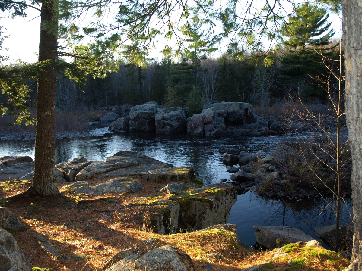
Grandfather Falls
In 1849, two Ojibwe men named Black Nail and Crow stood at the top of the most fearsome stretch of the Wisconsin River. Before launching their bark canoe into the cascade, Black Nail offered a prayer and a gift to the spirit of the falls: two yards of scarlet broadcloth and a brass kettle, thrown into the churning water. Then he seized his paddle and the canoe shot forward, bounding over the billows. They ran the falls in safety. No one ever tried again. Grandfather Falls drops 89 feet across roughly a mile of pre-Cambrian bedrock, making it the highest waterfall on the Wisconsin River. The Ojibwe called it Konajewun -- "long falls." French voyageurs named it Taureau Grand-pere, the Grandfather Bull, following their tradition of calling every set of rapids on the upper Wisconsin some version of "bull." Today most of that thundering water is diverted through a canal and penstocks to feed hydroelectric generators, but the ancient rock and the stories it carries remain.
A Tradition of Bulls
The naming convention tells its own story of exploration. Voyageurs working for John Baptiste DuBay, who ran a trading post for John Jacob Astor's American Fur Company near Fort Winnebago, traveled the Wisconsin River trading with Ojibwe communities as far south as the Yellow River. When they hit the rapids at Mosinee, they called them Taureau -- French for "bull." The larger rapids at what is now Wausau became Gros Taureau, Big Bull. Forty miles further upstream, they encountered a cascade so immense it dwarfed everything before it. They named it Taureau Grand-pere -- the Grandfather Bull. The name stuck, spawning a tradition that attached "Bull" to nearly every falls on the upper Wisconsin: Big Bull Falls at Wausau, Jenny Bull Falls at what is now Merrill. Beneath these French names lay older Ojibwe ones, and beneath those, the rock itself -- pre-Cambrian bedrock from when northern Wisconsin was an alpine mountain range, hundreds of millions of years old, scoured and exposed by glaciers.
The Great Log Jam
Before railroads penetrated the north woods, the Wisconsin River was the highway for the lumber industry. Logs cut in the vast pineries were banked along tributaries through the winter, then driven downstream to the sawmills each spring. Lumber rafts -- literally floating platforms of boards bound for Saint Louis and other Mississippi River cities -- carried finished product to market. The work was brutal and dangerous. Workers riding the rafts through rapids sometimes watched their cargo smash into splinters, and the men themselves were often killed. Grandfather Falls was virtually impassable for lumber rafts, which made Merrill the northernmost sawmill town by default. But even loose logs jammed catastrophically. The largest log jam in Wisconsin history formed at Grandfather Falls: 80 million board feet of timber backed up for miles, a floating wall of wood choking the river. The problem was so economically significant that it made front-page news across the state, reported with the same urgency that modern papers give to shipping disruptions or oil prices.
The Village Called Champagne
In 1880, a lumberman named Peter B. Champagne saw opportunity in the upper flushing dam at the falls. He enhanced the dam, built a mill race on the east side, and erected a sawmill. Where the sawmill went, workers followed, and where workers gathered, a town appeared: a livery stable, a boarding house, a store, a saloon, and a post office that took Champagne's name. The village of Champagne -- also called Grandfather Falls -- became a way station on the road north into the wilderness, a place for loggers, surveyors, and commercial travelers heading as far as Ontonagon, Michigan, to rest, eat, and water their horses. The town's life was tied to the river economy, and when railroads arrived -- the Milwaukee Road to the east, the Soo Line running east-west to the north -- that economy shifted overnight. Tomahawk and Rhinelander boomed as upstream sawmill towns could ship lumber directly by rail. The downstream mills declined. Log drives disappeared. Champagne faded from the map, though the paper industry rose to replace lumber as the north woods' economic engine.
Harnessing the Grandfather
In 1938, Wisconsin Public Service Corporation began a major project to capture the full 90-foot drop for electricity. Construction crews carved a canal along the east bank of the river, diverting water to two intake ports that feed massive penstocks. These steel tubes carry the water roughly a third of a mile horizontally and 92 feet vertically downward to a power plant at the base. Two generators convert the falling water into approximately 17 megawatts of electrical power -- the highest output of any hydroelectric plant that WPSC wholly owns. Twin surge towers rise above the plant, dampening the flow to extract maximum energy from the gravitational force of the water. The diversion means that today, except during spring snowmelt, only a fraction of the river's flow actually runs over the historic cascade. The falls still exist, still tumble over pre-Cambrian rock, but they are quieter than the Grandfather Bull the voyageurs named. The Wisconsin Ice Age Trail passes nearby, and Camp New Wood County, built on the site of a historic Civilian Conservation Corps camp, offers primitive camping and river access a few miles south.
A River's Legal Identity
Grandfather Falls played an unlikely role in constitutional law. The Wisconsin River holds the legal designation of "navigable river of the United States," which places it under congressional authority via the Commerce Clause. The falls themselves were central to a case testing that designation. Plaintiffs argued that because logs could be driven over the falls but lumber rafts could not, the commerce above and below the falls was fundamentally different -- intrastate above, interstate below. The court disagreed, ruling that sawing logs into lumber and changing the mode of transportation did not divide the journey from the pineries to market into two separate trips. The practical consequence: every dam on the Wisconsin River, including the hydroelectric project at Grandfather Falls, requires licensing from the Federal Energy Regulatory Commission. The falls that once stopped lumber rafts and jammed 80 million board feet of logs now generate electricity under federal oversight -- a far quieter role for a stretch of river that once defined the economic geography of an entire state.
From the Air
Located at 45.31°N, 89.78°W in Lincoln County, Wisconsin, along the Wisconsin River. The falls and hydroelectric facility are visible as a break in the river's flow with a canal diversion along the east bank. Look for the two surge towers rising above the power plant at the base of the falls. The Wisconsin River is a prominent landmark threading through the forested terrain of north-central Wisconsin. Wausau Downtown Airport (KAUW) is approximately 25 miles to the south-southeast. Rhinelander-Oneida County Airport (KRHI) is about 25 miles to the northeast. Best viewed at 2,000-4,000 feet AGL to see the full mile-long cascade and the canal diversion. The surrounding terrain is heavily forested second-growth hardwood and conifer, typical of the Wisconsin north woods. The Ice Age Trail passes nearby.