Great Australian Bight
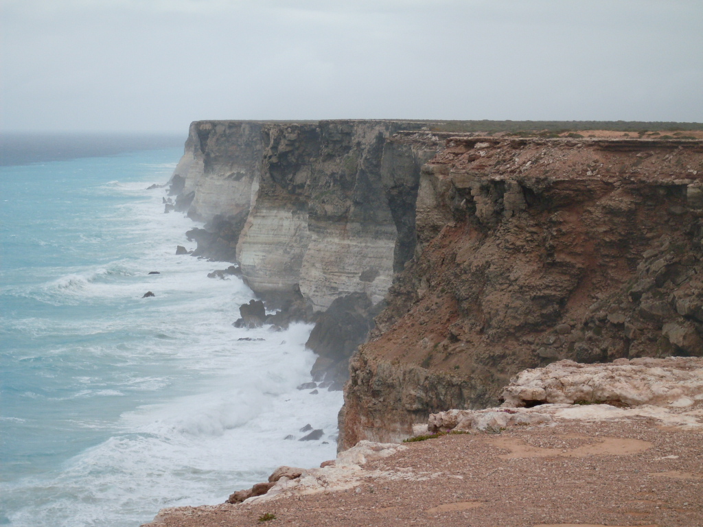
Fifty million years ago, the supercontinent Gondwana tore itself in two along what is now Australia's southern edge. Antarctica drifted south. Australia drifted north. And the ocean rushed in to fill the wound, creating the Great Australian Bight -- a sweeping arc of open water stretching more than 1,100 kilometers along the continent's underbelly. The cliffs here rise 60 meters straight from the sea, their limestone faces carved by swells that have rolled uninterrupted from the Antarctic. It is a coastline built by separation, and the life it sustains is astonishing.
Where the Continent Crumbles
The Bight's coastline is a study in geological drama. Limestone cliffs, aeolianite formations shaped by ancient winds, drop sheer into water that churns white and cold below. Rocky capes alternate with surfing beaches and wave-cut platforms. The Nullarbor Plain -- that immense, treeless limestone flatland -- runs right to the cliff edge and simply stops, as if someone sliced the continent with a knife. From the Head of the Bight, where the escarpment turns inland to the northeast, the coast softens into the bays and islands of the western Eyre Peninsula: Fowlers Bay, Smoky Bay, Streaky Bay, and the scattered rocks of the Nuyts Archipelago. The southern Eyre Peninsula reveals even older bones -- granitic outcrops of the Gawler Craton, some of the most ancient exposed rock on the continent.
The Engine Beneath the Surface
The Bight's waters appear nutrient-poor at first glance. The Nullarbor contributes no rivers, no runoff, no terrestrial nutrients. Yet each summer and autumn, deep ocean currents well up along the Eyre Peninsula coast, pushing cold, nutrient-rich water toward the surface. These upwelling events ignite a chain reaction: phytoplankton blooms, zooplankton swarms, and massive schools of sardine and anchovy -- the densest concentrations of small planktivorous fish in Australian waters. Juvenile southern bluefin tuna migrate into the Bight annually to gorge on this abundance. The macroalgal assemblage alone exceeds 1,200 species, making it one of the most diverse on Earth. Over 90 percent of invertebrate species in the region are endemic to southern Australia, found nowhere else.
The Whale Nursery
Each winter, southern right whales make the long journey from their Antarctic feeding grounds to the sheltered waters of the Bight. They come not to eat -- they will fast until they return south -- but to calve and breed. The Head of the Bight, where the cliffs curve inward, offers a natural amphitheater for watching them. Mothers and calves surface within meters of the cliff base, close enough that their exhalations carry on the wind. Nineteenth-century whaling nearly annihilated these animals, and their recovery has been slow. But their numbers are increasing, and the Bight has become one of Australia's premier whale-watching destinations. Standing on those cliffs in July, watching a 50-ton animal roll gently with her newborn in the swell below, the scale of the place makes sudden, visceral sense.
Charting the Unknown Shore
Dutch navigator Francois Thijssen was the first European to encounter the Bight, sailing along its western margins aboard the Gulden Zeepaert in 1627. It would be another 175 years before anyone mapped it properly. In 1802, English navigator Matthew Flinders charted the coastline during his circumnavigation of Australia, naming bays, capes, and headlands with the methodical precision of a man who knew he was writing the map for everyone who followed. Edward John Eyre later surveyed the coast by land, an endeavor that nearly cost him his life. For the Indigenous peoples who had lived along this coast for tens of thousands of years, of course, none of it needed naming or discovering. The Bight was already known.
The Fight Over What Lies Below
Since the 1960s, the petroleum industry has eyed the Bight's continental shelf. In the mid-2010s, three oil majors -- BP, Equinor, and Chevron -- proposed exploration drilling in its deeper waters. The response was fierce. Environmental modeling by the Wilderness Society demonstrated that a worst-case oil spill could devastate the entire southern Australian coastline. The Australian Senate launched an inquiry in February 2016. BP withdrew that October, citing strategic misalignment. Chevron pulled out in 2017, returned briefly alongside BP in 2019, and then Equinor -- the last company standing -- abandoned the project in February 2020, citing profitability. For now, the Bight remains undrilled. The upwelling continues. The tuna still come. The whales still calve beneath the cliffs.
From the Air
Centered at approximately 33.00S, 130.00E. From altitude, the Great Australian Bight appears as a vast crescent of deep blue water meeting the tan-white line of the Nullarbor cliffs. The Bunda Cliffs are striking from above -- a sharp, continuous edge where flat land meets ocean. The Eyre Peninsula and its bays are visible to the east. Nearest airports: Ceduna (YCDU), Adelaide (YPAD). Conditions are frequently clear, though Southern Ocean weather can bring sudden fog and low cloud along the coast.