Great Dismal Swamp
William Byrd II hated it. Sent in 1728 to survey the boundary line between Virginia and North Carolina, he slogged through the mire, swatted insects, and gave the place the name it still carries: the Dismal Swamp. But the people who fled here, the Native Americans pushed from their lands by colonial expansion and the thousands of enslaved African Americans who escaped into its trackless interior, knew it as something else entirely. To them, this dark labyrinth of bald cypress, tupelo, and tea-colored water was freedom. Sprawling across the coastal plain between Norfolk, Virginia, and Elizabeth City, North Carolina, the Great Dismal Swamp has been many things across thirteen millennia of human habitation: hunting ground, refuge, industrial timber yard, and, since 1974, a federally protected wildlife sanctuary covering more than 167 square miles.
Thirteen Thousand Years of Footprints
Archaeological evidence places humans in the swamp as far back as 13,000 years ago. By the time English settlers established Jamestown around 1600, the Powhatan empire extended to the swamp's northern edge, having displaced the Chesapeake tribe before them. Algonquian-speaking coastal peoples lived within the swamp by 1650. The first European recorded to encounter its central lake was William Drummond, the inaugural governor of North Carolina, in 1665. The lake that bears his name remains a mystery: no obvious network of natural streams feeds it, and its origins have puzzled geologists for centuries. Drummond's discovery opened the swamp to European interest, but taming it proved another matter. The landscape resisted every attempt at orderly exploitation, its waterlogged terrain swallowing roads and rotting foundations.
The Hidden Nation
The swamp's most extraordinary chapter belongs to its maroon communities. As the Atlantic slave trade brought enslaved people to Virginia's plantations, some escaped into the Dismal Swamp, where the dense vegetation and treacherous footing made pursuit nearly impossible. By 1860, thousands of Black refugees had built lives on the scattered islands of dry ground amid the wetland. J.D. Smyth, writing in 1784, described runaways who had lived in the swamp for twelve, twenty, even thirty years, raising corn, hogs, and fowl on patches of land that sat above the floodwaters. Archaeological excavations have uncovered evidence of whole island communities that persisted until the Civil War. One maroon named Charlie, who worked illegally in a lumber camp within the swamp, later recalled entire families living in the Dismal who had never seen a white man. These communities represented one of the largest and longest-lasting settlements of escaped enslaved people in North America. In 2012, the Underground Railroad Education Pavilion opened at the refuge to tell their story.
The Canal That Wouldn't Die
Commerce found its way into the swamp through water. Virginia authorized the Dismal Swamp Canal in 1787 and North Carolina followed in 1790. Construction began in 1793, and the twenty-two-mile channel was completed in 1805, creating a trade route between Chesapeake Bay and Albemarle Sound. A railroad cut through part of the swamp in 1830, and together, canal and rail enabled massive timber harvesting that would devastate the ecosystem for over a century. The canal declined after the competing Albemarle and Chesapeake Canal opened in 1858, but refused to disappear. The federal government purchased it in 1929 and began improvements. Today, the Dismal Swamp Canal is the oldest continuously operating artificial waterway in the United States and forms part of the Atlantic Intracoastal Waterway, still carrying boats between the two states just as it did more than two centuries ago.
A Living Wilderness Reclaimed
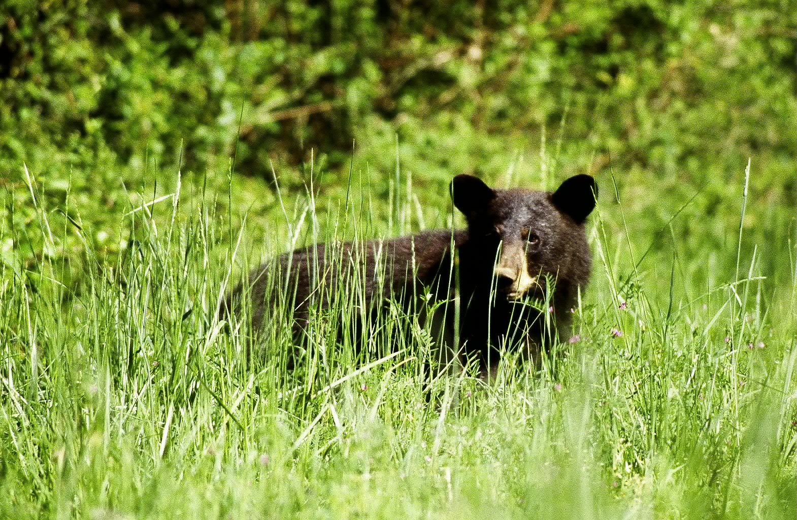
Centuries of logging, draining, and farming had reduced the Great Dismal Swamp to a fraction of its original extent. The turnaround came in 1973, when the Union Camp Corporation of Franklin, Virginia, donated a large tract of devastated swampland. The Dismal Swamp Act of 1974 formally established the Great Dismal Swamp National Wildlife Refuge. Today, the refuge harbors bald cypress, tupelo, Atlantic white cypress, maple, and pine forests that support a remarkable variety of wildlife: black bears, bobcats, otters, weasels, more than seventy reptile and amphibian species, and 213 bird species, including 96 that nest within the swamp. A botanical survey in the 1970s documented 334 plant species from 100 families. Water control structures in the old drainage ditches now work to conserve water rather than remove it, and forest management mimics the ecological effects of natural wildfires to restore plant diversity. Lake Drummond, the swamp's dark heart, draws fishermen, birders, and boaters, though camping is not permitted on the refuge.
Dismal Only in Name
From the air, the Great Dismal Swamp is a vast green canvas pressed between the suburban sprawl of Hampton Roads and the farmland of northeastern North Carolina. The dark water that gives the swamp its brooding character gets its color from tannins leaching out of juniper and cypress bark, a natural staining that has been happening since long before any human set foot here. Byrd's dismissive name stuck, but it never captured the truth. This is a place where freedom was found in trackless bogs, where a canal outlasted the empire that built it, and where a damaged ecosystem is slowly stitching itself back together. The Dismal Swamp earned its name from a surveyor who wanted to be somewhere else. It has spent the centuries since proving him wrong.
From the Air
Located at 36.64N, 76.45W, the Great Dismal Swamp is a vast, flat wetland straddling the Virginia-North Carolina border. From altitude, it appears as a dark green expanse contrasting sharply with surrounding farmland and urban development. Lake Drummond is visible at the center as a distinctive oval body of dark water. The Dismal Swamp Canal runs along the eastern edge. Nearest airports include Norfolk International (KORF) approximately 25nm north and Elizabeth City Regional (KECG) approximately 25nm south. Fly at 3,000-5,000 feet AGL for the best perspective on the swamp's full extent. The swamp is a National Wildlife Refuge; low-altitude overflights should respect wildlife disturbance guidelines.