Great Falls of the Missouri River
Meriwether Lewis heard them before he saw them. On June 13, 1805, advancing across the Montana plains, his ears caught "the agreeable sound of a fall of water," then spotted spray rising "above the plain like a column of smoke." When he finally scrambled down a 200-foot bluff to witness the Great Falls of the Missouri, the usually methodical explorer ran out of words. He wished for "the pencil of Salvator Rosa" to capture the scene, calling it "the grandest sight I ever beheld." Lewis had stumbled upon one of the most significant geographic discoveries of the expedition: a series of five waterfalls stretching ten miles along the upper Missouri, a formidable barrier that would demand an 18-mile portage and reshape the expedition's timeline.
Names Written in Mist
The Mandan called them Minni-Soze-Tanka-Kun-Ya, meaning simply "the great falls." The South Piegan Blackfeet had a more evocative name for one cascade: "Napa's Snarling." Lewis and Clark added their own poetry to the landscape. They christened one waterfall "Beautiful Cascade" for the rainbows dancing in its mist, later renamed Rainbow Falls by a railroad engineer in 1872. Another became Crooked Falls for its angular plunge. The "Upper Pitch" would eventually become Black Eagle Falls, named for the dark birds that still circle its spray. Each name carried a layer of human encounter, from Paleo-Indians who first witnessed these waters between 9,500 and 8,270 BCE to the 19th-century explorers who saw them as both obstacle and wonder.
Shaped by Ice and Time
The falls owe their existence to a collision of ancient forces. The Missouri River flows atop the Great Falls Tectonic Zone, a shear zone between two Archean-period basement rocks that form part of the North American continent. About 1.5 million years ago, the Missouri, Yellowstone, and Musselshell rivers all flowed northward into a terminal lake. Then came the ice. During the last glacial period, the Laurentide and Cordilleran ice sheets pushed these waterways southward. Between 15,000 and 11,000 BCE, glaciers blocked the Missouri and created Glacial Lake Great Falls. Around 13,000 BCE, as the ice retreated, the lake emptied catastrophically in an outburst flood of almost unimaginable power. The falls themselves formed where the river encounters the Kootenai Formation, a mostly sandstone layer. The water erodes the softer rock while harder formations create the cascades that thundered for millennia.
The Portage That Changed Everything
For Lewis and Clark, the falls were beautiful but merciless. Over 80 feet high and stretching 300 yards wide at the main cascade, the five waterfalls made navigation impossible. The expedition spent nearly a month hauling boats and supplies around the falls on cottonwood wheels, suffering sunstroke, hailstorms, and encounters with grizzly bears. Yet the falls also delivered discoveries. Expedition member Silas Goodrich caught Westslope cutthroat trout here, specimens that would become the type for the species, later named Oncorhynchus clarki lewisi in honor of both explorers. William Clark discovered Giant Springs, correctly judging it the largest spring in the world. The Great Falls Portage is now a National Historic Landmark District, designated in 1966 to commemorate the grueling route that nearly broke the expedition before it reached the Pacific.
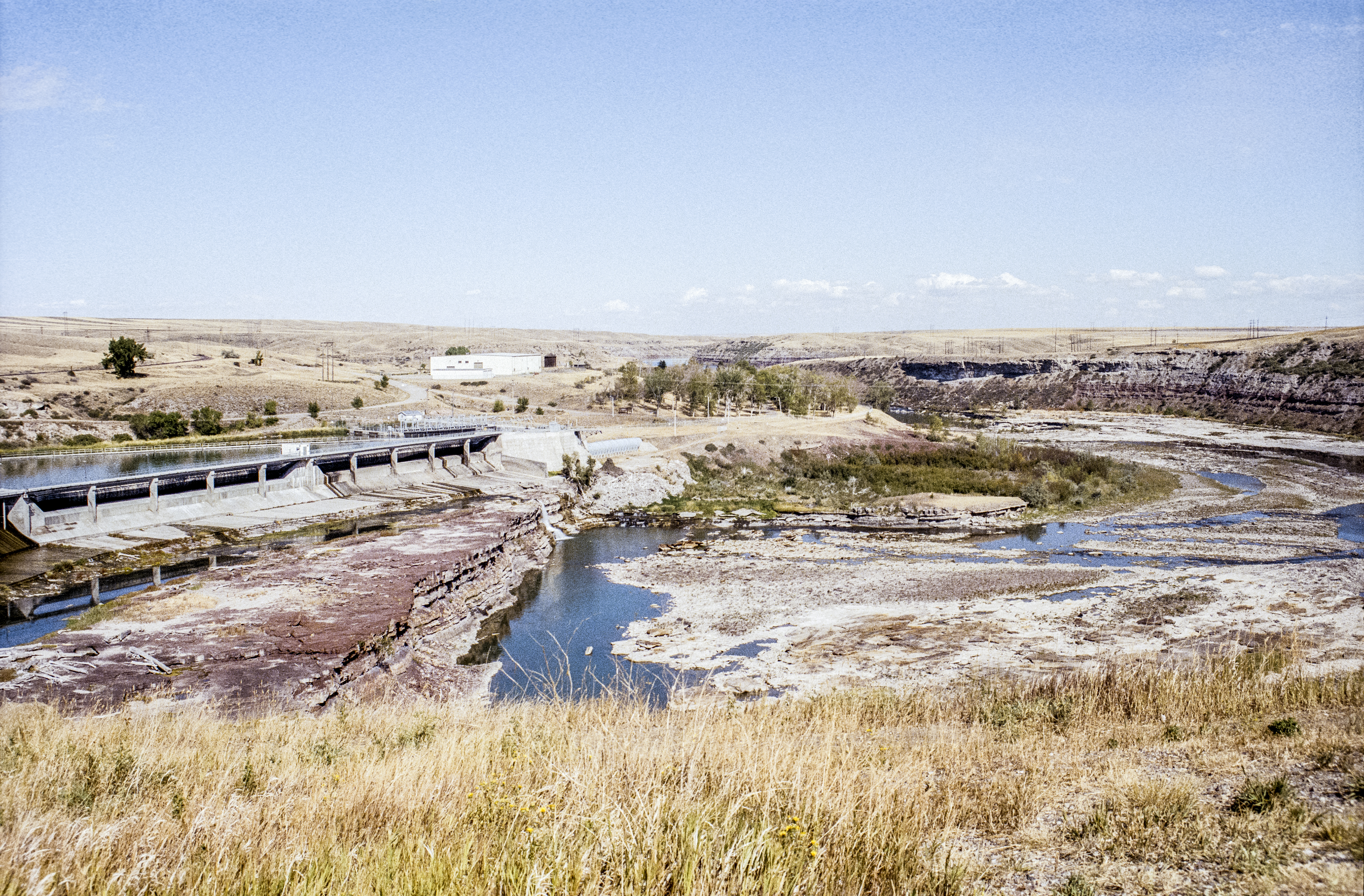
Taming the Thunder
Today, only one of the five waterfalls exists in its natural state. Crooked Falls alone remains undammed, a lonely survivor of the hydroelectric age. Black Eagle Dam went up in 1890, submerging half of its namesake falls behind a reservoir. Rainbow Dam followed in 1910, forever altering the cascade Lewis found so enchanting. The dams brought electricity to the city of Great Falls, founded in 1883 by businessman Paris Gibson on the south bank of the river. Fort Benton, established in 1846 about 40 miles downstream, had marked the limit of Missouri River navigation. Steamboats could travel no further than these falls, making this stretch of water both barrier and boundary. The first steamboat arrived in 1859, the same year the first photograph captured the cascades that Lewis had declared "second to but one in the known world."
The River's Edge
The Lewis and Clark National Historic Trail Interpretive Center, built in 1998 on a cliff overlooking the Missouri near Crooked Falls, offers a window into what the explorers encountered. The River's Edge Trail follows the portage route they blazed, a paved path connecting the city of Great Falls to the town of Black Eagle. The falls appear on Montana's state seal, adopted in 1893, a permanent reminder of their significance to the region's identity. For visitors today, the experience is different from what Lewis described, but the river still commands attention. The water still flows over ancient rock, still catches light in spray, still marks the place where two explorers paused to marvel at a landscape that defied their ability to describe it.
From the Air
Located at 47.57N, 111.12W in north-central Montana. From altitude, the sequence of five falls and dams is visible stretching along the Missouri River. Nearby airports include Great Falls International Airport (KGTF) approximately 4 miles southwest. The river corridor and dam structures create clear visual landmarks. Best viewed at 3,000-5,000 feet AGL for context of the entire falls series.