Great Sioux Reservation
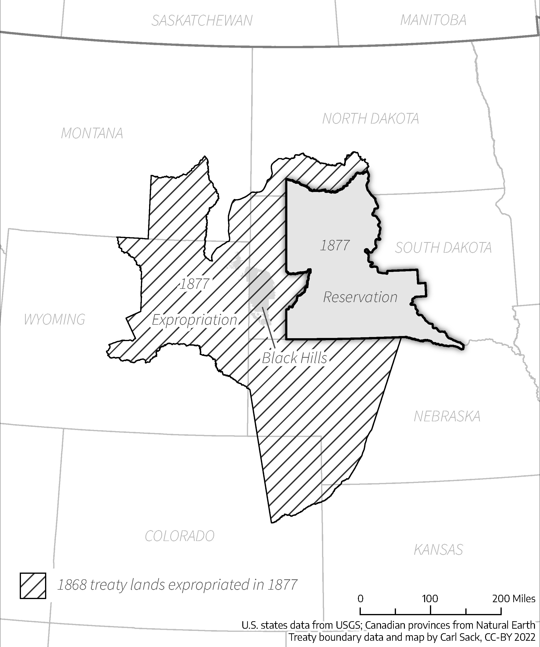
In 1868, the Fort Laramie Treaty drew lines across the northern plains that promised the Lakota something unprecedented: recognition of their territory. Everything west of the Missouri River in present-day South Dakota belonged to them, along with hunting rights stretching into Wyoming, Montana, and Nebraska. The Great Sioux Reservation encompassed the Paha Sapa, the Black Hills, which the Lakota considered their place of origin. Within a generation, that vast homeland would be carved into fragments. In 1980, the Supreme Court ruled the taking was illegal. The Lakota declined compensation. The Black Hills, they said, were never for sale.
The Sacred Center
The Lakota had discovered the Black Hills around 1765 and claimed them after driving out the Cheyenne in 1776. The Paha Sapa was not merely territory but the heart of their spiritual geography, the place where humanity emerged into the world. The 1868 treaty seemed to guarantee this sacred landscape forever. But promises crumbled against the weight of gold. In 1874, Lieutenant Colonel George Custer led an expedition into the Black Hills and confirmed what prospectors had long suspected: gold in the streams. The announcement unleashed a flood of miners that no treaty could contain. The Lakota fought back in what became known as the Black Hills War. They won the Battle of Little Bighorn but lost the larger conflict. By 1877, Congress forced them to cede the Black Hills and a strip of land along Dakota Territory's western border.
Death by a Thousand Cuts
The final dismemberment came in 1889, just months before South Dakota achieved statehood. Congress partitioned the Great Sioux Reservation into five smaller islands: Standing Rock, Cheyenne River, Lower Brule, Rosebud, and Pine Ridge. The Dawes Act of 1887 had already begun fragmenting communal lands into individual allotments, a policy designed to transform nomadic hunters into sedentary farmers. The allotments proved tragically undersized for the arid plains. Approximately half the former reservation was opened to settlers for $1.25 an acre. European immigrants arrived during an unusually wet period and found early success, but when normal drought conditions returned, farms failed across the region. The practices of that era contributed to the Dust Bowl of the 1930s.
The Price of Land
The losses continued through the twentieth century. The Rosebud Reservation, once spanning five counties, shrank to one. Federal water projects seized more territory, flooding towns and farmland beneath reservoirs like Lake Oahe. When Dust Bowl farms were abandoned, the government transferred the land to federal agencies rather than returning it to the Sioux. Even the Badlands Bombing Range, taken from Pine Ridge during World War II, was given to the National Park Service when the military declared it surplus. Through it all, the Lakota presence persisted. Towns across West River still bear Lakota names: Owanka, Wasta, Oacoma. Hot Springs, Timber Lake, and Spearfish are English translations of original Lakota place names.
The Money They Will Not Take
In 1980, the Supreme Court ruled in United States v. Sioux Nation of Indians that the taking of the Black Hills violated the Fifth Amendment. The government offered $102 million in compensation. The Lakota refused. They did not want money; they wanted their sacred hills returned. That settlement fund has sat in a trust account ever since, accruing interest. By some estimates, it has grown to over a billion dollars. The Oglala Lakota and other tribes continue to press for the return of the land itself. The Black Hills gold rush is long over, the mines mostly exhausted. But the principle remains: some things cannot be bought or sold. The descendants of those who signed the Fort Laramie Treaty are still waiting for its terms to be honored.
From the Air
The Great Sioux Reservation once covered all of western South Dakota west of the Missouri River. Centered approximately at 42.98N, -102.62W. The five successor reservations remain visible on any map: Pine Ridge and Rosebud along the Nebraska border, Lower Brule and Cheyenne River along the Missouri, and Standing Rock straddling the North Dakota line. The Black Hills rise distinctly in the southwest. Major airports include Rapid City Regional (KRAP) and Pierre Regional (KPIR). From altitude, the reservation boundaries appear as checkerboards of tribal and non-tribal land, a visible legacy of the allotment era.