Greenville: The Southern City That Figured It Out
In 1990, downtown Greenville was dying. The textile mills that built the city had closed or moved; the Reedy River Falls, a dramatic 60-foot waterfall in the city's heart, was hidden behind a four-lane highway bridge that everybody wanted to tear down but nobody could justify demolishing. Then Greenville did something American cities rarely do: they tore down the highway, built a beautiful curved pedestrian bridge, created a waterfall park, and reinvented downtown around public space instead of cars. It worked. Falls Park at the Reedy is now one of America's great urban parks; Main Street is lined with restaurants and shops; BMW, Michelin, and GE have established operations nearby. Greenville became a case study in downtown revival, the Southern city that figured out what others couldn't.
The Bridge That Had to Go
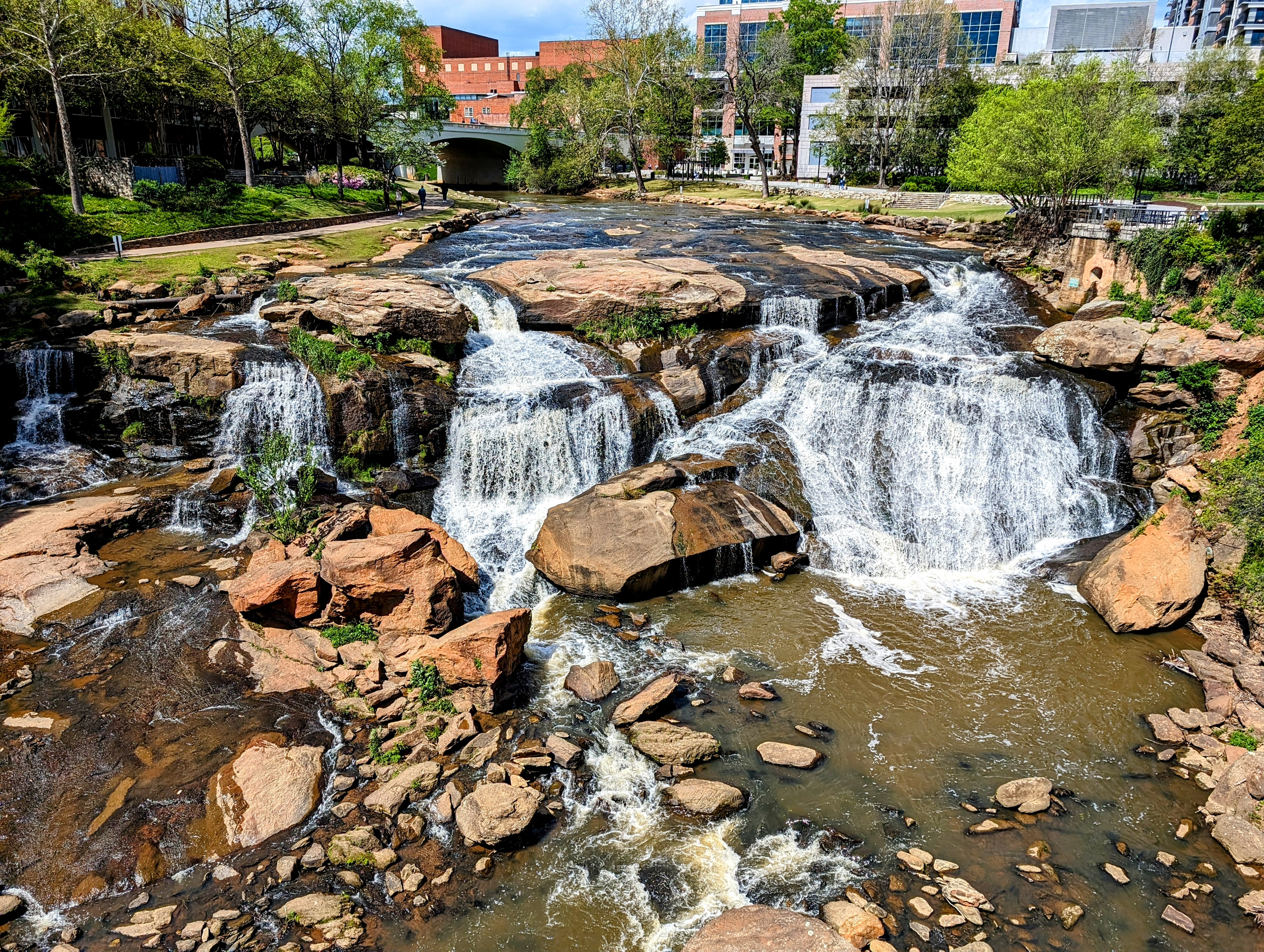
The Camperdown Way bridge was built in 1960, a four-lane highway carrying traffic over the Reedy River Falls - the waterfall that had powered Greenville's original textile mills. The bridge blocked the falls from view; the river was polluted; the area beneath was neglected. In the 1980s, civic leaders began imagining something different: demolish the bridge, restore the falls, create a park. The $9.8 million project seemed extravagant for a struggling textile town. But private donors, led by the Peace family, committed. The bridge came down in 2002; the Liberty Bridge - a curved suspension pedestrian bridge designed to preserve the view - replaced it. Falls Park opened in 2004. The gamble on urban beauty paid off.
Falls Park
Falls Park at the Reedy contains 32 acres of gardens, trails, and the dramatic waterfall that defined Greenville's founding. The Reedy River drops 60 feet over granite boulders in the park's heart; the Liberty Bridge floats above, offering views of the falls and downtown. The park connects to the Swamp Rabbit Trail, a 22-mile greenway that runs from Travelers Rest through Greenville to suburban communities south. Locals jog, families picnic, visitors photograph the falls - the park functions as a genuine urban commons, not a museum piece. The transformation from neglected urban infrastructure to celebrated public space happened in a decade; the before-and-after photographs are astonishing.
Main Street
Main Street runs through downtown Greenville, a 15-block stretch that has become one of America's most successful downtown revivals. The formula was deliberate: wide sidewalks, on-street parking, ground-floor retail, no chains (for years, local restaurants only). The result feels like a main street should - active, walkable, varied. Restaurants ranging from upscale Southern to ethnic to casual pack the blocks; independent shops survive alongside the inevitable gentrification. The Greenville formula - invest in public space, control development quality, prioritize walkability - has been studied and imitated nationwide. What looks effortless required decades of intentional work.
BMW Country
BMW opened its only U.S. manufacturing plant in Spartanburg County, 25 miles east of Greenville, in 1994. The decision was unexpected - South Carolina competed against other states and won, partly on incentives, partly on workforce, partly on proximity to the Port of Charleston. The plant now produces 1,500 vehicles daily, mostly SUVs, making it BMW's largest plant in the world by volume. Michelin's North American headquarters is in Greenville; GE has turbine operations here. The Upstate's economy transformed from textiles to advanced manufacturing without the devastation that similar transitions caused elsewhere. The international presence shows in the restaurants, the multilingual signs, the global character of a small Southern city.
The New South
Greenville-Spartanburg International Airport (GSP) lies between the two cities. The downtown core is walkable; the Swamp Rabbit Trail extends for cycling. The Peace Center for the Performing Arts hosts concerts and theater. The Greenville County Museum of Art contains the world's largest collection of Andrew Wyeth watercolors. Furman University and Bob Jones University represent the city's educational (and ideological) diversity. From altitude, Greenville appears as urban development at the base of the Blue Ridge foothills - Paris Mountain rising behind, the Reedy River winding through, Falls Park visible as a green heart in the downtown. The Southern city that figured out downtown revival, that made a waterfall its symbol.
From the Air
Located at 34.85°N, 82.40°W in the Upstate region of South Carolina at the base of the Blue Ridge foothills. From altitude, Greenville appears as a small city with a distinct downtown core - the Reedy River visible, Paris Mountain rising to the north, development spreading through the Piedmont. GSP airport lies to the east between Greenville and Spartanburg. What appears from the air as an Upstate South Carolina city is the downtown revival success story - where they tore down a highway bridge, built a park around a waterfall, and reinvented a textile town.