Grobina Castle
Vikings knew this place long before the crusaders came. The ancient Curonian hill fort called Skabarzkalns rises just a hundred meters from the stone walls of Grobina Castle, and Scandinavian sources from the 9th century mention this site as Seeburg - the "Sea Fortress." When the Livonian Order built their brick and stone castle here in 1253, they were claiming territory that had connected Baltic traders and Norse raiders for four centuries. The castle's strategic position on the road between Livonia and Prussia made it a prize worth fighting for, and fight they did - Swedes, Poles, Russians, and Germans all left their marks on these walls across seven centuries of conflict and commerce.
Crusaders on the Amber Road
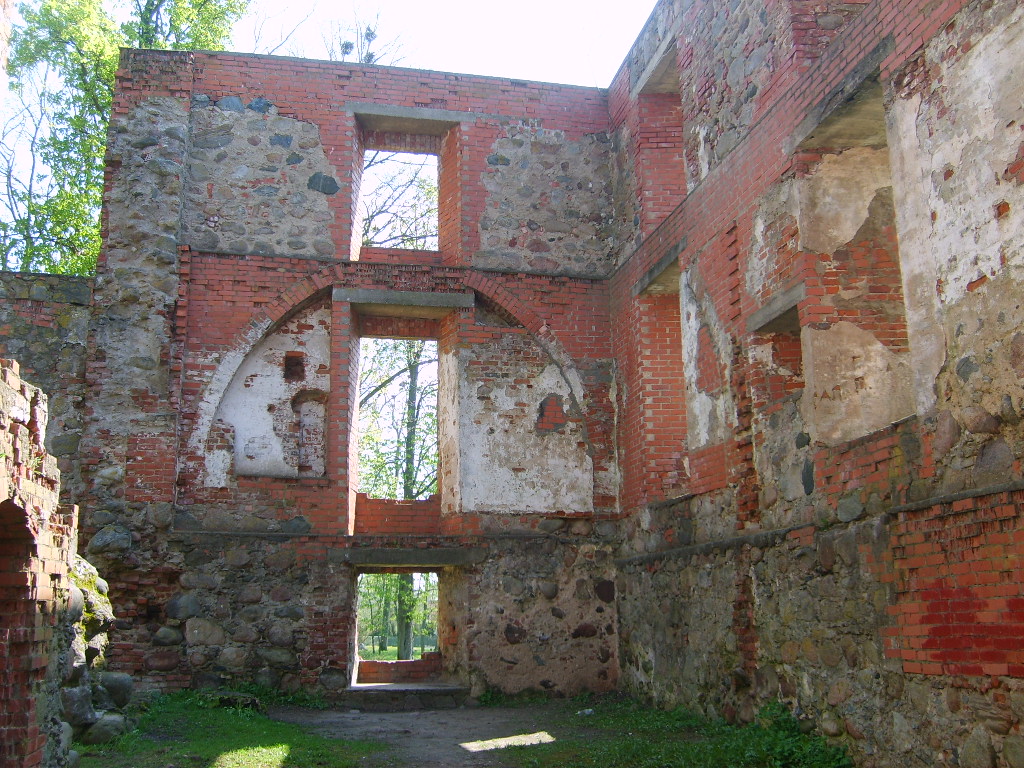
The Livonian Order, that militant arm of medieval Christianity, chose Grobina's location with tactical precision. The castle controlled the ancient Prussian road halfway between Memele and Kuldiga, making it essential to regional commerce and military movement. The original wooden fortification of the 1240s gave way to stone by 1328, when the Teutonic Order took control. Master Gosvin von Herike expanded the fortress around 1347 into the rectangular layout visible today - a three-story residential block in the south wing, a gate tower piercing the western wall, and a soldier's passage running along the second-floor parapets. For nearly two centuries, the Grobina bailiff governed from these chambers, answering only to Kuldiga.
The Duke's Gamble
The 16th century brought transformation through desperation. Gotthard Kettler, the last master of the Livonian Order, pawned Grobina Castle to the Duke of Prussia for 15,000 guilders during the chaos of the Livonian War in 1560. A Protestant pastor was already preaching in the castle chapel when Johan Funks arrived that July, finding an inventory that reads like sacred treasure: silver cups, gilded monstrances, chandeliers large and small. When Wilhelm Kettler married Duchess Sophie of Prussia in 1609, Grobina became a ducal residence. Earthen ramparts with four bastions and palisade fencing rose around the medieval core - the Duchy of Courland was preparing for troubled times.
Wars Without End
Those troubled times arrived with Swedish armies. In 1659, during the Second Northern War, the Swedes burned Grobina town and looted the castle. Then came the Great Northern War and King Charles XII of Sweden, whose forces occupied and wrecked the fortress again. The plague of 1710 delivered a different kind of devastation - most of the remaining population simply died. That same year, Frederick William, Duke of Courland, married Anna Ioannovna on his way through these lands. He died on the return journey; she would become Empress of Russia. The castle's political importance faded with Courland's independence.
From Prison to Park
By 1809, Grobina Castle stood uninhabited and deteriorating. A contemporary observer noted that while the outer walls remained sound, the interior was becoming ruins - though he had found habitable rooms and an old weapons depot just a decade earlier. During Napoleon's invasion of Russia, Prussia's King Friedrich Wilhelm III visited from his refuge in nearby Memel. The 19th century transformed the castle's surroundings into a city park, the romantic ruin becoming a destination rather than a fortress. The walls that once held soldiers now sheltered afternoon strollers.
The Fortress Reborn
Major conservation work in the 1970s, designed by architect I. Stukmanis, stabilized what time and warfare had spared. Today, three stories of medieval walls still stand, hosting concerts and community gatherings where Livonian knights once quartered their troops. The castle and its adjacent hill fort together form an archaeological assemblage that earned a place on Latvia's Tentative World Heritage List in 2017. From Viking trading post to crusader stronghold to ducal residence to romantic ruin to protected monument, Grobina has lived every chapter of Baltic history. The stone and brick that the Livonian Order laid in the 13th century still catches the Courland light.
From the Air
Located at 56.53N, 21.16E near the town of Grobina in western Latvia. The castle ruins and adjacent hill fort are visible from low altitude in the town center, approximately 10 km east of Liepaja. Nearest airport is Liepaja International (EVLA). The Venta River and Baltic coastline provide good visual references for navigation. Best viewed in morning light when the medieval walls cast dramatic shadows.