Grosse Isle
Ships flying blue flags meant fever on board. In the summer of 1847, the flags stretched in a line down the St. Lawrence River, vessel after vessel waiting to reach a small island where doctors were supposed to separate the sick from the healthy. The island was Grosse Isle, Canada's quarantine station, and its chief medical officer, Dr. George Douglas, had already admitted that the regulations were physically impossible to carry out. On June 5 of that year, 25,000 Irish immigrants were either quarantined on the island or waiting aboard ships anchored in the river, trapped between the famine they had fled and the fever that followed them across the Atlantic. By the time the crisis passed, thousands lay buried in mass graves on an island whose name, in bitter irony, simply means 'big island.'
The Coffin Ships Arrive
Grosse Isle opened as a quarantine station in 1832, positioned in the St. Lawrence River about 50 kilometers downstream from Quebec City. For its first fifteen years, it processed immigrants with relative order. Then came the Great Famine. Between 1845 and 1849, blight destroyed Ireland's potato crop and British policy ensured the starving had few options but emigration. They boarded ships so overcrowded and unsanitary they earned the name 'coffin ships.' By mid-summer 1847, the quarantine system had collapsed under the weight of human misery. Doctors examined immigrants by having them walk past, checking the tongues of anyone who looked feverish. Robert Whyte, who published his account as the 1847 Famine Ship Diary, described passengers on the Ajax dressing in their best clothes for inspection, expecting to be processed quickly. Instead, the doctor inspected them briefly and did not return for days. On July 29, Whyte watched a continuous line of boats carrying dead to the burial ground, corpses tied in canvas, their outlines sharp and unmistakable.
Those Who Tried to Help
The staff on Grosse Isle were overwhelmed and undersupplied. Dr. Douglas tried to recruit nurses and doctors from among the healthy passengers, offering high wages, but fear of contagion meant no one volunteered. Prisoners from local jails were released to serve as nurses; many stole from the dead and the dying. All the medical officers on the island became ill at some point. Four doctors died of typhus. Dr. Benson from Dublin, a man experienced in Irish fever hospitals, arrived on May 21 as a passenger, volunteered immediately to help, contracted typhus, and was dead within six days. More than forty priests and clergymen, both Irish-born and French Canadian, ministered to the sick on Grosse Isle, and many fell ill themselves. Bishop Power, the Chief Pastor, contracted fever and died after delivering last rites to a dying woman in September. John Easton Mills, the Mayor of Montreal, also died while caring for the sick. The island consumed its rescuers almost as readily as its refugees.
Beyond the Island
Passing quarantine did not mean safety. The inspections were so perfunctory that many immigrants carrying latent fever were cleared as healthy, only to collapse after leaving Grosse Isle. When Father O'Reilly visited the camp designated for 'healthy' immigrants in August, he administered last rites to fifty people. In the week before August 18, eighty-eight deaths occurred among those the doctors had passed as well. Cities downstream, including Kingston and Toronto, pushed immigrants onward as fast as possible, anxious to avoid contagion in their own streets. Whyte recorded seeing one family sheltering under boards by the roadside and reflected that there was no way to know how many survivors of the ocean crossing and the quarantine were then killed by the severity of a Canadian winter. From its opening in 1832 to its closing in 1937, an estimated 500,000 Irish immigrants passed through Grosse Isle. The station later served against cholera, smallpox, beriberi, and bubonic plague before closing for good.
Anthrax and Animals
Grosse Isle's story did not end with quarantine. During World War II, from approximately 1939 to 1945, the Department of National Defence commandeered the island for biological warfare research, including the manufacture of anthrax. The quiet quarantine station became a weapons laboratory, its isolation now serving a grimmer purpose. After the war, in 1956, Agriculture Canada took over the island to quarantine animals. The buildings that had processed desperate immigrants now held livestock. It was not until 1974 that the Canadian government declared Grosse Isle a National Historic Site, and not until 1993 that it became a national historic park operated by Parks Canada. The long delay in recognition reflected a broader reluctance to confront the island's painful history.
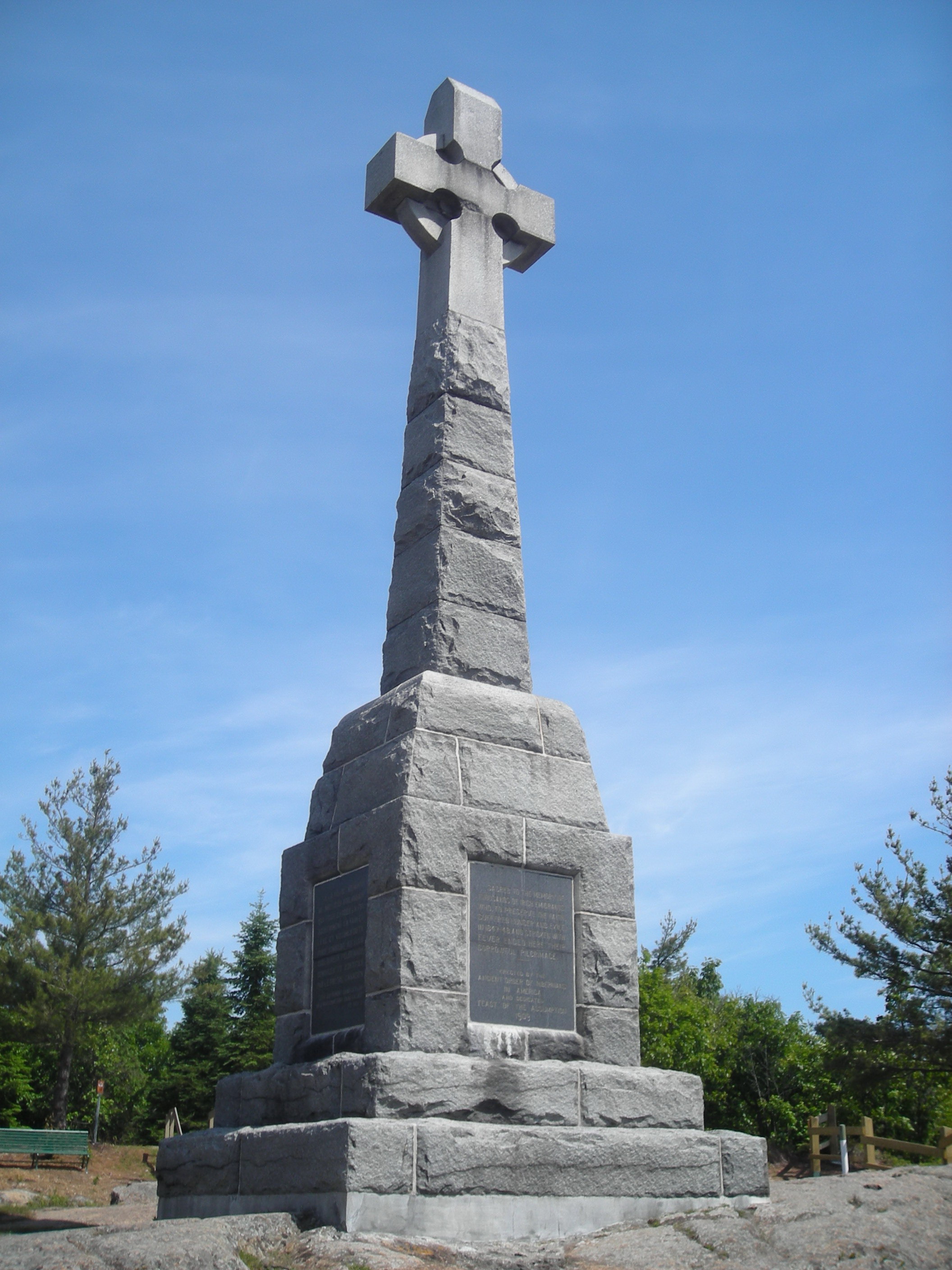
The Celtic Cross and Remembrance
A massive Celtic Cross stands on Grosse Isle, unveiled on August 15, 1909, designed by Jeremiah O'Gallagher of the Ancient Order of Hibernians. It is the largest monument of its kind in North America, with inscriptions in Irish, English, and French. A second memorial was erected in 1997. Today, visitors reach the island by boat and walk the grounds where the disinfection building still contains its original showers and steam apparatus. Costumed interpreters portray the quarantine station's staff. The 1847 lazaretto stands as a monument to desperation. A walking trail leads past the Catholic and Anglican chapels, through the superintendent's gardens, to the Celtic Cross and the Irish Memorial. In 1998, Grosse Isle was twinned with the National Famine Museum in Strokestown, Ireland, connecting the departure point and the arrival point of a tragedy that reshaped two nations. The island is quiet now, the burials settled deep, the river flowing past as it always has, indifferent to the suffering it once carried to these shores.
From the Air
Grosse Isle is located at 47.033N, 70.667W in the St. Lawrence River, approximately 50 km downstream (northeast) from Quebec City. The island is part of the 21-island Isle-aux-Grues archipelago, visible as a cluster of small islands in the wide stretch of the St. Lawrence. From altitude, look for the chain of islands on the south side of the river between Quebec City and Riviere-du-Loup. The island itself is small and low-lying, best identified by its position within the archipelago. Quebec City Jean Lesage International Airport (CYQB) is the nearest major airport, about 50 km to the southwest. The much larger Ile d'Orleans is visible upstream and serves as a landmark for orientation. The St. Lawrence is very wide at this point, nearly 20 km across, with both shores visible. Best viewed at 3,000-5,000 ft where the island shapes and river channels become distinct. The Celtic Cross memorial on the island is not visible from typical flight altitudes.