Grossglockner High Alpine Road
In 1924, when a group of Austrian experts proposed building a road over the Hochtor pass, they were laughed at. Austria, Germany, and Italy had a combined total of 154,000 private automobiles. The country had shrunk to a seventh of its imperial size after the First World War, lost its international markets, and was bleeding from devastating inflation. Even a 3-meter gravel track with occasional overtaking points seemed extravagant. Then came the Wall Street crash of 1929. Unemployment hit 26 percent, and the government -- desperate to put people to work -- revived the Grossglockner project. On August 30, 1930, at 9:30 in the morning, the first explosives detonated at Ferleiten. The road that nobody wanted had become the road that 3,200 jobless workers would build.
Carving a Road Through the Alps
The Grossglockner High Alpine Road connects Bruck in the Salzach Valley of Salzburg province with Heiligenblut in Carinthia, crossing the Alpine divide through a tunnel at Hochtor Pass at 2,504 meters. Numbered hairpin curves wind upward from the northern toll booth at Ferleiten, with a 1.5-kilometer spur climbing to the Edelweisspitze viewpoint at 2,571 meters -- the road's highest point and one of the loftiest you can drive to in Austria. Franz Rehrl, the Salzburg provincial governor, and engineer Franz Wallack championed the project against relentless skepticism. Planners designed for 120,000 annual visitors, a figure critics mocked as fantasy. Four years after construction began, Rehrl and Wallack climbed into a Steyr 100 automobile and completed the first crossing of the Alpine divide on a graded road.
The Skeptics Were Wrong
The Grossglockner High Alpine Road opened on August 3, 1935, inaugurated the following day with an international automobile and motorcycle race. The total cost, including access roads, came in at 910 million Austrian Schillings at 1990 rates -- seven million less than estimated. By 1938, the road that critics said would never attract enough traffic was drawing 375,000 visitors in 98,000 vehicles, more than triple the projected figure. After the disruption of the Second World War, it took until 1952 to surpass that prewar record, with 412,000 visitors. By 1962, 1.3 million people were making the crossing. The motorcycle -- once the poor man's car -- accounted for a quarter of early traffic. Its share collapsed to just 2,071 bikes in 1968 as automobiles became affordable, then resurged to over 76,000 by 2003 as riding became a lifestyle choice.
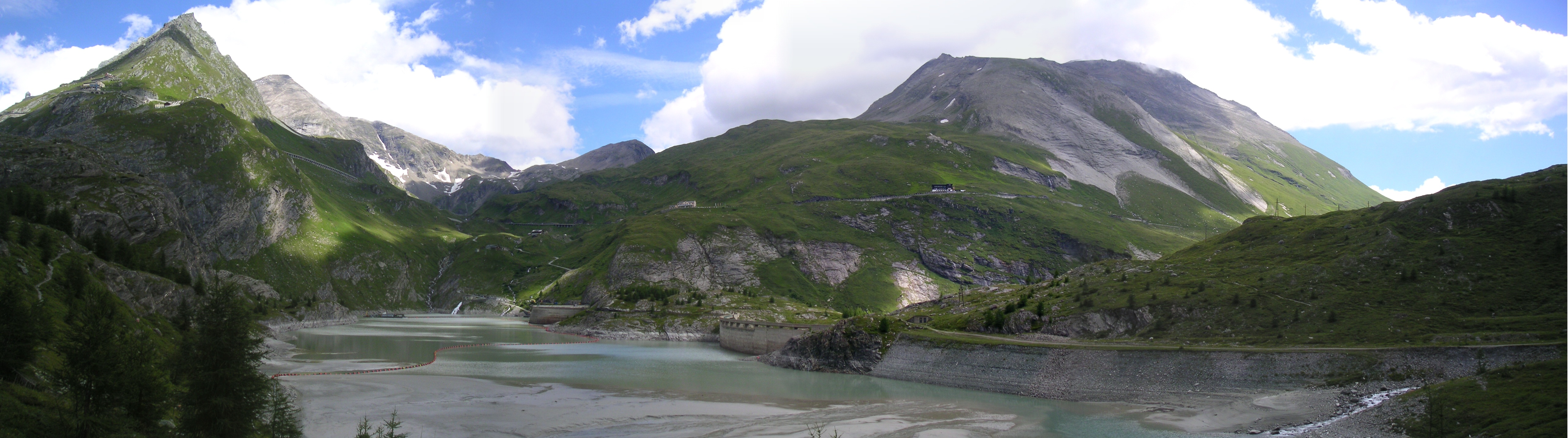
Six Hundred Thousand Tons of Snow
The road is normally open from May to October, and the annual reopening is an engineering feat in itself. In the 1930s, 350 workers shoveled 250,000 cubic meters of snow over 70 days to clear a single lane. Since 1953, five Wallack rotary plows and twelve workers from GROHAG, the road's operating company, have been clearing 600,000 tons of snow from the road and parking areas in roughly fourteen days each April. The contrast is stark: in 1937, the road was passable for only 132 days a year. By 1963, modern clearing equipment had extended the season to 276 days. Increasing traffic demanded modernization after 1953 -- the road was widened to 7.5 meters, hairpin radii expanded from 10 to 15 meters, and parking capacity grew from 800 to 4,000 spaces.
The Emperor's View
A spur road branches south from the main route to the Kaiser-Franz-Josefs-Hohe visitors' center at 2,369 meters, named for the visit of Emperor Franz Joseph I and Empress Elisabeth in 1856. The overlook offers a panoramic view of the Pasterze Glacier, the Grossglockner massif -- Austria's highest mountain at 3,798 meters -- the Glocknerwand, and the Johannisberg. It is, by any measure, one of the most dramatic roadside viewpoints in Europe. The Giro d'Italia has climbed the Grossglockner twice: in 1971, when it became the first and still only Cima Coppi -- the race's highest point -- located outside Italy, and again in 2011. The opening of the Felbertauern Road in 1967 and the Tauern Motorway in 1975 drew through-traffic away, but they also completed the road's transformation from the only transalpine crossing between the Brenner and Katschberg passes into what it was always meant to be: a scenic road, driven for the sheer experience of the drive.
From the Air
Located at 47.083N, 12.842E, the Grossglockner High Alpine Road is a dramatically visible ribbon of switchbacks crossing the main Alpine divide in the Hohe Tauern range of central Austria. The Grossglockner summit (3,798 m / 12,461 ft) is the dominant peak to the south-southwest. The Pasterze Glacier is visible below the Kaiser-Franz-Josefs-Hohe viewpoint. Best viewed from 8,000-10,000 feet AGL approaching from the north, where the numbered hairpin curves and the road's trajectory across the ridge are clearly visible. Nearest airports: Salzburg (LOWS) approximately 50 nm to the north, Innsbruck (LOWI) approximately 80 nm to the west. Terrain is extremely mountainous; maintain safe altitude.