Guadalupe Mountains National Park
The Guadalupe Mountains erupt from the West Texas desert like a geological time machine. Guadalupe Peak, at 8,751 feet the highest point in Texas, is the exposed edge of the Capitan Reef - a massive limestone formation built by sponges, algae, and microorganisms when this land lay beneath a Permian sea 260 to 270 million years ago. The same reef system extends underground to form the spectacular chambers of Carlsbad Caverns twenty miles to the north. Above ground, the Guadalupes compress three distinct ecosystems into a single park: Chihuahuan Desert salt flats, forested canyons with maples and oaks fed by hidden springs, and alpine highlands where Douglas firs and aspens grow at elevations more typical of Colorado than Texas.
An Ancient Reef in the Sky
The Guadalupe Mountains give their name to the Guadalupian epoch of the Permian period - this is the type locality, the place where geologists defined that slice of deep time. Two hundred sixty million years ago, a shallow tropical sea covered this region, its coastline marked by a horseshoe-shaped reef teeming with marine life. Unlike modern coral reefs, the Permian reef was built primarily by calcareous sponges, bryozoans, and cyanobacteria. When the sea eventually evaporated, the reef was buried under thousands of feet of sediment. Tectonic forces during the Cenozoic era uplifted the ancient seabed, and erosion stripped away the overlying layers to expose the reef's spectacular profile. El Capitan, the sheer limestone cliff that served as a landmark for travelers on the Butterfield Overland Mail route, is the reef's most dramatic face - a thousand-foot wall of fossilized sea creatures visible for fifty miles across the desert.
The Mescalero Apache Homeland
For thousands of years, the Guadalupe Mountains provided resources for the people who lived in and around them. Archaeological evidence shows human presence dating back more than 10,000 years, with projectile points, baskets, pottery, and rock art found in the mountains' many caves and alcoves. The Mescalero Apache made the range their homeland, following game through the highlands and harvesting agave - the mescal plant that gave them their Spanish name, meaning "mescal-makers." Agave roasting pits, where the plant's hearts were slow-cooked for days to produce a sweet, nutritious food, still dot the landscape. The Apache connection to the mountains ended violently in 1869, when Lieutenant H.B. Cushing led the 9th Cavalry Regiment into the range and destroyed two Mescalero camps. The survivors were forced onto reservations, clearing the way for Anglo ranchers who would shape the next chapter of the mountains' human story.
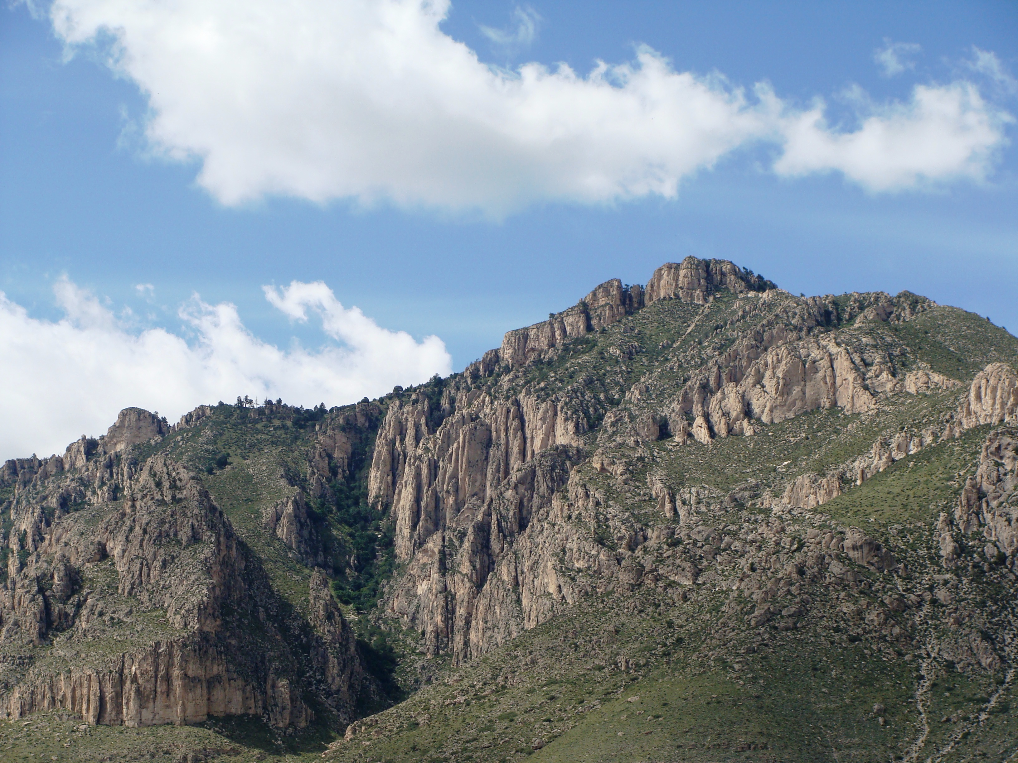
McKittrick Canyon's Hidden Forest
If the Guadalupe Mountains surprise visitors with their sudden rise from the desert, McKittrick Canyon delivers an even greater shock: a riparian forest of bigtooth maples, Texas madrones, velvet ash, and chinkapin oaks thriving in what appears to be an impossibly arid landscape. The canyon's secret is its springs, fed by water that fell as rain on the highlands and percolated through the porous limestone for decades before emerging in the canyon bottom. In autumn, the maples turn brilliant crimson and gold - one of the few fall color displays in Texas. The canyon is considered so ecologically sensitive that the National Park Service restricts access to daytime hours only; no camping or backcountry permits are issued for McKittrick. The fragile ecosystem represents a relict forest, a remnant of cooler, wetter times when such woodlands stretched across what is now desert.
Ranchers and Ruins
Anglo settlement in the Guadalupes began in the 1870s with Felix McKittrick, a cattleman who worked the range and likely gave McKittrick Canyon its name. The Rader brothers built Frijole Ranch in 1876, the first permanent structure in the region. For decades it served as the community's center - ranch house, post office, and social gathering place for the isolated families who ran cattle in these remote mountains. Judge J.C. Hunter of Van Horn eventually consolidated the smaller operations into the Guadalupe Mountain Ranch. The 1908 Williams Ranch, accessible today only by a rough four-wheel-drive road, still stands as a monument to the determination required to wrest a living from this beautiful but unforgiving landscape. The ruins of Pinery Station, a stop on the Butterfield Overland Mail route constructed in 1858, lie near the Pine Springs visitor center - a reminder that people have been passing through Guadalupe Pass for generations, whether on foot, by stagecoach, or by car.
Sky Islands and Desert Seas
The Guadalupe Mountains function as a biological sky island - an isolated highland ecosystem surrounded by desert lowlands, where species adapted to cooler, wetter conditions survive as relicts from the last ice age. Over 1,000 plant species have been documented in the park, including the Guadalupe Mountains violet, found nowhere else on Earth. The wildlife is equally diverse: elk, mule deer, mountain lions, and black bears roam the highlands; javelinas and sixteen species of bats inhabit lower elevations; golden eagles and peregrine falcons hunt the cliffs. The park was established in 1972, the culmination of decades of effort to protect these mountains from development. Two-thirds of its 86,367 acres are now designated wilderness. For visitors willing to hike the steep trails to the summit of Guadalupe Peak or explore the hidden canyons, the reward is a landscape that spans deep time - from a Permian reef to an ice-age forest to a Chihuahuan Desert that continues to evolve today.
From the Air
Located at 31.92°N, 104.87°W in far West Texas, about 110 miles east of El Paso. The Guadalupe Mountains rise dramatically from the desert floor, with El Capitan's sheer limestone face visible from great distances to the south and west. Guadalupe Peak (8,751 feet MSL) is the highest point in Texas. The range trends north-northeast toward Carlsbad Caverns National Park, which sits on the same Capitan Reef formation. Nearest airports: Carlsbad-Cavern City Air Terminal (KCNM) approximately 55 miles northeast, Dell City Municipal (E03) approximately 30 miles southwest. Elevation at Pine Springs Visitor Center: 5,840 feet. Mountain weather can be unpredictable; high winds are common, particularly in winter and spring. No improved landing facilities within the park.