Guallatiri
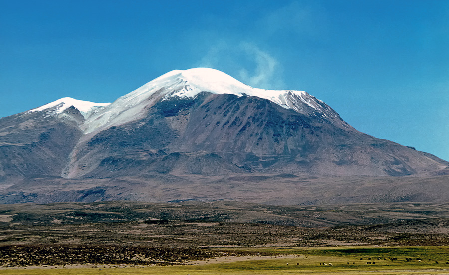
The plume gives Guallatiri away long before you can see the mountain itself. Visible from more than 125 miles, the fumarole cloud rising from the summit of this 6,060-meter stratovolcano in Chile's Arica y Parinacota Region is so persistent that mountaineers in 1966 reported fire emanating from the vents. The Chipaya people of the Altiplano believed the waters of the Lauca River flowed directly from hell through the volcano. The Aymara, who live closer, took a gentler view: they considered Guallatiri a family of three protective mountain spirits and built their village church to point directly at the peak.
Named for the Flamingos
The word Guallatiri comes from the Aymara wallatiri, a reference to the flamingos that inhabit the wetlands around the volcano's base. Three species share the territory: the Andean flamingo, the Chilean flamingo, and the rare James's flamingo. They are not alone. Condors ride the thermals above the summit glaciers. Vicunas graze on the lower slopes alongside llamas and alpacas. The volcano sits inside Lauca National Park, where the tundra climate supports woodlands of Polylepis tarapacana, a tree that forms the highest forests on Earth. Below the tree line, the wetlands at the volcano's base have regional ecological importance, fed by streams that run off Guallatiri's glaciers and hot springs. At Chiriguaya, on the northwestern foot of the mountain, bubbling pools reach 48 degrees Celsius, depositing sinter where groundwater meets the magmatic system.
Fire and Ice in Collision
Above 5,500 meters, Guallatiri wears an ice cap that has been shrinking and fragmenting throughout the twentieth and twenty-first centuries. By recent measurement, the cap covered just 0.796 square kilometers, retreating at a rate of 0.07 square kilometers per year. The fumaroles themselves may be accelerating the melt: a 2005 study found that heat from the vents contributes to enhanced ice loss. It is a striking contradiction. The volcano breathes sulfurous gas from two main fumarole fields, one just below the summit on the western flank and another on the south-southwestern slopes. Individual vents build cones up to 6 meters wide and 3 meters high. Liquid sulfur flows in pahoehoe-like ribbons up to 15 meters long. The deposits paint the upper mountain in yellow, orange, and red, while the fumarole gases carry hydrogen sulfide, sulfur dioxide, and traces of mercury and arsenic into the thin Andean air.
Centuries of Restless Earth
Guallatiri is the second-most active volcano in northern Chile, behind only Lascar. Volcanic activity here began somewhere between 710,000 and 130,000 years ago, building the mountain through two major growth phases. The largest Holocene eruption, roughly 2,600 years ago, was a Plinian or sub-Plinian event that deposited tephra over 1.3 meters thick at a distance of 12 kilometers. Documented historical eruptions occurred in 1825, 1913, 1959, and 1960, all rated at a volcanic explosivity index of 2. Additional poorly documented eruptions are reported from 1862, 1864, 1870, 1902, 1904, and 1987. In May 2015, SERNAGEOMIN raised the alert level when seismic activity increased and a 200-meter plume appeared, lowering it again in July when the volcano quieted. The mountain remains restless. Shallow earthquakes and sporadic seismic swarms are recorded regularly. Guallatiri ranks as the 30th most dangerous volcano in Chile.
A Family on the Horizon
The Aymara community of Guallatire did not see a single mountain. They saw a household. The eastern peak they called Maria Qapurata, the wife. The western peak was Pedro Qapurata, the husband. Between them stood Elena Qapurata, the daughter. Every January 1, the community celebrated rituals at the foothills. The church in the village of Guallatiri, 9.5 kilometers southwest of the volcano, was built so that its entrance faces the peak. The Chipaya people held a darker interpretation. In their oral tradition, cold winds called soqo blow from the Pacific across the Altiplano toward Guallatiri, and the volcano is linked with Hell itself. Whether protective family or infernal gateway, Guallatiri occupies a place in the Andean imagination that its remoteness has done nothing to diminish. The volcano sits near the Bolivia-Chile frontier, far from any major city, monitored since 2013 by the Southern Andean Volcano Observatory via video, seismic sensors, and deformation measurements.
From the Air
Located at 18.42°S, 69.09°W in the Arica y Parinacota Region of far northern Chile, near the Bolivia border. The volcano rises to 6,060 meters (19,882 feet) above sea level on the western edge of the Altiplano, with the surrounding terrain at roughly 4,300 meters. The persistent fumarole plume is visible from well over 100 miles in clear conditions, making it a prominent visual landmark. Lake Chungara lies to the north. Nearest significant airport is Chacalluta International (SCAR/ARI) in Arica, approximately 130 km to the west. Extreme altitude requires awareness of terrain and mountain-wave turbulence. The area falls within Lauca National Park.