Guantanamo Bay
Fidel Castro kept the rent checks in a desk drawer. Every year after the Cuban Revolution, the United States sent a payment of $4,085 for its lease on Guantanamo Bay - a figure that began as $2,000 in gold coins in 1903, was converted to $3,386.25 in dollars in 1934, and adjusted upward to $4,085 in 1974 as gold prices rose. Castro cashed one, early on, which he later attributed to "confusion." The rest he stuffed into a drawer, made out to the "Treasurer General of the Republic," a title his revolution had abolished. It was a small, stubborn protest against a lease Cuba never wanted and could not break. The bay itself - the largest natural harbor on Cuba's south coast, ringed by steep hills that seal it off from the island's interior - has watched this argument for more than a century with the indifference that geography shows to politics. Empires come and go. The harbor remains.
Puerto Grande, Cumberland Bay, Guantanamo
The bay has been renamed by nearly everyone who found it. The Taino people, the island's original inhabitants, called it Guantanamo - a name that survived conquest, colonization, and revolution. Christopher Columbus landed in 1494 and called it Puerto Grande. His crew found Taino fishermen preparing a feast for a local chieftain, a scene of domestic normalcy that would not survive the century. When Spain took control of Cuba, the bay became a vital harbor on the island's south side, its deep water and sheltered position making it a natural anchorage.
In 1741, during the War of Jenkins' Ear, British Admiral Edward Vernon arrived with eight warships and 4,000 soldiers, renamed the bay "Cumberland Bay," and laid plans to march on Santiago de Cuba. Local Spanish colonial troops defeated him and forced a withdrawal. The British name vanished with the British fleet. The Taino name endured, as indigenous names often do when they fit the land better than anything conquerors can invent.
The Lease That Cannot Die
The United States first seized the bay during the Spanish-American War in 1898. Five years later, Tomas Estrada Palma, Cuba's first president, signed a perpetual lease under the terms of the Platt Amendment - legislation that the U.S. Congress had required Cuba to incorporate into its own constitution as a condition of independence. The 1903 Cuban-American Treaty of Relations granted the United States "complete jurisdiction and control" over Guantanamo Bay while acknowledging that Cuba retained "ultimate sovereignty." It was a legal construction designed to give America a base without giving Cuba a choice.
In 1934, a new treaty modified the terms: the annual payment shifted from gold coins to dollars, Cuba's trading partners gained free passage through the bay, and the lease became permanent unless both governments agreed to end it - or the United States simply walked away. Neither has happened. After Castro's revolution, President Eisenhower insisted the base remain. The Cuban government has protested ever since. Legal scholars have argued the lease was imposed under duress, a treaty between unequals incompatible with modern international law. The base covers 116 square kilometers on both banks of the bay, and it has operated continuously since 1898, making it the oldest overseas U.S. naval installation.
Refugees and Razor Wire
Before Guantanamo Bay became synonymous with the War on Terror, it served as a processing center for people fleeing violence across the Caribbean. In the 1990s, the United States intercepted tens of thousands of Haitian and Cuban refugees at sea and brought them to the base. Over six months, more than 30,000 Haitians were interned at Guantanamo while another 30,000 fled to the Dominican Republic. The U.S. eventually granted refugee status to 10,747 of them. Most were housed in a tent city on a repurposed airstrip - the same site that would later hold the military commissions complex.
Refugees who presented discipline or security concerns were held at a site that would later become Camp X-Ray, the initial facility of the Guantanamo Bay detention camp. In August 1994, rioting broke out in the refugee camps. Twenty U.S. military police and forty-five Haitians were injured. The episode revealed a pattern that would repeat: Guantanamo's geographic isolation and legal ambiguity made it useful for holding people the government wanted to keep at arm's length - close enough to control, far enough to argue that normal rules did not apply.
The Bay Between Nations
From the air, Guantanamo Bay looks like what it is: a deep horseshoe of water biting into Cuba's southeastern coast, enclosed by hills so steep they form a natural fortress. The climate is hot and semi-arid, one of the driest corners of an otherwise lush island. The naval base, nicknamed "Gitmo," sprawls across both the eastern and western shores, connected by ferry across the water since the road through Cuban territory has been closed for decades.
The bay occupies a strange position in international relations - a piece of one country operated by another under a contract that one party considers void and the other considers permanent. Cuba has not accepted a lease payment since the early 1960s. The United States has not left since 1898. Since 2002, the base has housed detention facilities for individuals deemed risks to national security, a function that has drawn more global attention than a century of naval operations ever did. President Obama ordered the detention camp closed by January 2010; Congress blocked the funding. The detention facilities remain. The lease remains. The bay itself, indifferent to treaties and tribunals, remains what the Taino named it - Guantanamo, a harbor shaped by geology, defined by history, and claimed by everyone.
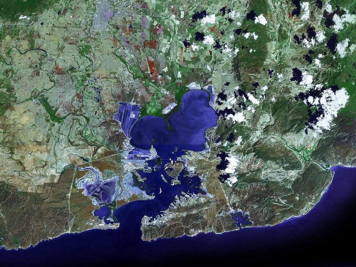
From the Air
Located at 19.93N, 75.15W at the southeastern tip of Cuba. Guantanamo Bay is the largest natural harbor on Cuba's south coast, clearly visible from altitude as a horseshoe-shaped inlet surrounded by steep, arid hills. The U.S. Naval Base (ICAO: MUGM, Leeward Point Field) has a 2,400m runway on the western shore. The base covers 116 sq km across both sides of the bay, connected by ferry since the overland route through Cuban territory is closed. From 5,000 ft, the full layout is striking - the narrow channel from the Caribbean opens into a broad inner harbor. Caimanera, a Cuban town on the inner bay's western shore, sits just kilometers from the U.S. perimeter. The surrounding terrain is notably dry compared to the rest of Cuba - semi-arid hills with sparse vegetation. Santiago de Cuba (ICAO: MUCU) is approximately 65 km to the west. The Windward Passage between Cuba and Haiti is visible to the east. Typically clear flying conditions with warm temperatures year-round.