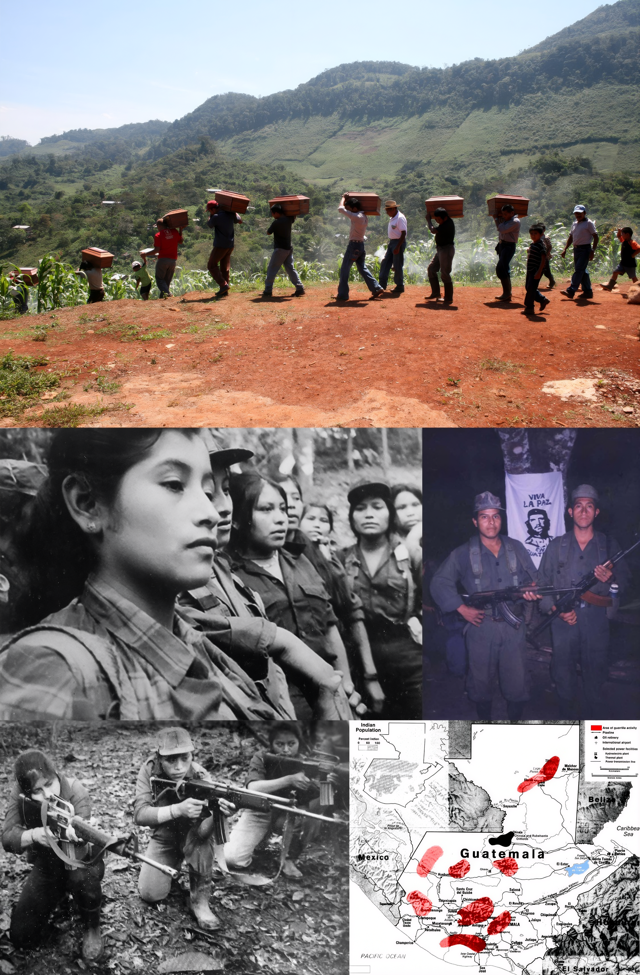
Guatemalan Civil War
The names take hours to read. Inscribed on memorials across Guatemala, they belong to the estimated 200,000 people killed or forcibly disappeared during a civil war that lasted 36 years, from 1960 to 1996. Of those the United Nations-sponsored Historical Clarification Commission was able to identify, 83 percent were indigenous Maya. This was not collateral damage. The Guatemalan military systematically destroyed 440 Maya villages between 1981 and 1983 alone, carried out 626 documented massacres, and waged what the commission concluded was genocide. The war began as a Cold War proxy conflict over land reform and political power. It ended as something far darker — a campaign to erase entire communities from the highlands where they had lived for centuries.
Seeds Planted in a Coup
The roots reach back to 1954, when a CIA-backed coup overthrew the democratically elected government of Jacobo Arbenz, whose land reforms had threatened the holdings of the United Fruit Company and alarmed Washington during the early Cold War. The military governments that followed dismantled those reforms and consolidated power. On November 13, 1960, a group of left-wing junior military officers, outraged by corruption and the government's role in allowing CIA training camps for the Bay of Pigs invasion on Guatemalan soil, launched a failed revolt against President Miguel Ydigoras Fuentes. The officers who survived went into hiding and formed the nucleus of what would become several guerrilla movements. Guatemala's civil war had begun — not as a popular uprising, but as a fracture within the military itself.
A Cemetery to Pacify
Through the 1960s and 1970s, successive military rulers escalated repression far beyond any proportional response to the guerrilla threat. Colonel Carlos Arana Osorio, who assumed the presidency in 1970, declared a state of siege that November, imposing curfews under which even ambulances were forbidden to move. Government sources acknowledged 700 executions by security forces in the first two months. Death squads with names like Mano Blanca and Ojo por Ojo operated under government protection, abducting, torturing, and killing students, labor organizers, and anyone suspected of leftist sympathies. Arana himself stated plainly: "If it is necessary to turn the country into a cemetery in order to pacify it, I will not hesitate to do so." Between 1966 and 1973 alone, as many as 42,000 Guatemalan civilians were killed or disappeared. The majority of victims during this period were residents of Guatemala City — not guerrilla fighters, but ordinary people caught in a widening net of state terror.
The Burning Highlands
The worst came in the early 1980s. After General Efrain Rios Montt seized power in a March 1982 coup, the military launched its "scorched earth" campaign in the Maya highlands. Entire villages were surrounded and destroyed. The army did not distinguish between combatants and civilians — children, elders, and families who had no connection to the guerrillas were massacred alongside anyone suspected of supporting them. Rios Montt established secret tribunals that operated outside the judiciary, executing prisoners within weeks of capture. In the seventeen months of his rule, an estimated 70,000 people were killed or disappeared. The Indigenous Ixil Maya communities in the highlands of Quiche were targeted with particular ferocity. Survivors who fled into the mountains faced starvation and exposure. Those who remained lived under military control in "model villages" designed to sever their connections to their communities, their land, and their identity.
Thirty-Six Years to Peace
The killing diminished but did not stop after Rios Montt was himself overthrown in an August 1983 coup. A civilian government took office in 1986 under a new constitution, and a slow, painful peace process began. It took another decade. The final peace accord was signed on December 29, 1996, brokered by the United Nations. The Historical Clarification Commission, which published its findings in 1999, attributed 93 percent of all human rights violations during the war to state forces and related paramilitary groups. The guerrillas were responsible for three percent. The commission's conclusion was unambiguous: the Guatemalan state committed acts of genocide against the Maya people. In 2013, Rios Montt was tried on charges of genocide for the killing and disappearance of more than 1,700 Ixil Maya during his rule — the first time a former head of state had been tried for genocide by a court in his own country.
What Remains
Guatemala City today is a place where the war's geography is still legible if you know where to look. The National Palace, where Rios Montt's secret tribunals operated, is now a museum. The Spanish Embassy site, where 37 people were burned alive in 1980 when security forces stormed the building during a peaceful occupation by indigenous activists, is marked by a memorial. At the Metropolitan Cathedral, twelve pillars bear the names of the disappeared. The war shaped everything that followed — the migration patterns, the poverty, the distrust of institutions, the fractured relationship between the state and its indigenous majority. More than 200,000 people died. More than a million were displaced. What those numbers represent is not a statistic but an accumulation of individual lives — parents, children, farmers, teachers, students — each taken from a family that still carries the absence.
From the Air
Guatemala City sits at 14.633°N, 90.500°W in a highland valley at approximately 4,900 feet elevation. La Aurora International Airport (MGGT) is the primary field, located about 4 km south of the city center. From 4,000-6,000 feet AGL, the dense urban grid of Guatemala City is visible filling the valley, with the volcanic peaks of Agua, Fuego, and Acatenango visible to the west and southwest. The highlands of Quiche department, where the worst massacres occurred, lie roughly 100 km to the northwest. Expect afternoon convective activity and occasional reduced visibility from volcanic haze.