Guayabo National Monument
Nobody knows why they left. Sometime around 1400 CE, roughly 10,000 people abandoned a thriving city on the southern slope of Turrialba Volcano and walked into history without explanation. A century later, the Spanish arrived in Costa Rica and found no one living at Guayabo de Turrialba. The jungle moved in, burying stone foundations, aqueducts, and roadways under centuries of growth. Today, only a small fraction of the 2.3-square-kilometer site has been excavated, and the mystery of its abandonment remains unsolved. Disease, warfare with rival civilizations, internal collapse - researchers have speculated about all of these and confirmed none. What they have confirmed is that the people who built Guayabo were remarkable engineers, and the American Society of Civil Engineers agreed: in 2009, the organization declared Guayabo an International Historic Civil Engineering Landmark.
Engineers of the Cloud Forest
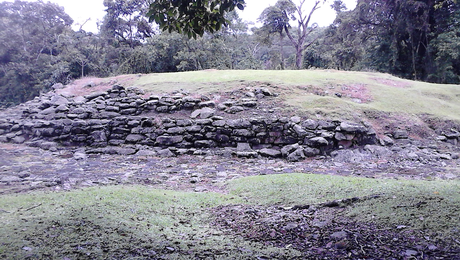
The excavated portion of Guayabo reveals a city that was planned, not improvised. Forty-three stone foundations mark where conical wooden structures once stood - large communal houses with thatched roofs where extended families lived together. Three aqueducts channeled water through the settlement, a feat of hydraulic engineering that still impresses modern visitors. Two major roadways connected Guayabo to surrounding settlements, with one extending at least nine kilometers into the countryside, flanked by dozens of smaller paths. The centerpiece is Mound 1, the largest foundation of its kind in this culture, positioned at the heart of the village with a paved road running before it. Archaeologists believe this structure served as both a civic center and a symbol of authority. Stone tombs and petroglyphs are scattered throughout the site, their carved symbols still legible after centuries of tropical rain.
From the Jungle to the World's Fair
The site was first discovered in the 1800s and initially excavated in 1882. Nine years later, a cemetery excavation yielded over 100 artifacts that traveled far from the Costa Rican jungle. They were displayed at the 1892 Historical American Exposition in Madrid, then shipped across the Atlantic for the 1893 World's Columbian Exposition in Chicago. Explorers and archaeologists who worked the site over the decades - Anastacio Alfaro, Carlos Aguilar, Oscar Fonseca, Sergio Chavez - gradually revealed the scale of what lay beneath the forest floor. Further excavations in the 1960s uncovered the infrastructure that convinced scholars this was no small village but a regional center of power. Guayabo was populated beginning around 1000 BCE, meaning the settlement endured for roughly 2,400 years before its mysterious abandonment.
The Unexcavated Majority
What visitors see today is believed to be the central portion of the site - and even that represents only a fraction of the whole. The vast majority of Guayabo remains underground, untouched by excavation. Recent studies have used remote sensing techniques to detect and map buried roads and structures extending well beyond the visible ruins. As of 2020, no LIDAR surveys had been conducted, leaving open the possibility that the true extent of the settlement is far larger than current maps suggest. This is part of what draws visitors: unlike Machu Picchu or Chichen Itza, where decades of excavation have revealed largely complete sites, Guayabo feels unfinished. You walk the trails knowing that beneath the rainforest floor, just meters from the path, entire neighborhoods may lie waiting.
Rainforest Guardian
The monument has been open to the public since August 13, 1973, and its relative obscurity has been a form of protection. Where Machu Picchu receives over half a million visitors annually, Guayabo sees far fewer, making preservation easier and the experience more intimate. The site sits within the Central Volcanic Conservation Area, surrounded by rainforest so dense and green that the stone ruins seem to emerge from the earth like geological features rather than human constructions. Costa Ricans who live near the monument take its preservation seriously - not just for tourism revenue, but because the site connects them to a past that predates colonial history by millennia. Hiking trails loop through the grounds, and professional guides can contextualize what the stones and petroglyphs mean. The vibrant green canopy, fed by heavy precipitation and volcanic soils, makes Guayabo feel less like a museum and more like a living landscape that happens to contain an ancient city.
From the Air
Located at 9.97N, 83.69W on the southern slope of Turrialba Volcano in Cartago Province, Costa Rica. The 2.3 km2 monument is embedded in dense rainforest and difficult to distinguish from the air without knowing the exact coordinates. Juan Santamaria International Airport (MROC/SJO) is approximately 65km to the west. Turrialba Volcano's active summit is visible to the north. The site sits at moderate elevation in the transition zone between the Central Valley agricultural lands and the Caribbean slope jungle. Look for the cleared archaeological area as a lighter patch within the surrounding dense forest canopy.