Gulf of Fonseca
The Gulf of Fonseca is named after a man who never saw it -- Archbishop Juan Rodriguez de Fonseca, a Spanish prelate best remembered as the implacable enemy of Christopher Columbus. When the explorer Gil Gonzalez de Avila sailed into this Pacific inlet in 1522, he named it for his patron back in Spain, not realizing he was christening one of Central America's most contested bodies of water. Five centuries later, three nations -- El Salvador, Honduras, and Nicaragua -- still share its 3,200 square kilometers of warm, shallow sea, and the arguments over who owns what have filled courtrooms from the Central American Court of Justice to the International Court of Justice in The Hague.
Where Three Flags Touch the Water
The coastline of the Gulf extends for 261 kilometers, but the distribution is anything but equal. Honduras claims 185 kilometers of shore. Nicaragua holds 40. El Salvador gets 29. The disparity has fueled territorial friction since independence, compounded by the volcanic islands scattered across the Gulf's interior. In 1992, the International Court of Justice attempted to settle the matter, awarding El Salvador the islands of Meanguera and Meanguerita while Honduras received El Tigre Island. All three countries were ordered to share control of the Gulf itself. The ruling brought legal clarity, if not complete peace. The islands remain sensitive territory -- El Tigre, sitting at the Gulf's entrance, has been fought over since the 1840s, when a British naval commander seized it to block an American canal project and was humiliated when the American diplomat E. G. Squier revealed he had already negotiated its cession to the United States.
Mangroves and the Rhythm of Tides
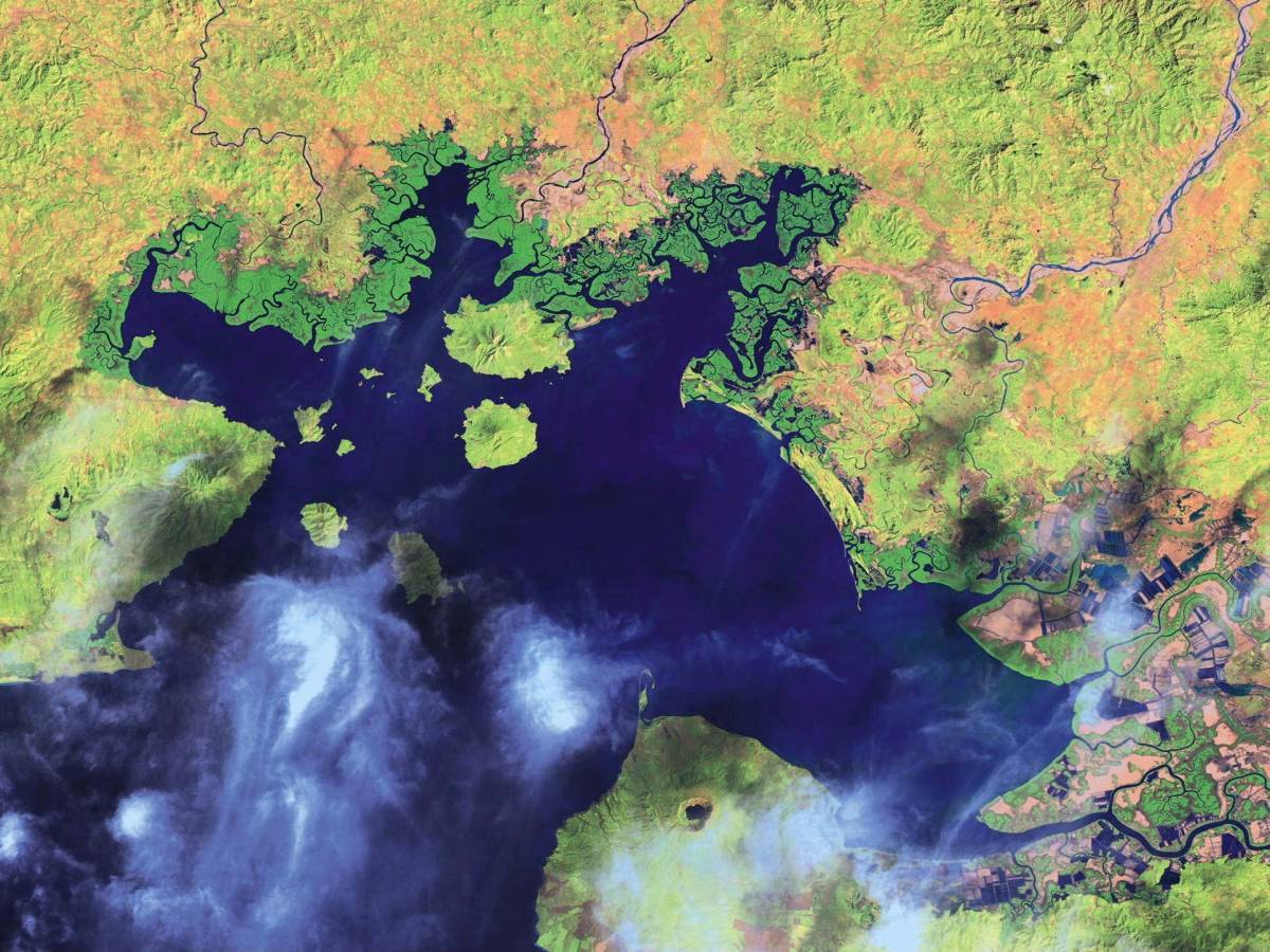
Below the geopolitics, the Gulf sustains one of Central America's most important wetland ecosystems. Six species of mangrove line its shores, organized by nature into zones as precise as any city plan. Red mangroves dominate the permanently flooded areas, their arching roots tangled above the waterline. Black mangroves colonize the riverbanks where sediment accumulates. White mangroves and the shrubby botoncillo prefer higher ground, flooded only by the highest tides. The daily tidal amplitude averages 2.3 meters, and the difference between high and low water creates two distinct worlds: at low tide, crabs and conch emerge on the exposed mudflats; at high tide, fish and shrimp shelter among the mangrove roots, using the tangled architecture as refuge from larger predators. Nearly 80 percent of the Gulf's 1,400 millimeters of annual rainfall falls between May and November, during the rainy season. In the dry months, Pacific currents flow inward, salinity spikes in the estuaries, and seasonal drought grips the landscape.
Empires, Canals, and Gunboat Diplomacy
The Gulf's strategic position has attracted foreign attention for centuries. In 1849, American diplomat E. G. Squier negotiated a treaty to build a trans-Honduras canal connecting the Caribbean Sea to the Pacific via the Gulf of Fonseca. When British commander Frederick Chatfield learned of the plan, he feared it would destabilize the British Mosquito Coast and dispatched his fleet to seize El Tigre Island at the Gulf's entrance. Squier had anticipated the move and already secured the island's temporary cession to the United States. Chatfield was forced to withdraw. In 1917, the conflict shifted to the courtroom when the Bryan-Chamorro Treaty granted the United States rights to establish a naval base in the Gulf, prompting El Salvador to sue Nicaragua before the Central American Court of Justice. The court sided with El Salvador. The United States ignored the decision. By 1989, the United Nations deployed the ONUCA observer mission, patrolling the Gulf by speedboat and helicopter to monitor international tensions that had lingered since the colonial era.
Volcanic Islands in a Warm Sea
A number of volcanoes rise within and around the Gulf, their cones breaking the waterline as islands or looming over the coastal lowlands. The climate is tropical, with average temperatures hovering between 25 and 26 degrees Celsius, warmest in March and April, coolest in November and December. Humidity ranges from 65 to 86 percent depending on location. The Gulf's literary fame comes from an unlikely source: C. S. Forester set part of his Horatio Hornblower novel The Happy Return -- published in the United States as Beat to Quarters -- in these waters, sending his fictional Royal Navy captain through the same channels where real warships once jockeyed for position. From the air, the Gulf is unmistakable -- a broad Pacific embayment fringed by volcanoes and divided by invisible national boundaries that have required five centuries of negotiation and still are not entirely settled.
From the Air
Coordinates: 13.25N, 87.75W. The Gulf of Fonseca is a large, roughly triangular Pacific inlet visible from high altitude, bordered by El Salvador to the northwest, Honduras to the north and east, and Nicaragua to the southeast. Multiple volcanic islands are visible within the Gulf, including El Tigre (Honduras) and Meanguera (El Salvador). The Conchagua volcano (1,243 m) dominates the Salvadoran shoreline. Nearby airports include Toncontin International (MHTG) in Tegucigalpa, approximately 130 km northeast, and El Salvador International (MSLP) at Comalapa, approximately 170 km northwest. The Gulf's mangrove-lined shores and island-dotted waters are distinctive from any altitude above 10,000 feet.