Gyeongju Historic Areas
Gyeongju does not have a museum district. Gyeongju is a museum district -- an entire city built on a thousand years of Silla kingdom civilization, where burial mounds rise from city parks like green domes, stone pagodas stand in schoolyard corners, and the ruins of the largest temple ever built in Korea lie beneath a modern neighborhood. UNESCO recognized this in 2000 by designating the Gyeongju Historic Areas a World Heritage Site, organizing the city's scattered treasures into five zones that collectively tell the story of a kingdom that lasted nearly a millennium, from 57 BC to 935 AD.
The Open-Air Museum of Mount Namsan
The Mount Namsan Belt anchors the southern end of the historic areas around a mountain that Koreans consider sacred. Namsan is sometimes described as a large open-air museum, but that metaphor undersells it -- museums have walls and curators. Namsan has hiking trails that wind past the ruins of 122 temples, 53 stone statues, 64 stone pagodas, and 16 stone lanterns, all scattered across its slopes as if the mountain itself decided to collect Buddhist art. The Namsan Mountain Fortress, built in 591 AD, traces the ridgeline. At its foot, the Poseokjeong Pavilion site preserves an abalone-shaped watercourse where Silla royalty once floated wine cups during poetry competitions -- a courtly tradition that ended abruptly when the last Silla king was assassinated here in 927 AD.
Palaces and Starlight
The Wolseong Belt centers on the ruins of Wolseong Palace, the Silla royal residence, but its most famous feature is something much smaller: Cheomseongdae, the bottle-shaped astronomical observatory built during Queen Seondeok's reign in the seventh century. It is the oldest surviving observatory in East Asia. Nearby, the Gyerim woodland marks the legendary birthplace of the Gyeongju Kim clan, one of Korea's oldest family lineages. The artificial pond Anapji, now known as Donggung Palace and Wolji Pond, was the pleasure garden of Silla crown princes, its waters reflecting pavilion roofs that have been reconstructed on their original stone foundations. At night, the pond is illuminated, and the reflections double everything -- the buildings, the trees, the sky.
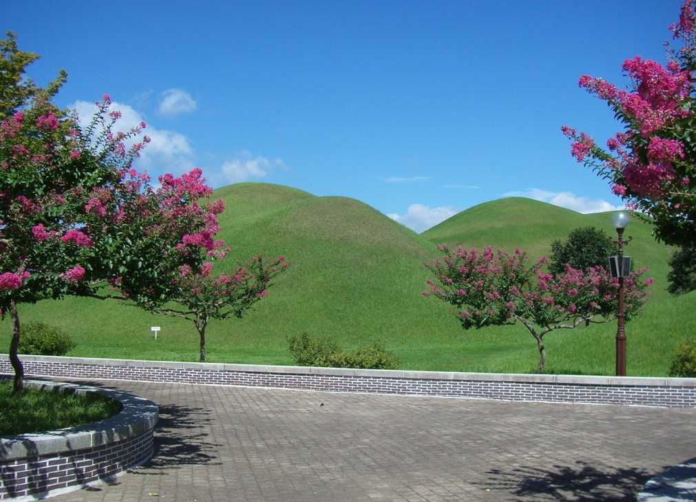
Tombs Like Green Hills
The Tumuli Park Belt is the most visually distinctive zone -- clusters of royal burial mounds that rise from flat ground like enormous grass-covered domes, some shaped like half-moons or gourds. From the air, they look geological, as if the earth itself bulged upward. Inside, excavations have revealed wooden coffins covered with gravel and grave goods of astonishing richness: gold crowns, glass vessels, and fine ceramics that document the Silla aristocracy's taste for luxury even in death. The most famous is the Heavenly Horse Tomb, named for a mural painting on a birch-bark saddle flap depicting a winged horse. The painting is one of the very few examples of Silla pictorial art that survive, and its discovery in 1973 transformed understanding of the kingdom's artistic traditions.
The Largest Temple That No Longer Stands
The Hwangnyongsa Belt preserves the footprint of ambition. Hwangnyongsa, according to its excavated foundation stones, was the largest temple ever built in Korea, covering 72,500 square meters. Its nine-story wooden pagoda was one of the tallest structures in East Asia when it was completed in 645 AD. The Mongol invasions of the thirteenth century destroyed it, and what remains today is the foundation layout -- a ghost map of a vanished colossus. The nearby Bunhwangsa temple, built in 634 AD, still stands and gives some sense of the craftsmanship that characterized this era of Silla construction. Its stone pagoda, built to imitate brick, is one of the most unusual structures in Korean Buddhist architecture.
A Kingdom Written in Stone
The fifth zone, the Sanseong Belt, extends the story to the fortresses along the east coast, including Myeonghwalseong, which protected the kingdom's seaward approaches. Together, the five belts cover not just the physical remains of the Silla kingdom but its full scope: sacred mountains and pleasure gardens, astronomical science and martial defense, royal tombs and monumental temples. Gyeongju was the Silla capital for the kingdom's entire thousand-year history, which means the layers of construction run deep. Walk any direction from the city center and you encounter something that a seventh-century stonemason shaped, or a ninth-century king commissioned, or an excavation team unearthed last decade. The city is still being discovered, one dig at a time.
From the Air
Coordinates: 35.79°N, 129.23°E covering a wide area across the city of Gyeongju and surrounding mountains. The tumuli (burial mounds) are the most distinctive aerial feature -- grass-covered domes clustered in the central basin. Mount Namsan rises to the south with Buddhist ruins on its slopes. Nearest airports: RKTN (Daegu, ~80 km northwest), RKPU (Ulsan, ~40 km south). The five zones are spread across the entire Gyeongju basin, requiring 3,000-8,000 ft altitude to appreciate the spatial relationships between palace ruins, tombs, and mountain temples.