Hadrian's Wall
You can walk the entire length of Hadrian's Wall in about a week, and by the end your boots will have crossed almost every type of English terrain. The trail runs 73 miles from Wallsend on the Tyne estuary to Bowness-on-Solway on the west coast, passing through the centre of Newcastle, climbing onto the dramatic Whin Sill crags of Northumberland, and descending into the gentle farmland of Cumbria. The Wall itself is a UNESCO World Heritage Site, but the experience of walking it is less about a single monument than about an ever-changing landscape threaded with two thousand years of visible history.
East to West: Choosing Your Direction
Most walkers go east to west, starting at Wallsend's Segedunum fort and finishing at the quiet village of Bowness-on-Solway. The logic is partly practical -- the prevailing wind is at your back -- and partly dramatic, since the scenery builds from urban riverbanks to the wild central section before easing into the pastoral west. The best-preserved stretches of Wall and the most visited forts cluster in the middle twenty miles between Hexham and Haltwhistle, where the Whin Sill pushes the Wall onto high ground with views that stretch to Scotland. Newcastle obliterates most of the route through the city, but it compensates with good transport connections, accommodation, and the excellent Great North Museum, which holds finds from across the Wall.
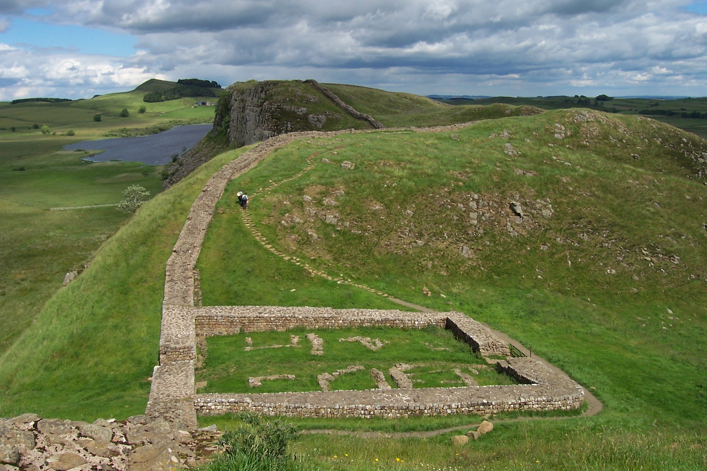
The Central Crags
Between Chollerford and Greenhead, the Wall rides the Whin Sill like a stone serpent. This is the stretch that appears in every photograph, and it earns its reputation. Housesteads, the best-preserved fort, sits dramatically on the crag's edge with its famous communal latrines and the mysterious Murder House in the civilian settlement below. Sycamore Gap -- a dramatic dip between two crags where a lone sycamore once stood -- was one of northern England's most photographed spots before the tree was illegally felled in September 2023; the stump is still there and showing early signs of regrowth. The walking here is strenuous, with constant climbs and descents along the undulating ridge, but the sense of isolation is extraordinary. On a quiet day, you can walk for miles without seeing another person, accompanied only by sheep and the ghosts of the auxiliary soldiers who once patrolled this line.
Forts Worth the Detour
Vindolanda lies just south of the Wall near Bardon Mill and deserves a full day. This pre-Hadrianic fort is still under active excavation, and its museum holds the famous Vindolanda tablets -- personal letters, supply lists, and a birthday party invitation written on thin wooden sheets around AD 100. At Chesters, a cavalry fort in a beautiful riverside setting near Hexham, the bathhouse is one of the most complete in Britain, its underfloor heating system still clearly visible. Birdoswald, further west in Cumbria, sits on a bluff above the River Irthing with extensive remains including a drill hall and granaries. The Roman Army Museum at Carvoran and the museum at Corbridge Roman Town both provide excellent context for what you see along the path.
Practical Matters
The Hadrian's Wall Path is a National Trail with good waymarking throughout. Accommodation ranges from campsites and bunkhouses to comfortable B&Bs and country hotels, though options thin out in the central section and advance booking is essential in summer. The AD122 bus service runs along the Wall corridor between Hexham and Haltwhistle from spring through autumn, making it easy to walk sections without a car or to arrange baggage transfers. Several companies offer self-guided walking packages with pre-booked accommodation and luggage moved between stops. The walking is moderate rather than extreme -- daily distances of ten to fifteen miles with some steep sections on the crags -- but proper waterproof gear is essential in Northumberland, where the weather changes fast.
Beyond the Path
The Wall is not only a walking experience. Hexham, with its medieval abbey and thriving market, makes an excellent base for exploring the central section. Corbridge, a few miles east, is an attractive small town with the remains of the garrison supply base at Corstopitum. Carlisle, at the western end, is a substantial city with its own castle and cathedral, plus good rail connections south to the Lake District. For those who cannot walk the full trail, the central section from Steel Rigg to Housesteads offers the most dramatic scenery in a manageable half-day walk. However you experience it, the Wall rewards patience. Its scale only becomes apparent when you stand on the crags and trace its line running east and west until it disappears into the haze, a stone thread stitching together coastlines seventy-three miles apart.
From the Air
Hadrian's Wall runs 73 miles from Wallsend (55.01N, 1.53W) on the Tyne to Bowness-on-Solway (54.95N, 3.22W). The most dramatic aerial views are in the central section where the Wall follows the Whin Sill crags between approximately 54.99N 2.20W and 55.02N 2.50W. The Wall line, forts, and milecastles are clearly visible from 2,000-5,000 ft AGL. Key landmarks: Housesteads fort, Sycamore Gap, Steel Rigg. Nearest ICAO: EGNT (Newcastle) to the east, EGNC (Carlisle) to the west.